Historic Waterway to the West: The Chesapeake and Ohio Canal National Historical Park

Cushwa’s Warehouse stands along the canal in Williamsport, Maryland, its brick façade and calm reflections echoing the rich history of the C&O Canal National Historical Park.
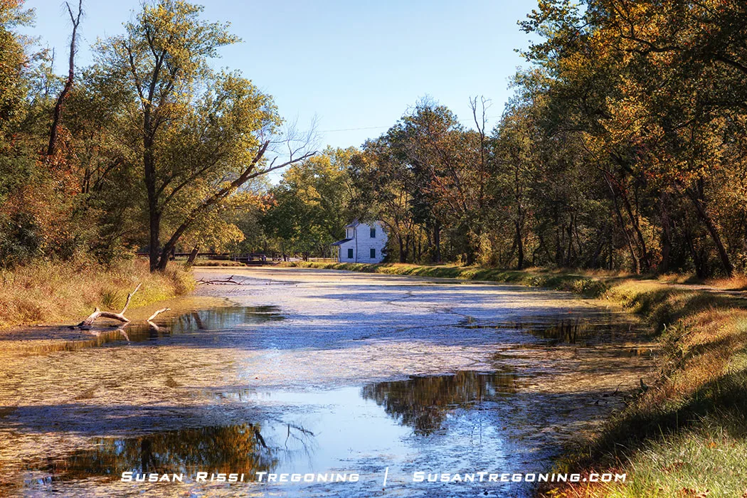
The year 2021 marked the 50th anniversary of the Chesapeake and Ohio Canal National Historical Park joining the National Park System. The park preserves the historic 19th‑century transportation canal that once stretched from Washington, D.C., to Cumberland, Maryland. Since 2019, it has consistently ranked as the 11th most‑visited national park in the United States, with Great Falls drawing the highest number of visitors along the canal’s 184.5‑mile towpath. Many people stop at the Great Falls Tavern but rarely explore beyond the canal’s first 14.5 miles.
Because no road runs directly beside the C&O Canal, the towpath is especially popular with hikers and cyclists. Wanting to avoid the city crowds and experience more of the canal’s quieter beauty, I set out to explore some of its lesser‑visited highlights. Knowing I couldn’t see everything in one trip, I chose to drive between select points along the canal, taking a series of short hikes at each stop.
There is so much history along the C&O Canal that I could almost feel the ghosts of the past walking along the towpath with me. I visited the canal in 2020 when all the visitor centers were closed, and I left with so many unanswered questions that I wished I had been better versed in the canal's history before I went. The C&O Canal stuck with me, giving me a need to understand the people, the mechanics of how locks worked, and many other things that this blog post took on a life of its own. Yes, I've been told in the past that I write too much. LOL
I hope to complete this park one day. While I love historical sites, I found the C&O Canal even more interesting than I expected.
The history of the C&O Canal comes first, but if you aren't into that, scroll down to the section on the C&O Canal by towpath mile, which is clearly marked below.
A four mile section of the C&O Canal in Oldtown, Maryland has been rewatered. It is also known as Battie Mixon Pond in honor of the Natural Resources Officer who led the community's rewatering effort in the 1940s and 50s.
The History of the C&O Canal
As America grew and expanded, infrastructure was needed to send resources and supplies Westward. Dubbed "The Great National Project," the Chesapeake and Ohio Canal took 22 years to construct, employing thousands of immigrants along the way.
As far back as 1785, George Washington proposed a canal. He advocated using waterways to connect the Eastern Seaboard to the Great Lakes and Ohio River. Washington formed the Patowmack Company to improve navigation on the Potomac River by bypassing its waterfalls and rapids. The C&O Canal incorporated these canals into its canal system.
The transportation race was on when both the Chesapeake and Ohio Canal Company (C&O) and the Baltimore and Ohio Railroad (B&O) began construction on the same day, July 4, 1828. While initially not considered a race, B&O soon competed with the C&O for property rights over the narrow right of way along the Potomac River. The construction routes of the two companies finally collided at Point of Rocks. A bitter and expensive four-year battle ensued, halting construction for both until 1832, when the courts ruled in the canal's favor.
Even though C&O won the right of way, B&O won the race with their first train arriving in Cumberland on November 1, 1842. It was eight more years before the C&O Canal would make it to Cumberland on October 10, 1850. After spending 14 million dollars on its construction and failing to reach its intended goal of the Ohio River, C&O decided to stop the canal at Cumberland since they could not compete with rail’s speed or capacity, making it nearly obsolete.

The Potomac River from the Fifteen Mile Creek boat dock.
Still, the 184.5-mile-long C&O Canal was an important commercial link between the East and the West for almost a century. The business grew slowly; the canal was a major target of the Confederacy during the Civil War, and seasonal flooding was always an issue. It was only profitable for four years. During its peak, in the 1870s, the canal boats moved almost a million tons of freight a year.
A devastating flood destroyed the canal in 1889, forcing the C&O Canal Company into bankruptcy. No boats moved for 18 months. Finally, to avoid letting the right of way fall into the hands of their rival company, Western Maryland Railroad, B&O, as the primary creditor to the C&O Canal Company, took over the receivership under the name Consolidation Coal Company. This agreement made B&O responsible for maintenance and operations until 1938.
As the canal's business began to dwindle, B&O started selling off parts of the basin. Western Maryland Railway was able to purchase the canal's terminus, fill it in, and build a railroad station over it.
By the early 1920s, the slow-moving canal boats could no longer compete with the railroad. The canal closed in 1924 after a flood destroyed many of its banks and locks. In 1938, when the receivership ended, B&O sold the canal to the United States Government for $2 million, which they paid to the primary holders of the 1844 and 1878 bond mortgages.
Canallers - Life of the Canal Builders
While a few slaves were used early on, the canal was primarily constructed by English, Irish, and German immigrants and a few native-born Americans. They worked 12 to 15 hours a day, no matter the weather. Skilled tradespeople, carpenters, and stonemasons built the 74 locks, 64 lock houses, 11 aqueducts, 7 dams, over 150 culverts, and a 3,100-foot-long tunnel.
The Paw Paw Tunnel was the site of some of the worst race‑related labor riots along the C&O Canal.
The 184.5-mile canal prism, originally 6 feet deep and 60 to 80 feet wide, was hand-dug by the lowest-paid workers. It was back-breaking labor since they only had shovels, picks, and wheelbarrows at the time. Their days were spent in ditches, up to their waists in mud and water. It was dangerous and challenging work; injuries were common, and maiming and even death occurred frequently.
Living conditions along the canal were very primitive. Many married laborers traveled with their families, living in makeshift shanty towns near their worksites. Wives were not employees of the C&O Company but managed the camp's domestic life. Single laborers often slept in bunkhouses with 15 to 20 other men. These poor living conditions made serious illnesses a threat, and hunger was common. Epidemics commonly swept down the canal line, leaving a trail of bodies in their wake.
Miserable living and work conditions led to fighting among the Canallers. C&O was struggling financially and sometimes withheld wages. Work crews were often pitted against each other for jobs, leading to sporadic unrest, violence, ethnic conflicts, riots, and strikes.
Lock 75 is the farthest lock west before the canal enters the “nine‑mile level” leading to the Cumberland terminus.
The Lock Tender
As soon as the canal was constructed, the C&O company started looking for lockkeepers. They wanted sober, reliable family men for these jobs. Every lockkeeper received a lockhouse rent-free just a few feet from their lock, one acre of land for gardening and raising animals, and $150 a year (by 1870, it was $600). If he worked more than one lock, he was paid an additional $50 for each lock he tended (this increased to $150 by 1870). Besides lock tending, keepers were required to do minor repairs on the locks, maintain the canal water level, and provide any additional help they needed. For this reason, married men with large families were the perfect candidates for the job.
Lock tending was hard work. A lock keeper was expected to work 24 hours a day, 7 days a week, 365 days a year. There was no time off since a canal boat could come through at any time of the day or night.
The pay wasn’t much. It was about what an unskilled factory worker made in the city. The garden helped put food on the table, and any extra produce was traded for coal and other necessities. Many wives baked pies and bread to trade. Children helped with the locks, and in the garden, they were also expected to fish and hunt for meat. C&O paid a bounty reward for muskrat, which was another way the kids helped bring in extra money. C&O also allowed tenders to rent rooms to travelers if they had the space.
The canal was a 184.5-mile long lineal community with as many as 530 canal boats on the water at any given time. The locks were common stopping points, so they became small communities and gathering places with grocery stores, and feed stores opening up nearby.
C&O made it attractive for merchants to set up shop along the canal and the merchants were the only ones to get wealthy off the canal venture. The annual rent for a feed store was $36 a year. In the 1870s, the mules used for towing the canal boats were consuming 25,000 barrels of corn, 3,840 bushels of oats, and thousands of tons of hay every year!
Operating the Locks
When a canal boat passed through a lock, the boat captain put his life and livelihood into the hands of the lock tender. The wooden lock gates were a delicate balance between safety and efficiency. While the gates had to be lightweight enough that one man could operate them, they also had to be strong enough to hold back 140,000 gallons of water. A lock tender's job was to keep the water flow in and out of the lock adjusted, minimizing risk to both the boat and lock.
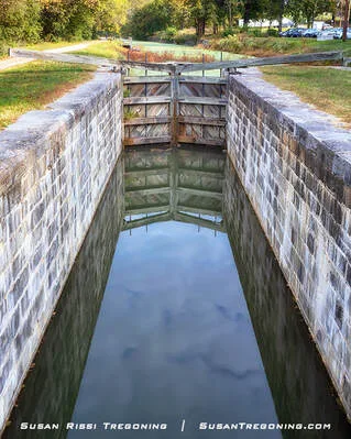
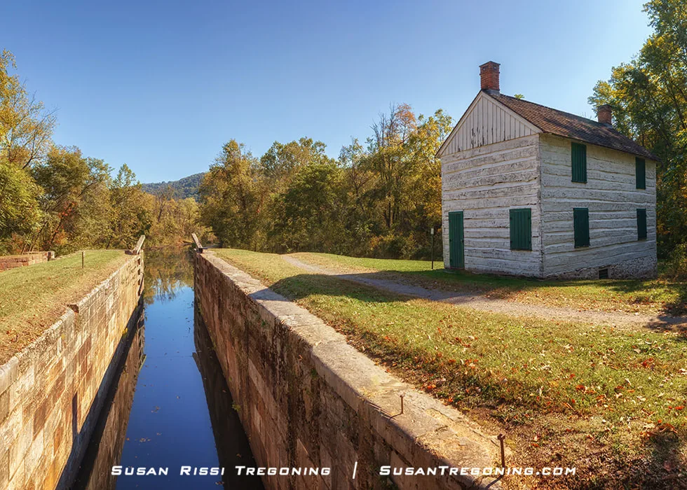
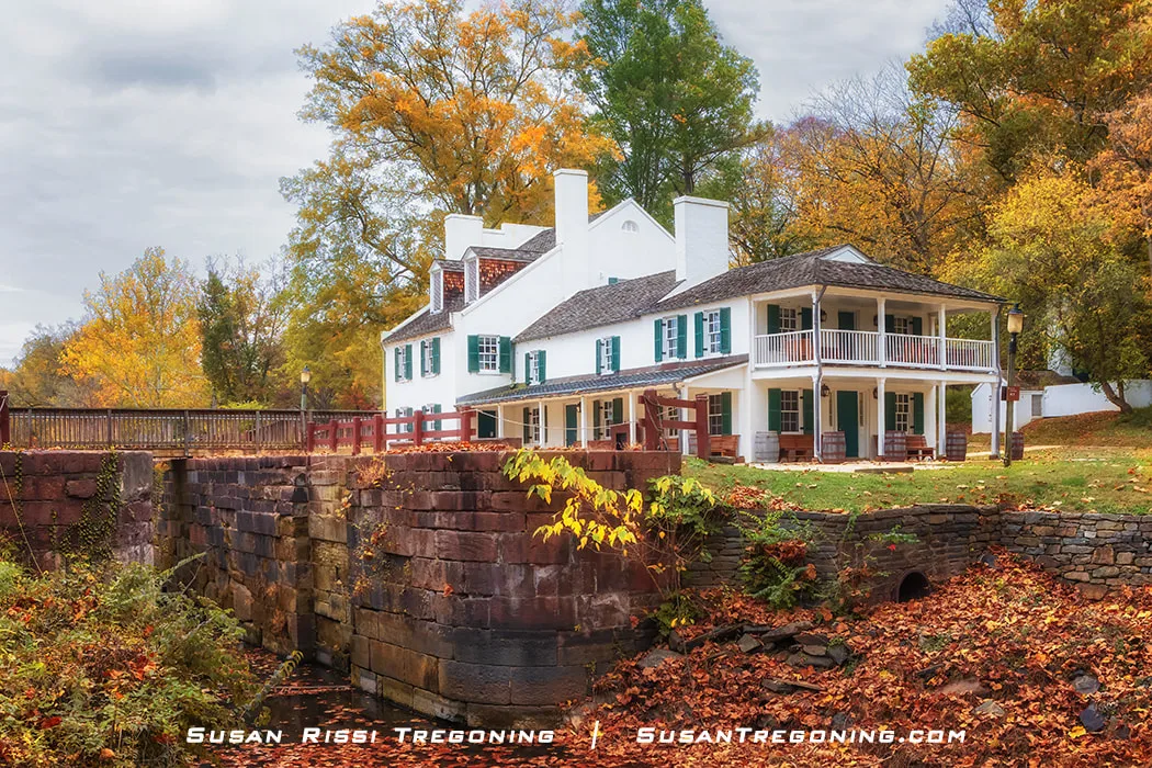
Looking down into the watered lift lock at Lock 44 in Williamsport, Maryland.
A lock is basically an elevator for a boat. It uses water to lift a boat up or down to the next level in the canal. The C&O Canal locks are 100 feet long by 15 feet wide, leaving six inches on either side and one foot on each end of the canal boat when it is inside the lock. There are 74 lift locks to complete a total elevational change of 605 feet along the entire length of the C&O Canal.
Here is an example of the ten—to fifteen-minute "lock-through" process. While one person can do it, it's much easier with two.
The mules are unhitched and led downstream. Using ropes attached to the boat, the lock keeper guides the canal boat into the lock to prevent damage to the boat or the lock walls. Once the boat is inside the lock, it is tied to snubbing posts to keep it secure. The lock tender pushes the large balance beams on either side of the lock to close the gate doors. The boat is now completely enclosed within the lock. Using a lock key, the lock keeper opens the butterfly or wicket valves at the gates' bottom to lower or raise the water level depending on which direction the canal boat is traveling. Once the water level is equalized in the direction the boat is headed, the lock gates are opened back up, and the boat is pulled out. The mules are hitched back up, and the boat continues on its way.
Canawlers - The Canal Boatmen
The canal boat season was about eight months long, from March through December. Once the canal froze, the water was drained, and the boats sat on the bottom until Spring.
On average, a trip down the canal took 5-7 days. Most canal boats could make two round trips per month. It took a crew of three to five to operate a canal boat, and the Captain paid them out of his earnings. Since the pay was already low, canal boats were usually family businesses.
Many women and children were on the boats, and every member had their jobs. The Captain was generally on the bow (front) to grab a line or pole if something went wrong. "Women's work," cooking, cleaning, sewing, and taking care of the children, was done by the tiller near the living quarters at the boat's stern (rear) since women were also in charge of the steering. Women were also responsible for changing the mule teams. Very young children were tethered to the deck so they didn't fall off. By the time the kids reached seven years of age, they were extra hands on deck and responsible for the mules. They brushed, harnessed, fed them, cleaned the stable, and were the mule drivers walking with them along the towpath. At night, the children carried lanterns while riding the mules to help their parents steer in the dark.
It was such a transient lifestyle that the children who lived on the boats could not attend school during the canal season. Some children went to school during the off-season but were always so behind that most never learned much. Many were illiterate, as were their parents.
It was common for the boys to grow up to captain boats and the girls to marry into canal boat families.
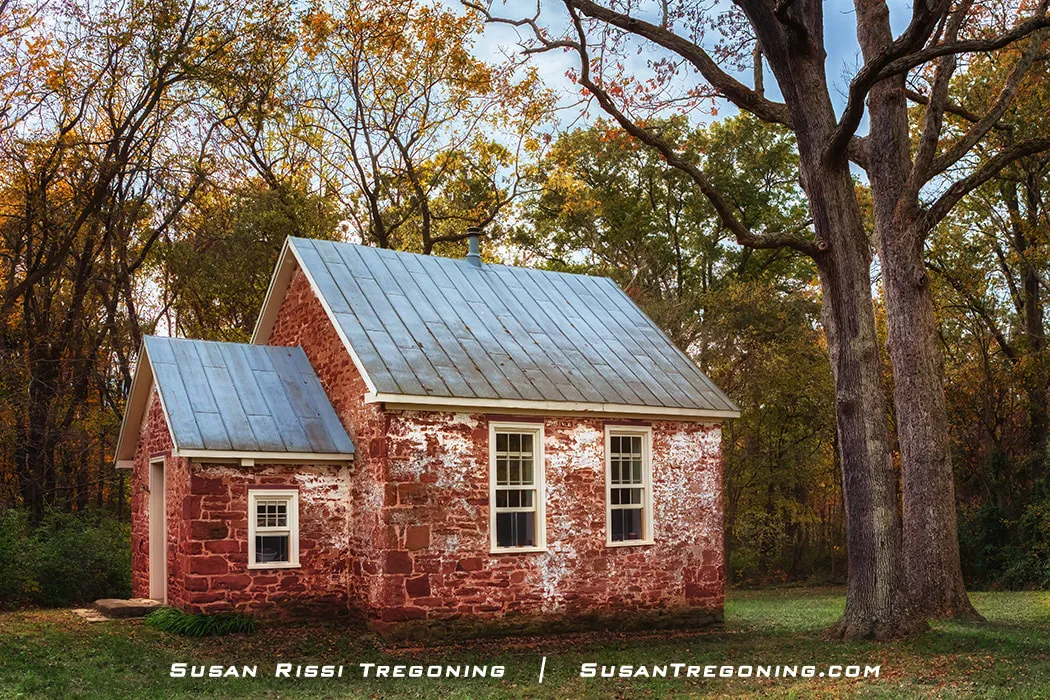
Many Canal boat children went to the Seneca Schoolhouse during the offseason.
Directions on the canal were upstream, downstream, riverside, and bermside. The towpath was usually on the riverside, but there were a few exceptions.
Downstream is traveling from Cumberland to Washington, D.C. When traveling downstream, the boats primarily transported coal, but they also moved fresh produce, lumber, wheat, flour, oats, pork, grain, whisky, cement, and red sandstone.
Upstream is traveling from Washington, D.C., to Cumberland. The boats traveling upstream transported goods and merchandise to the settlements and lock houses, including food such as salt, salted fish, oysters, potatoes, bricks, and manufactured goods.
Canal boat operators were considered the "working poor." A boat captain making two round trips a month might earn about $50 a month, which is equal to around $800 a month today.
C&O made its money through tolls and traffic regulations. They charged a $15.50 toll each way to use the canal. The canal had a speed limit of 4 mph, and if caught speeding, the penalty was $5.
Spring Gap on the north branch of the Potomac River near “the Narrows” on the C&O Canal.
The Mules
Mules were the preferred engines for canal boats. Harnessed slantwise, which is one mule behind the other, they pulled the boat straighter than when harnessed abreast. Because of the extreme weight they were pulling, mules had to be re-shod about every other trip to Cumberland and sometimes more often.
During the canal's peak years of the 1870s, approximately 3000 mules worked on the C&O Canal. Most canal boat captains treated their mules like pets and cared for them like part of the family. They were well-fed, eating corn, hay, and oats.
A boat captain typically owned four mules. Two worked while the other two rested in a Mule Stable on the boat's bow. A workday for a pair of mules, known as a trick, was a six-hour shift covering about 16 miles while pulling a 90 x 14-foot barge carrying something like 120 tons of coal (an average load) along the canal.
The Mule Barn at Four Locks has been reconstructed as a testament to the hard-working mules along the C&O Canal.
During the winter off-season, most captains preferred to send their mules to a Mule Barn, paying a mule tender to care for them. Mules were not always well cared for at the barns and were commonly underfed.
Boat captains preferred mules over horses because they had a horse's size and temperament and a donkey's strength and endurance. They were less prone to illness and injury, had longer life spans and work lives, and were cheaper to purchase. More sure-footed than horses, mules were less likely to trip and injure themselves when pulling such weighty loads.
C&O Canal by Towpath Mile Marker
Once you get out past the D.C. Metro/Great Falls area, many of these locations are fairly rural. When possible, I have added addresses to sites and GPS coordinates for the most rural locations. I did not always have cellular internet. Do not rely on your cell phone for maps; have a GPS with you.
I traveled the C&O Canal in reverse, starting at the terminus in Cumberland, Maryland. I reversed the information for this post since it makes more sense to count up the towpath miles. I could not resist visiting Great Falls Tavern since Great Falls is the #1 MUST-SEE location, but I didn't go any further into the city.
I have added some brief notes for the C&O Canal sites that I missed. Many locations were skipped because of time constraints, and heavy rain showers hindered my last day on the Canal. I skipped it if there wasn't a parking lot on-site or it was raining. I was very disappointed to miss out on towpath miles 16.7 - 22.8. I had planned to hit Great Falls again on my final day and then backtrack over some of the areas I missed, but I had to scrap the last day entirely because of the weather. For that reason, there are some good-sized gaps between locations from towpath mile 14.5 through 88.1.
Overall, I was fortunate; the towpath was very dry while I was hiking it. I have read many accounts of the dirt trail being nothing but mud. Take that into consideration when you plan your visit.
14.4 Great Falls Tavern - C&O Canal Visitors Center
11710 Macarthur Blvd, Potomac, Maryland
This is the only location along the canal that collects National Park admission fees. The canal at the Great Falls Tavern is usually watered, but in 2020, I was disappointed to discover it was not.
Lock 20 is the most well known of the of "Six Locks" at Great Falls. The Great Falls Tavern is also Lockhouse 12.
The very first lock tender at Great Falls, knowing that he was in a special location because of the falls, convinced C&O to build an inn and allow him to run it.
The inn became a destination for people living in Washington, D.C. They could hop a packet boat in Georgetown, 14 miles away, and be there in 6 to 8 hours. It was the perfect weekend getaway! It was so popular that in the early 1900s, the Washington Railway and Electric Company ran a trolley line between Washington, D.C., and Great Falls to make it more convenient.
The Great Falls Tavern is still the most popular canal location along the Chesapeake and Ohio Canal. In season, they do mule-drawn canal boat rides here. Besides the falls, don't miss seeing the Washington Aqueduct.

Great Falls delivers one of the Potomac’s most unforgettable scenes, where roaring whitewater meets steep rocky cliffs and brilliant fall foliage.
16.7 - Lock & Lockhouse 21 - Swains Lock
10700 Swains Lock Road, Potomac, MD
Part of the Canal Quarters program along with Lockhouses 6, 10, 22, 25, 28 and 49.
19.6 - Lock & Lockhouse 22 - Pennyfield
GPS: 39.0548142,-77.2948962
This is the lock where President Grover Cleveland liked to fish.
Canal Quarters info for Lockhouse 22.
22.1 - Lock 23 - Violettes Lock & Dam No. 2 ruins
GPS: 39.0670517, -77.328637
Double lock of Seneca red sandstone.
22.8 - Seneca Creek Aqueduct
13025 Rileys Lock Rd, Poolesville, MD
Both Rileys Lock 24 & Rileys Lockhouse (open on Saturdays in season) and the
Seneca Stone Cutting Mill Ruins where they milled the stone for the Smithsonian Castle are located at the Seneca Creek Aqueduct.
30.9 - Edwards Ferry - Lock & Lockhouse 25
End of Edwards Ferry Road, Poolesville, Maryland
GPS: 39.1037595,-77.4726735
Behind Lockhouse 25, scattered stonework and warm fall foliage reveal the quieter, workaday side of life along the C&O Canal.
Lockhouse 25, is located in what was once the sleepy little town of Edwards Ferry, Maryland. Other than the lock and lockhouse, not much remains but the ruins of Jarboe's store. There is a nice boat ramp where the ferry boat used to land.
When the canal opened in 1833, the community of Edwards Ferry sprung up overnight. Edwards Ferry was the canal entry point for agricultural goods across the Potomac River from Virginia that were headed to Georgetown.
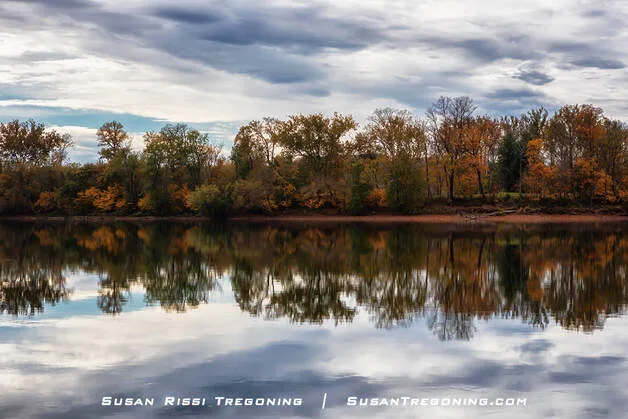
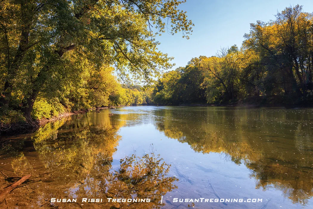
Reflections on the calm Potomac River from the Edwards Ferry boat ramp.
During the Civil War, the north bank of the Potomac became a militarized border. Edward's Ferry was a strategic hot spot with both the Union and the Confederate troops using the ferry crossing. With the canal's proximity to the Potomac, it was often the Confederate force's target in an attempt to interrupt commerce. It was so bad that families in the area feared leaving their homes, and the Union often occupied their fields while protecting the canal. Life in Edwards Ferry eventually calmed down as the war moved south into Virginia.
Canal Quarters info for Lockhouse 25.
39.4 - Lock 26 - Woods Lock
It has been filled in.
41.5 - Lock 27 & Stone Lockhouse - Spinks Ferry
No close parking, you must hike to it from the Monocacy Aqueduct.
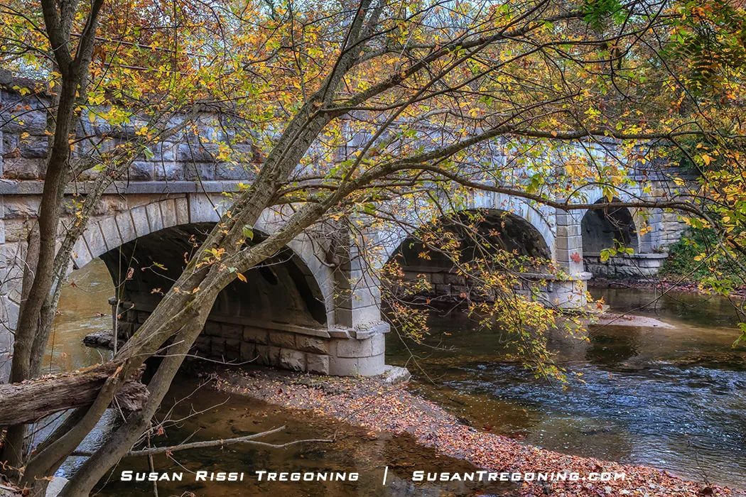
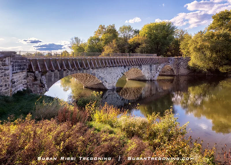
42.2 - Monocacy Aqueduct
21115 Mouth of Monocacy Rd, Dickerson, Maryland
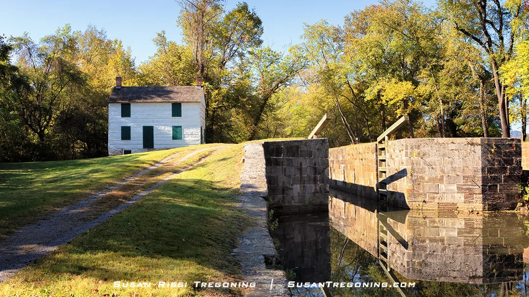
The Monocacy Aqueduct is the largest aqueduct along the C&O Canal.
The Monocacy Aqueduct, also known as C&O Canal Aqueduct #2, is the largest of the 11 aqueducts constructed on the Chesapeake & Ohio Canal. It comprises seven arches, each spanning 54 feet near Dickerson, Maryland. The aqueduct’s length is 438 feet from abutment to abutment. It crosses the Monocacy River just before it empties into the Potomac River.
Described as one of the finest aqueducts in the United States, its scale is considered a significant engineering accomplishment when it was built in 1829-1833. Constructed mainly out of large quartzite stone blocks quarried from the base of Maryland's Sugarloaf Mountain, the stones were carefully placed together and painstakingly hand-shaped by masons once on site. The aqueduct cost $127,900 to construct.
In 1972, engineers designed a steel banding system to stabilize the structure after the Hurricane Agnes flood and installed steel rods to reinforce it. In 2004-2005, after restoring the Monocacy Aqueduct to its original state, they were able to remove the steel banding.
48.2 - Point of Rocks
GPS: 39.2730567, -77.5414085
When I visited, this section of the towpath was closed. The C&O Canal towpath can be accessed from the parking lot near the Point of Rocks boat ramp.
Point of Rocks Train Station
4000 Clay Street, Point of Rocks, Maryland
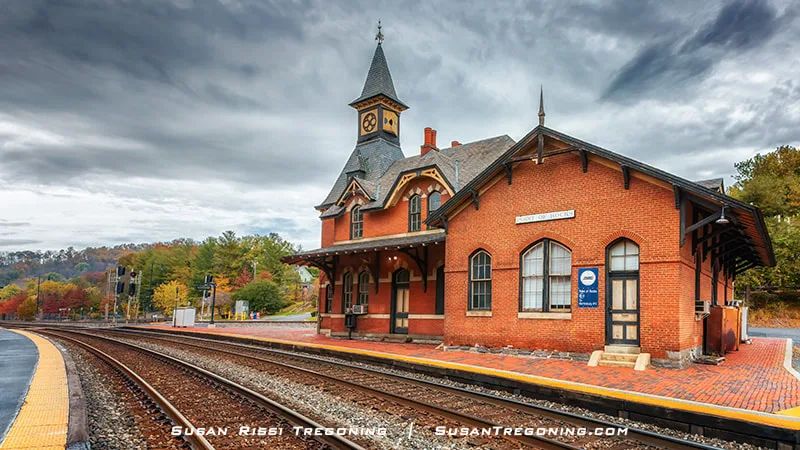
Point of Rocks Station, often called the most photographed train station in the United States, framed by autumn color and timeless Victorian charm.
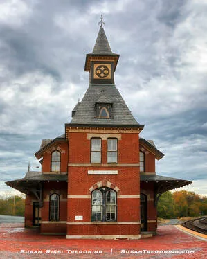
Point of Rocks rises with its iconic tower, arched brickwork, and slate roof, framed by the warm colors of fall.
The historic Point of Rocks Train Station, built in 1876, was designed to showcase the B&O Railroad’s new line connecting the West to Washington, DC. Architect E. Francis Baldwin—known for shaping many of the railroad’s most iconic stations—considered this Gothic Revival masterpiece his signature work. Constructed of red brick and local sandstone, the station sits on a narrow triangular plot where two rail lines converge. Although no longer open to the public, the building remains in use today as storage and office space for CSX.
49.0 - Lock & Lockhouse 28
Part of Canal Quarters program
To get here, you must hike in from either Point of Rocks or Lander.
50.8 - Lock & Lockhouse 29 - Lander
GPS: 39.3065217,-77.5581753
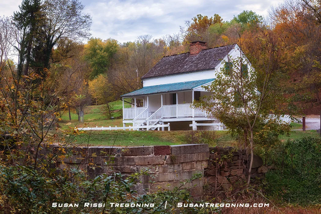
Tucked into the woods along the C&O Canal, Lander Lockhouse 29 stands with its white siding, green metal roof, and brick chimney. It's one of the canal’s most peaceful surviving lockkeeper homes.
This simple brick home with a deep front porch is Lander Lockhouse #29, located near Jefferson, Maryland. The lock is constructed of granite from the Patapsco River and white flint stone from across the river in Virginia.
The last lockkeeper to live in the home was Lewis Cross. The Cross family continued to rent the house for $20 a year even after the canal stopped operations in 1924. When Mr. Cross died in 1962, the lockhouse became the property of the National Park.
In Civil War history, this was where John Mosby’s Confederate raiders crossed the river on the 4th of July in 1864, headed to the Calico Raid at Point of Rocks. When the raiders encountered a holiday excursion boat of treasury clerks approaching Lock 29 on the canal, they scared off the lockkeeper, leaving the canal boat stranded. The treasury clerks forced to abandon ship made a run for it. At this point, Mosby’s raiders set their vessel, “The Flying Cloud,” on fire and continued.
Today, the little town of Lander has a population of around 50, but when the canal was still operational, the town was busy enough to support a post office and two general stores. The Lander house is occasionally open for public tours.
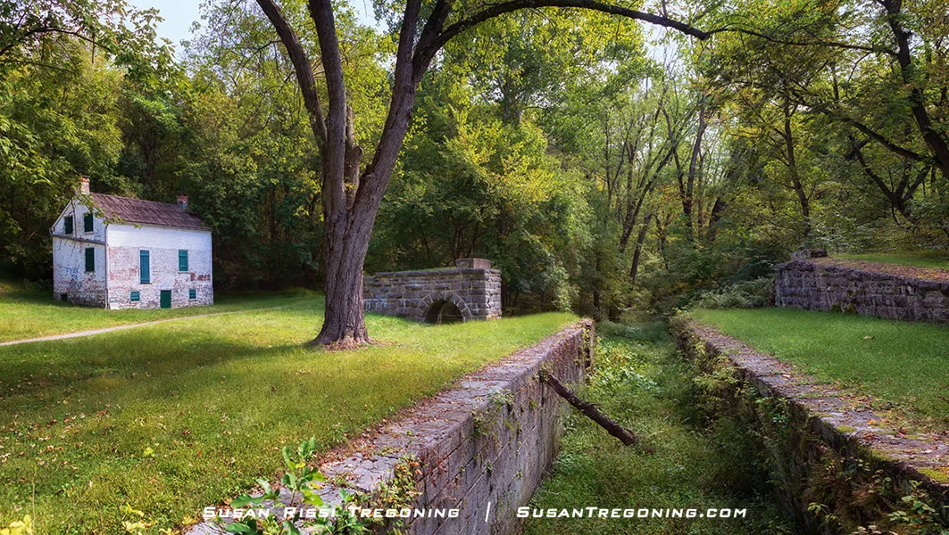
51.5 - Catoctin Aqueduct
Hike in from Landers Lockhouse 29.
54.0 - Brunswick C&O Canal Visitors Center
40 West Potomac St, Brunswick, Maryland
55.0 - Lock 30
GPS: 39.311322,-77.631053
Brunswick boat ramp parking lot
58 - Lock & Lockhouse 31
GPS: 39.3294461, -77.6810422
There is parking along the road at the end of Keep Tryst Road.
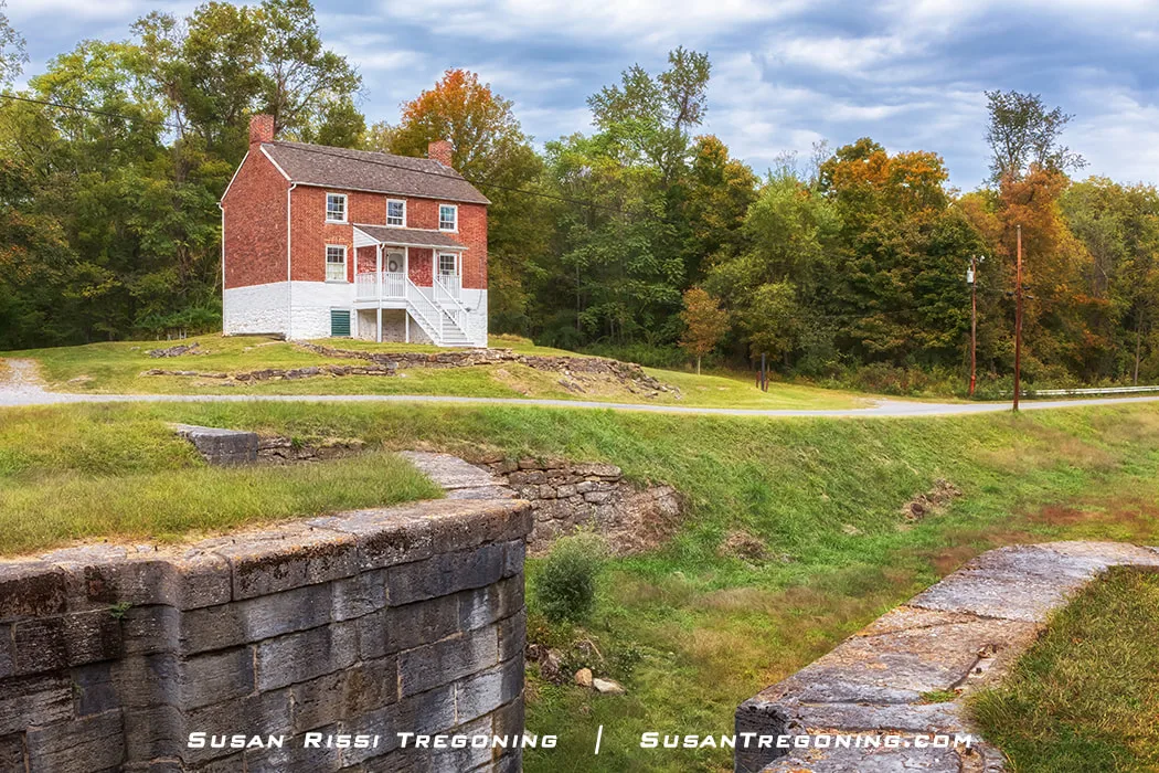
At Lock 31, the canal’s past feels close—its red‑brick lockhouse overlooking the old stone lock and the quiet, grassy channel below. Surrounded by autumn hills, this remote site hints at the long days and steady work that once defined life along the C&O.
Lock & Lockhouse 31 is just over the Maryland state line from Harpers Ferry, West Virginia. This red-painted brick lockhouse is unique since most of the lockhouses along the C&O Canal were painted white, making them easier to see in the dark.
Constructed around 1870, it cost $1720 to build.
60.2 - Lock 32
60.7 - Lock & Lockhouse 33
Use the Appalachian Trail Bridge from Harpers Ferry to access the towpath to hike to both of these.
60.8 - Harpers Ferry - Harpers Ferry National Historical Park
171 Shoreline Drive, Harpers Ferry, West Virginia
Harpers Ferry National Historical Park is amazing! I have visited several times, just not on this trip. Don't miss it!
61.5 - Lock 34
62.3 - Lock 35 & Remains of Dam 3
62.4 - Guard Lock for Dam 3
62.5 - Lock 36
64.9 - Dargan Bend
GPS: 39.3639494,-77.7487636
Parking at the boat ramp.
65.2 - Shinhan Lime Kiln
65.4 - Dargan Bend Cave
66.0 - House Falls & Cow Ring Sluice
66.9 - Lock 37 - Mountain Lock
67.4 - Mountain Lock Recreation Area Parking
18207 Mt Lock Canal Rd, Sharpsburg, MD
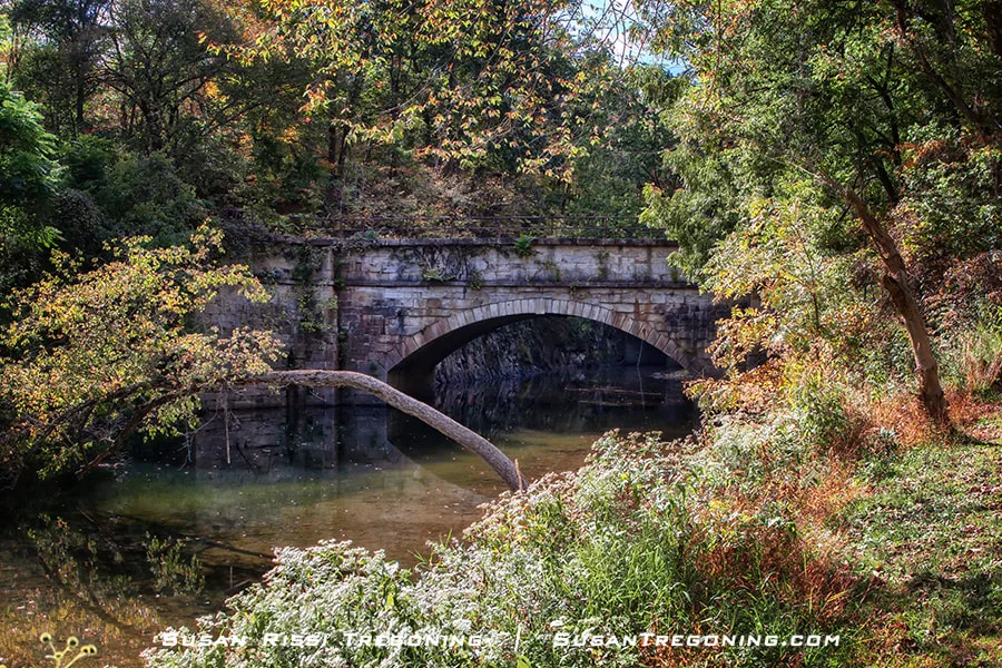
69.4 - Antietam Creek Aqueduct
South of Sharpsburg on Canal Road
GPS: 39.4256678, -77.7558925
Parking is available along the road beside the Antietam Creek Campground, which is just a short walk downstream from the campground.
Built of local limestone in the 1830s, the Antietam Aqueduct stands as one of the C&O Canal’s most graceful engineering works—its triple arches spanning Antietam Creek amid the soft hues of fall.
Near Sharpsburg, Maryland, the Antietam Aqueduct crosses Antietam Creek, one of the major tributaries feeding the Potomac River. First constructed in 1834, the three-span arched Antietam Aqueduct is 140 feet long and was the fourth of 11 aqueducts built along the C&O Canal.
The Battle of Antietam, one of the most critical events in the Civil War, took place nearby on September 22, 1862. Some say that Antietam Creek ran red that day from the blood of 22,720 Union and Confederate troops killed, wounded, or unaccounted for on this one day of fighting. The aqueduct was heavily damaged during the battle and later rebuilt.
This aqueduct completely collapsed in 1973 and was restored in 2011.
72.7 - Lock 38
GPS: 39.4364671, -77.799633
Parking on site
72.8 - Ferry Hill Plantation - C&O Canal Visitors Center
16500 Shepherdtown Pike, Sharpsburg, Maryland
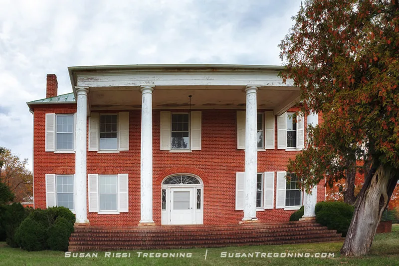
Overlooking the Potomac, Ferry Hill Plantation showcases early 1800s craftsmanship with its red‑brick walls, tall white columns, and commanding hilltop setting—one of the region’s most distinctive historic homes.
John Blackford built this brick home at the heart of his plantation between 1812 and 1820. With almost 700 acres of land, there was also a tavern and ferry. Blackford advocated for building the C & O Canal, which crossed the lower part of his property.
Located high above the Potomac River on the bluffs, this was such an important and strategic location during the Civil War that the homes and grounds were occupied by both the Union and the Confederate troops at different times during the war.
74.0 - Lock 39
Hike from Ferry Hill
79.4 - Lock 40
80.9 - Taylors Landing
GPS: 39.4989538, -77.7675689
There's parking here.
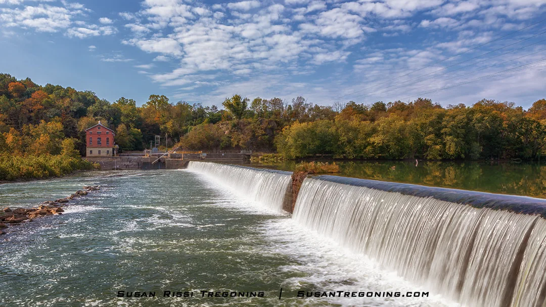
84.4 - Dam 4 & Stop Gate
GPS: 39.4959473, -77.8261247
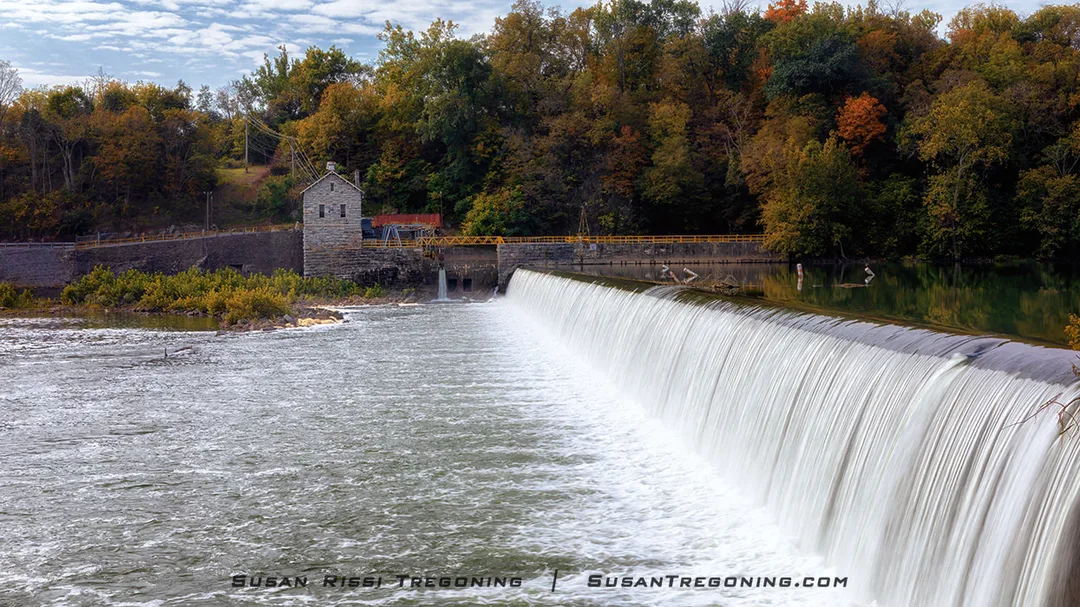
At Dam 4, the Potomac pours over the long spillway in a smooth, white cascade. Built to supply water to the C&O Canal, the dam still anchors this historic stretch of river, with the stone control house tucked into the autumn trees beyond.
Dam 4 supplies water for 22 miles of the C&O Canal, from mile 84.6 to just above Harpers Ferry at mile 62.3. The water roaring over the spillway is powerful enough to send vibrations through the ground. Built to create the Big Slackwater, this hydroelectric gravity dam was completed in 1913 and later modified in 1994. It uses a drive‑belt system to transfer the Potomac River’s energy to turbines, providing electricity to Washington County residents. The building on the West Virginia side of the river is the Potomac Edison Power Plant, which has harnessed the river’s power for more than a century and today supplies electricity to one‑third of Shepherdstown, West Virginia.
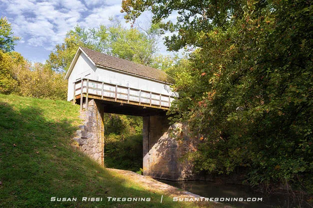
The Stop Gate Wench House spans the canal at Dam 4, a small white structure once used to raise and lower the stop gate controlling water flow.
The Stop Gate Wench House sits over the canal near Dam 4. While this building looks slightly like a covered bridge, it’s not. This building held the stop gate. The gate would be lowered to prevent floodwaters from entering the canal and damaging the towpath. It was used to maintain a consistent water level so it did not exceed a traveling speed of two miles per hour down the canal.
Canal boats entered and exited the canal through the Stop Gate just a short distance above Dam 4 after traveling on the Big Slackwater section of the Potomac River.
85.6 - Big Slackwater
GPS: 39.4997202, -77.8440399
The Big Slackwater Area starts here and extends to McMahons Mill.
There's parking here.
88.1 - McMahons Mill & Big Slackwater
7900 Avis Mill Rd, Williamsport, Maryland
McMahons Mill is one of the access points for the Big Slackwater area of the Potomac River. This area's peacefulness and serenity are second to none along the C&O Canal.

McMahon’s Mill stands along the C&O Canal, its red wooden walls and tall water wheel recalling the mill’s 19th‑century working days.
McMahon's Mill, built around 1778, has been operated by many different owners. Known as Charles Mill, Cedar Grove Mill, Shaffer's Old Flouring Mills, and Avis Mill, its current name is the name of its final owner.
In the early twentieth century, the mill used a steel wheel to generate electricity. It was always a successful grist mill. It was finally closed in 1922 due to flood damage.
In the 1960s, the William McMahon family purchased a nearby home, and the mill property was part of the acreage. The National Park Service acquired the mill from him in 1976, restoring it for the C&O Canal National Historical Park. It provides a peek at one type of industry that once operated along the canal.
Big Slackwater forms a wide, lake‑like stretch of the Potomac where canal boats once left the canal prism and traveled directly on the river.
Big Slackwater, created with Dam 4, makes a calm lake-like area out of the Potomac. The canal boats exited the C&O Canal and traveled directly on the Potomac River to bypass the solid rock cliff walls through this area. It was a more economical solution than blasting through solid rock to continue the canal. It also guaranteed there was enough excess water to keep the channel watered during drought.
Big Slackwater is anchored on one end by the Dam No. 4 Stop Gate at mile 84.6 and Guard Lock 4 at mile 85.8. The canal boats entered and exited the canal prism here for their short trip down the Potomac River.
The entire Big Slackwater towpath, AKA the "Missing Link," reopened in the Fall of 2012.
Halfway point on the C&O Canal Trail
88.9 - Lock 41
89.0 - Lock 42
92.9 - Lock & Lockhouse 43
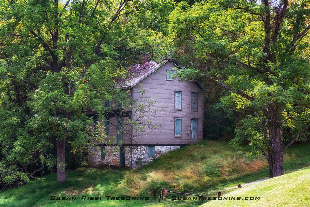
99.1 - Lock & Lockhouse 44
GPS: 39.594812, -77.824918
From the Williamsport Visitor Center, it's a pleasant hike along a watered section of the canal. If you prefer to drive it, Main Street in Williamsport dead-ends at the parking lot for Lockhouse 44.
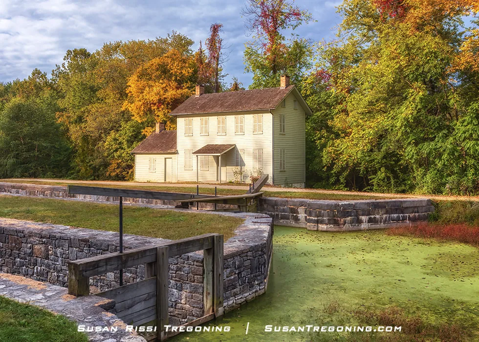
Lock 44 and its two‑story lockhouse stand along a peaceful bend of the canal, framed by autumn color and early engineering craftsmanship.
Lock 44 is unusual on the upper C&O Canal because it still retains all of its original gate hardware, something rarely found upstream beyond Lock 23. Its sluice—the inland channel that carried excess water away during lock‑throughs—is also remarkably intact. While every lock once had a sluice, most were later filled in or left to grow over, making the one at Lock 44 a rare surviving example of how the canal managed water without stressing the lift gates or flooding the banks.
Williamsport endured significant hardship during the Civil War, and Lock 44 was heavily damaged. In 1862, the lock gates, a lockkeeper’s shanty, several nearby structures, and eleven canal boats were burned. The following year, the gates were destroyed again, and part of the lock wall was torn down.
The lockhouse adds another layer of uncertainty to the site’s history. Although a contract for a house was issued when the canal first opened, it was never built. Many have assumed a lockhouse stood here by the early 1850s, but no evidence suggests that a house was destroyed in either of the wartime fires. In 1867, the C&O Canal Company again directed that a house be constructed at Lock 44. It may be the structure that stands today, but the exact date remains unknown. When the canal went into receivership, a house was already present, and the earliest photographic proof dates to 1901.
Harvey Brant, the last lockkeeper at Lock 44, moved into the lockhouse in 1915 with his wife and two young daughters. He operated the lock until the canal closed in 1924 and continued living in the house until 1961. After the Brant family moved out, the lockhouse sat empty.
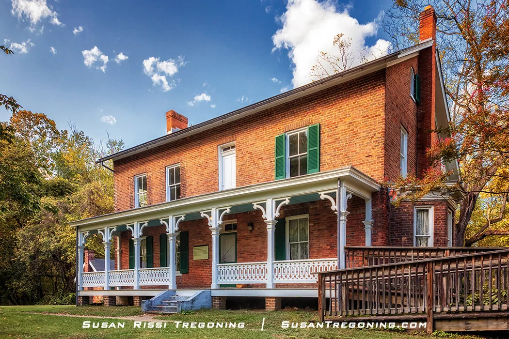
99.7 - Williamsport - C&O Canal Visitors Center
Cushwa Warehouse - 205 West Potomac, Williamsburg, Maryland
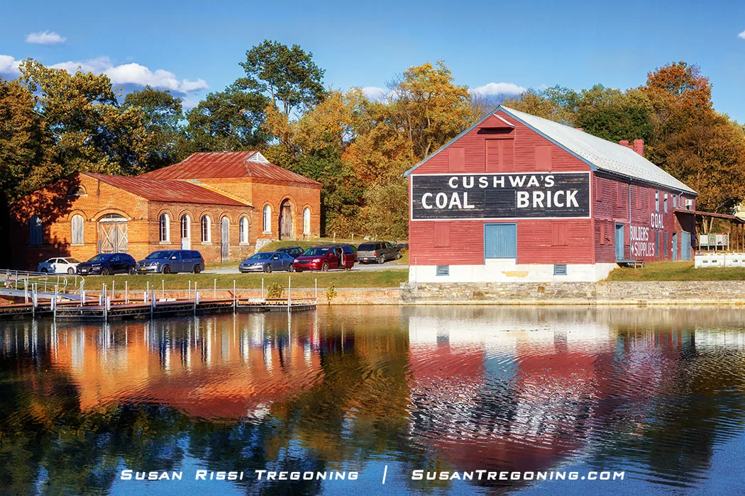
Cushwa’s Warehouse stands along the Cushwa Turning Basin, its brick walls and painted signage recalling the canal era when goods were loaded, stored, and shipped through Williamsport.
The C&O Canal made it to Williamsport in 1834. The town prospered with the new trade route, which now opened from Williamsport to Georgetown.
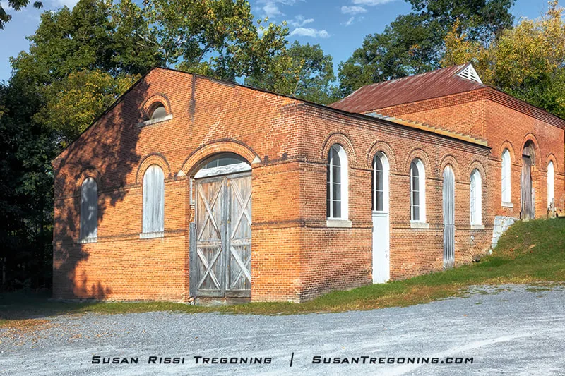
The Cushwa Coal and Brick Warehouse, built between 1790 and 1810, predates the C&O Canal. Sometime after the canal opened, Victor Cushwa and his partner Charles Embry purchased the warehouse. By the 1880s, Cushwa was the sole owner. The Cushwa Warehouse was used to store coal, brick, iron, cement, and plaster. It operated as a warehouse until the 1970s.
The Cushwa Turning Basin was one of the few places along the C&O Canal where canal boats could completely turn around. During the canal's heyday, boatmen lined up their cargo boats up and down the canal, waiting to load and unload cargo at the Cushwa Warehouse, where they could pull right up to the warehouse doors.
The historic trolley barn beside Cushwa’s Warehouse stands as a quiet reminder of the C&O Canal’s working past, where transportation, industry, and community once converged along the waterway.
The trolley began service in Williamsport in 1896. The building, just up the hill from Cushwa's Warehouse, is the Trolley Barn. This barn was a power generating station for the trolley line between Williamsport and Hagerstown. Steam-powered, the station drew water from the Conococheague Creek to generate electricity. The trolley line expanded quickly, only lasting a year in this location before a more significant power station was built in Hagerstown to replace it. Cushwa, who had initially donated the land to the trolley company, took over the station for additional warehouse space after it moved.
The Conococheague Aqueduct, the second largest of the C&O Canal’s eleven aqueducts, spans the river with sunlit stone arches and calm reflections.
The Conococheague Aqueduct originally cost $43,283.78 to build with local limestone in 1835. It is the only rewatered aqueduct along the C&O Canal and is fully operational, allowing a canal boat to pass through. The Cushwa Visitors Center offers canal rides in an 1890s replica launch boat during the Summer.
As a boatman would say, the "wall has gone out" several times. It was damaged during the Civil War when Mosby's Raiders took it out. In an incident in 1920, Captain Myers, returning to Williamsport after dropping off a load of coal in Cumberland, bumped the wall with boat #73. He saw the aqueduct wall shutter and had enough time to yell for them to release the mules before the wall collapsed. He could jump safely as the boat fell through the break and into the creek. After being repaired once again, the flood of 1924 destroyed it. Since the C&O Canal Company was no longer in business, the aqueduct sat in disrepair until the 2017 restoration work returned it to its 1920s appearance.
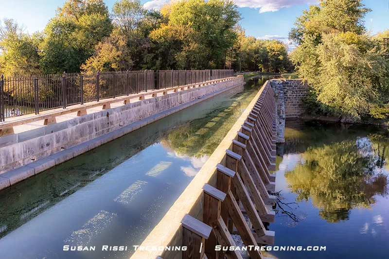
A view down the Conococheague Aqueduct reveals how this stone‑walled structure once carried canal boats high above the river, guiding traffic along the C&O Canal.
The Conococheague Aqueduct is on the right side of the Cushwa Turning Basin
On the left side of the Cushwa Basin, you can visit this old railroad lift bridge across the C&O Canal.
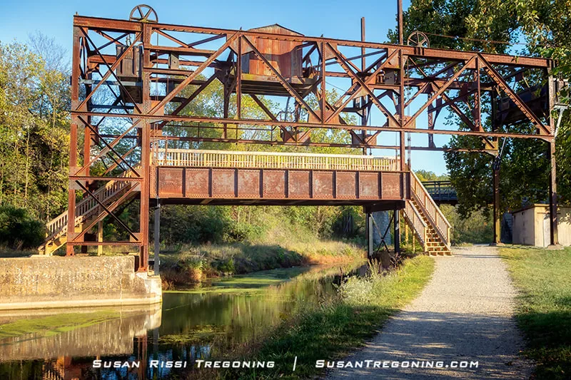
The West Maryland Railway Lift Bridge, once part of the rail line, now serves as the pedestrian crossover to reach the C&O Canal towpath.
When the Western Maryland Railway reached Williamsport, Maryland, in 1873, there was a clash of transportation modes, with the railroad tracks needing to cross the canal. In 1923, the Western Maryland Railway finally built this unique lift bridge, which allowed canal traffic to travel below the bridge when it was up. When lowered, the Western Maryland Railway could use the rail spur to deliver coal to the nearby Paul Smith Power Plant between the canal and the river. The lift bridge was only used for a year. In 1924, the C&O Canal Company closed, and Williamsport saw its last canal boat.
In 2016, the lift bridge was raised to expand the canal boat ride from the Cushwa Basin. Access from the Visitors Center to the towpath was lost then, and the stairs and platform had to be added to the bridge. A park on the towpath side of the canal offers a few handicapped parking spots for those unable to climb the stairs.
106.2 - Location of the Middlekauff's Dam/Labor Riot
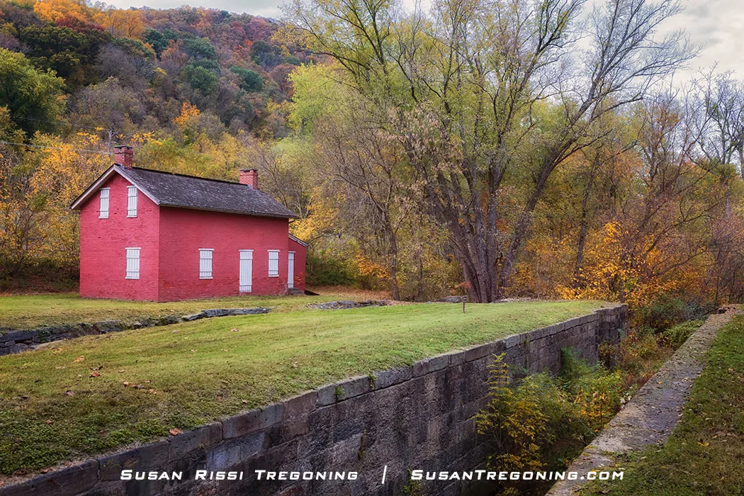
106.6 - Dam 5, the Guard Lock 5 & Lockhouse
10746 Dam Number 5 Road, Clear Springs, Maryland
Dam 5 once powered nearby mills and helped maintain water levels for the C&O Canal; today its cascading flow and brick powerhouse create one of the canal’s most picturesque scenes.
When first built in 1835, Dam 5 was originally constructed of wood and stone but frequently needed repair due to flood damage. In 1860, the C&O Canal Company replaced it with a permanent masonry dam.
Canallers called the water created behind Dam 5 Little Slackwater. Canal boats navigated on the dammed-up Potomac River for about a half mile and returned to the canal at Lock 45. This was a more economical solution than blasting the solid rock walls for an access point to the canal. It also guaranteed there was always enough excess water to keep the canal watered in times of drought.
Across the river is a hydroelectric plant. Originally a mill, Edward Colston had an agreement with the C&O Canal Company to use the water to run his sawmill and gristmill. The Colston family ran the mill until the late 1870s. The Potomac Pulp Company eventually purchased the mill, converted it into a paper mill, and ran it from 1887 until 1891. After the paper mill closed, it became a hydroelectric power plant.
The Dam 5 Lockhouse and its adjacent Guard Lock mark an important control point along the C&O Canal, preserved today with its stone foundation, footbridge, and tree‑lined setting.
The lockhouse high on the hill was the home for the man that managed Dam 5 and Guard Lock 5. It is not the lockhouse for lock 45, as many mistakenly believe.
On the left side of the image, at the base of the hill, is the Guard Lock. At one time, the Guard Lock could be opened and shut to regulate the water flow into the canal, but it is now filled with concrete to keep the Potomac River from flooding the area since the canal here is also filled in.
Canal boats traveling upstream passed through the Dam 5 guard lock and entered the Potomac River or Little Slackwater until they reached Lock 45, half a mile away, where they reentered the canal.
107 - Lock 45
107.2 - Lock & Lockhouse 46
GPS: 39.6157229, -77.9262321
Everything I read about this lock house said there was parking on site, but the gate was closed across the very steep road down to the lot and it was obvious it had not been opening in quite awhile. Look for a closed gate on a curve; we drove past it several times. There is enough space for one car to pull off. Dam 5 would be the next closest parking to hike in.
Lock 46 and its whitewashed lockhouse mark an important stop along the C&O Canal, preserved today with its stone chamber, red roof, and surrounding forest.
After exiting the Little Stackwater at Lock 45, about 300 yards downstream from Lock 46, the mules needed a place to switch from the river towpath to the canal towpath.
The transfer happened at Lock 46. The stone ramps on either side of the canal and arch are what remains of a mule bridge. The arch on the left was once part of the sluice.
The Lockkeeper for Lock 46 also operated Lock 45.
108.2 - Ruins of Charles Mill
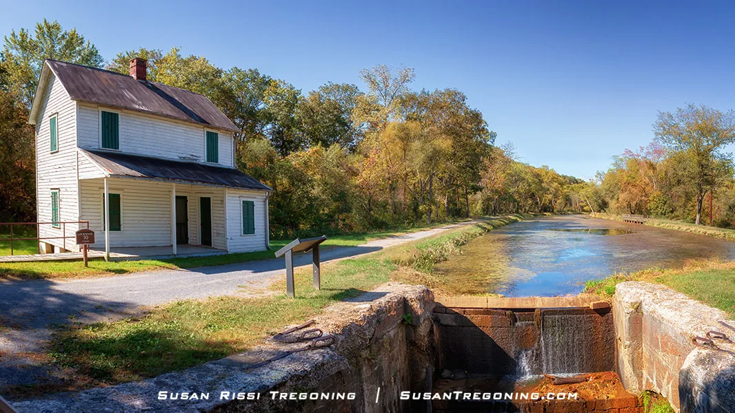
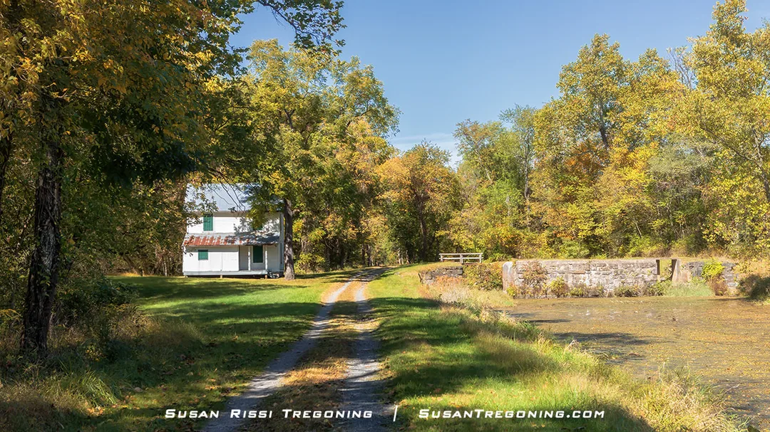
109 - Four Locks
GPS: 39.6147251, -77.9471927
Constructed 1836-1838, Locks 47 through 50 were built within a ½ mile stretch of each other because there was a 33-foot change in elevation from Lock 47 to Lock 50.
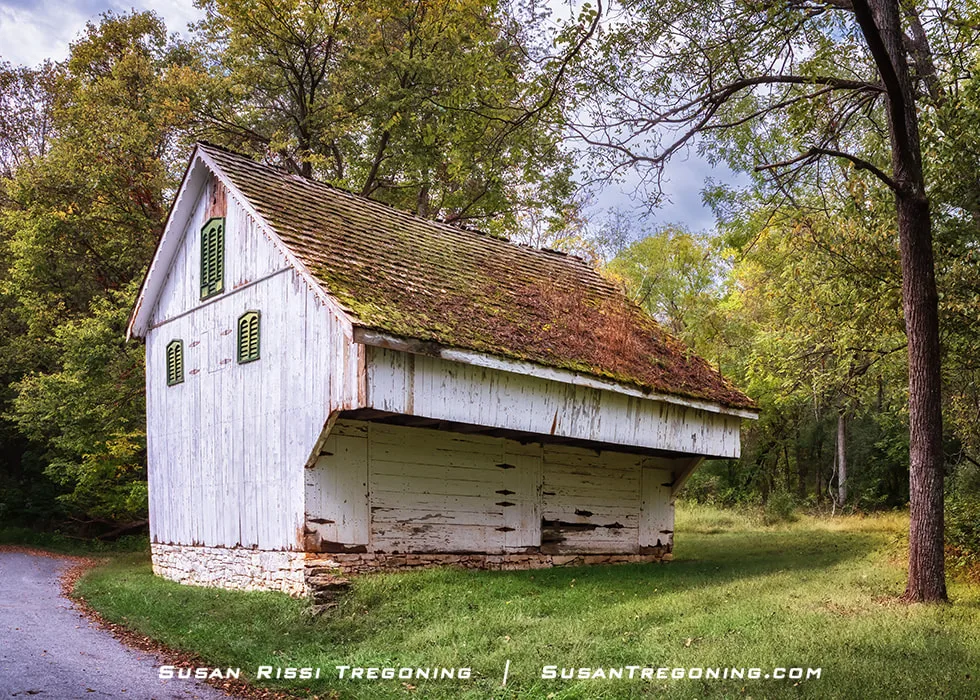
A small but busy community called Four Locks grew up around this set of locks. The town had two general stores in its heyday—two warehouses where the canal boats loaded and unloaded near locks 49 and 50. A dry dock to repair boats at lock 47. A mule barn, post office, one-room schoolhouse (still standing), and many houses. When the C&O Canal closed in 1924, most everyone moved on to find jobs elsewhere.
Lockhouse 49 overlooks its stone lock from a hilltop perch, a well‑preserved reminder of life along the C&O Canal.
Most lockkeepers were responsible for only one or two locks along the C&O Canal, but at Lockhouse 49, the keeper was responsible for all four locks. Four generations of the Taylor family lived in Lockhouse 49 and shared those lock-keeping duties.
Lockhouse 49 is part of the Canal Quarter Program.
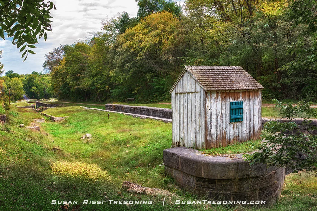
The last remaining Watch House on the entire C&O Canal stands beside its stone lock, a rare survivor of the canal’s early safety and operations system.
The lock tender for Four Locks was in charge of Locks 47 through 50. His home, lockhouse 49, was not built alongside the Canal like other lockhouses. Someone had to be on call 24/7 no matter the weather, so this tiny watch house or watch shanty was constructed atop the hill at Lock 50, making it easy to watch for boats. The shanty has a window on either side. The lock tender could see down past Lock 47 and arrivals to Lock 50 from 51.
Once part of the canal community, the Flory House now stands empty and fading, its stone lower level and boarded windows slowly giving way to the surrounding forest.
This boarded-up house is called the Flory House. Located near Lock 49, the building was either the Four Locks Post Office and postmaster's home or the Post Office sat alongside the house from 1878-1903. In that time frame, eight different postmasters lived here. Alex Flory was postmaster from 1882-85, and then his wife, Mary, took over. Mary Flory was the only female postmaster who served the longest term, from 1885 to 1903.
Today, the Four Locks area is recreational in the Little Slackwater above Dam 5. It is popular for boating, fishing, and picnicking. The boat dock has a large parking lot.
112.2 - Big Pool
A wide lake-like area once an ancient river channel. C&O utilized this natural water feature instead of digging a canal through here. It is said to be a great wildlife area.
Three parking options near Big Pool:
Fort Frederick State Park
11100 Fort Frederick Rd, Big Pool, MD
Big Pool Parking
GPS: 39.609846, -78.004589
Western Maryland Rail Trail
GPS: 39.623898, -78.0171195
116 - Licking Creek Aqueduct
No easy access
122.7 - Lock 51 & ruins of a lockhouse
122.8 - Hancock - C&O Canal Visitors Center
Bowles House - 439 East Main Street Hancock, Maryland
Hancock, one of the oldest settlements in Maryland, is a unique place with a rich history. It is located in the state's narrowest part; only two miles separates Pennsylvania from West Virginia. In the early 1700s, it was a trading post, and George Washington was a frequent visitor to the area. In the early 1800s, it grew into a transportation route. When the C&O Canal came through in the 1830s, Hancock became a booming commercial center with an influx of immigrants to the area.
Built in the 19th century, the Bowles House remains one of the canal’s best‑preserved residences, complete with its brick chimneys, green shutters, and graceful columned porch.
The historic Bowles House, located on the east side of Hancock, was built in the 1790s. This farmhouse witnessed the arrival of the C&O Canal not far from its doorstep in the mid-1830s. The house’s residents sold goods and produce to the canawlers (canal boatmen) who passed through Lock 52 and the Tonoloway Aqueduct. Today, this lovely old home is the Hancock C&O Canal Visitor Center.
The Tonoloway Aqueduct, constructed between 1835 and 1839, was constructed of limestone extracted from the Tonoloway Creek, a 31-mile tributary of the Potomac River. The cement for the aqueduct came from nearby Captain Hooks Mill in West Virginia, but during a water shortage in 1837, it had to be imported from Boteler’s Mill and Baltimore.
Built to carry the C&O Canal over Tonoloway Creek, this historic aqueduct still stands amid dense foliage, its stone arches and metal supports marking an important engineering point along the route.
Lock 52 and Tonoloway Aqueduct are just a short walk from the visitor center.
130.1 - Lock 53
130.7 - Cohill Station Parking
GPS: 39.645494, -78.2515301
134.0 - Lock 54 & foundation of the lockhouse
134.2 - Remains of Dam 6, Guard Lock 6 and Lock 55
This was the terminus from 1842 - 1850 when the canal was completed to Cumberland. Guard Lock 6 is filled in
1.8 miles from parking
Western Maryland Rail Trail Parking Lot
Pearre Rd.
GPS: 39.6361864,-78.325403
136.2 - Lock & Lockhouse 56
.3 miles from parking
136.6 - Sideling Hill Creek Aqueduct
139.4 - Lock 57
141 - Fifteen Mile Creek Aqueduct
11741 High Germany Rd, Little Orleans, Maryland
Built to carry the C&O Canal across Fifteen Mile Creek, this stone aqueduct remains one of the most picturesque engineering landmarks along the route.
The Fifteen Mile Creek Aqueduct is a small single-arch aqueduct that is still in excellent condition, considering its age of a century and a half.
Construction started in 1838, but the C&O Canal Company ran out of money in 1842 and sat unfinished until 1850. It was a site of labor riots and unrest that led to bloodshed and many laborers being blacklisted. There are many canal builders buried in the nearby St. Patrick's Cemetery.
The aqueduct was constructed out of hard flint stone quarried on the West Virginia side of the Potomac River at Sideling Hill.
The aqueduct can be seen from the boat ramp at the Fifteen Mile Creek Campground in Little Orleans, Maryland.
144.0 - Lock 58
146.5 - Lock 59
149.6 - Lock 60
153.1 - Lock 61
154.1 - Lock 62
154.5 - Lock 63 1/3
154.6 - Lock 64 2/3
154.7 - Lock 66 1/3 -
Notice that Lock 65 is missing.
Lock 65 - The Missing Lock
To save money, 10-foot lifts were used instead of 8-foot lifts. Lock 65 was not needed. Since contracts were already in place for locks upstream, they could not change the numbering.
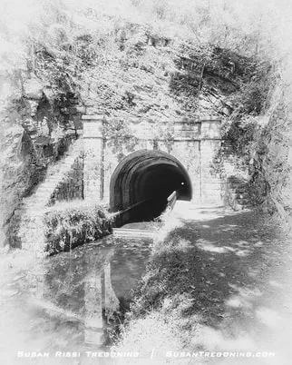
155.2 Paw Paw Tunnel
GPS: 39.544616, -78.460582
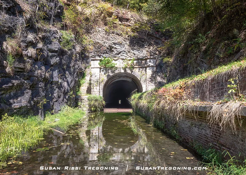
Built to carry the C&O Canal through the mountain, the Paw Paw Tunnel’s arched entrance and stone retaining walls remain a striking reminder of the canal’s ambitious construction.
Paw Paw Tunnel is considered an amazing engineering feat and the most notable landmark on the Canal.
The tunnel, at 3,118 feet long (3/5 of a mile), took 5,800,000 bricks to build, and it cut 5 miles off the canal’s length by cutting through the mountain. Originally estimated to cost $33,500 and take two years, C&O finally completed it after 12 years and $566,500. The tunnel nearly bankrupted the Chesapeake and Ohio Canal Company. The tunnel is most likely one of the reasons C&O never completed the canal to the Ohio River at Pittsburgh.
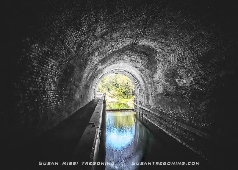
Light from the far portal illuminates the brick interior of the Paw Paw Tunnel, revealing the narrow canal channel and towpath that once carried boats through the mountain.
The Paw Paw Tunnel has a colorful history. Race Riots between the German, English, and Irish workers, strikes, discontent, and eventual arrests defined its twelve years of construction.
When C&O eventually completed the canal, it was only wide enough for one boat at a time. Bottlenecks would occur, causing fights between the boatmen refusing to yield the right-of-way. Even though the rule was that the downstream-headed boat would back up and leave the tunnel to allow the upstream boat to proceed, they would sometimes refuse. Once, a standoff went on for days until the boatmen built a fire upstream to smoke them out.
If you plan to walk through the tunnel, a flashlight is necessary.
161.7 - Lock 67
.6 mile hike from Town Creek Aqueduct parking lot.
162.4 - Town Creek Aqueduct
parking on site 39.5237668, -78.5433002
164.8 - Lock 68 & South Branch of the Potomac River
166.5 - Lock 69
166.7 - Oldtown
GPS: 39.540269, -78.6125302
There is a large parking lot at Lock 70.
A four-mile stretch of the C&O Canal through Oldtown, Maryland, was rewatered in the 1940s and 50s. It is known as the Battie Mixon Pond in honor of the Natural Resources Officer who led the community's rewatering effort.
There are three locks within a half-mile stretch of the canal here, Locks 69-71. They are the last of the composite locks along the Canal. By the time the Canal construction reached Oldtown, the C&O Canal Company was in financial trouble and struggled to get good-quality stone to the Canal's far upstream locks. They allowed contractors to use whatever stone they could find and augment the construction with wood.
At Milepost 70, the lock and its white‑painted lockhouse remain a beautifully preserved reminder of daily life and work along the C&O Canal.
Lockhouse 70 sits right alongside Green Spring Road in the center of Oldtown, Maryland. This two-story white framed lockhouse is sometimes open on the weekends during the summer.
Lock 70 is in good condition. In 1906, a fire destroyed the Green Spring Road covered bridge over the canal and damaged the lock, which needed to be rebuilt.
This lockhouse is between two other very historical sites:
Michael Cresap House is where Green Spring Road Ts is at Opressa Street.
Michael Cresap was the first white man born in Allegany County. He built the house in 1764, making it the oldest existing home in the county.
Last privately owned interstate toll bridge is just a short distance past the lockhouse. It connects Oldtown to Greenspring, West Virginia.
Once home to the lockkeeper who managed this stretch of the canal, Lockhouse 71 and its adjacent stone lock remain a peaceful reminder of daily life along the C&O.
Lockhouse 71 is at towpath mile 167, just a very short distance upstream from Lock 70. Lock 71, one of the remaining composite locks, had lock pockets that were later replaced with concrete.
173.3 - Spring Gap Parking Lot
39.5643168, -78.7192646
173.5 - Patterson Creek Bridge ruins
174.2 - Steam Pumping Station
174.4 - Lock & Lockhouse 72 & Blue Spring
Largest springs east of the Mississippi.
175.4 - Lock 73
175.5 - Lock 74
It has a 10-foot lift instead of the average 8-foot lift
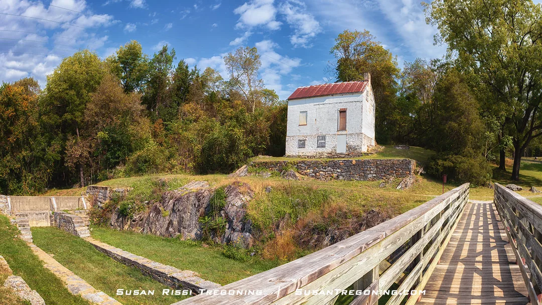
175.7 Lock & Lockhouse 75
GPS: 39.587555, -78.741766
Once home to the lockkeeper who managed this stretch of the canal, Lockhouse 75 and its stone lock remain a beautifully preserved piece of C&O Canal history.
Lock 75 is the final and farthest lock West on the C&O Canal. This lock has a ten-foot lift for a total elevational change of 609.193 feet above the Georgetown tidal lock.
Although numbered as Lock 75, there are only 74 locks along the C&O Canal. In an effort to save money toward the end of the project, C&O had several 10-foot lift locks constructed instead of building the standard 8-foot lifts, allowing them to skip lock number 65 in a four-lock sequence. The locks were not renumbered since contracts were in place and construction was underway for upstream locks.
Lockhouse 75 is one of the final blockhouses to be built along the canal and one of the few remaining log cabin lockhouses. It was damaged in the March 1936 flood after the canal had already closed, and then a dust beetle infestation nearly finished off the structure. While the log home sits on its original foundations, only a few original timbers could be used in this 1978 reconstruction.
180.7 - Evitts Creek Aqueduct
184.5 C&O Canal Terminus
Inlet Feeder Guard Locks & Dam 8 Remnants
Cumberland Canal Boat - Behind the Fairfield Inn & Suites
21 North Wineow Street
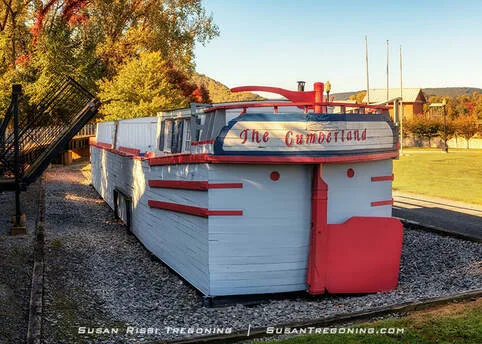
A full‑scale replica of the canal boat Cumberland showcases the design and craftsmanship of the vessels that once carried cargo along the C&O Canal.
The Cumberland is a full-scale replica of a canal boat. Constructed in 1976 as a bicentennial project by the C&O Canal of Cumberland, Maryland, the boat measures 93 feet long and 14.5 feet wide.
When the COCCM began planning this project, no boats or blueprints existed. Canal boats had to be researched and plans recreated before the building could start; the replica cost over $100,000 to complete.
After its dedication on July 11, 1976, the COCCM operated it for 23 years, conducting interpretive boat tours during the warmer months.
184.6 Cumberland - C&O Canal Visitor Center
Western Maryland Railway Station - far right side of building
13 Canal Street, Cumberland, Maryland
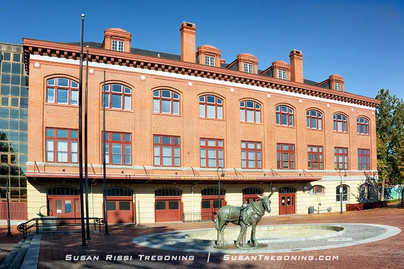
Once a bustling hub for rail travel, the Western Maryland Railway Station now anchors the plaza with its arched windows and the bronze mule statue honoring the canal’s working past.
When the Western Maryland Railway built the Cumberland Station in 1913, they placed it at the northern end of the old Chesapeake & Ohio Canal Basin, which had been filled in as the canal declined in importance. This historic red-brick train depot operated as a passenger station until closing in 1958.
The station underwent a series of renovations in the 1990s. Today, the building is the center of the Canal Place Preservation District. The depot houses offices for the Western Maryland Scenic Railroad, a sightseeing excursion train through the Blue Ridge Mountain Foothills.
There is a wealth of information on the NPS website. Always check the NPS website for closures along the towpath before visiting.
All the visitor centers were closed when I visited. A downloadable park map is available, I never found a map anywhere until reaching my final stop at Great Falls Tavern. Luckily, I planned for that.
I have created a detailed Google map with all the canal locations.
Not every image makes it into my blog. If you enjoyed the photos in this article, please check out my Image Gallery with over 4000 images of locations around the United States.

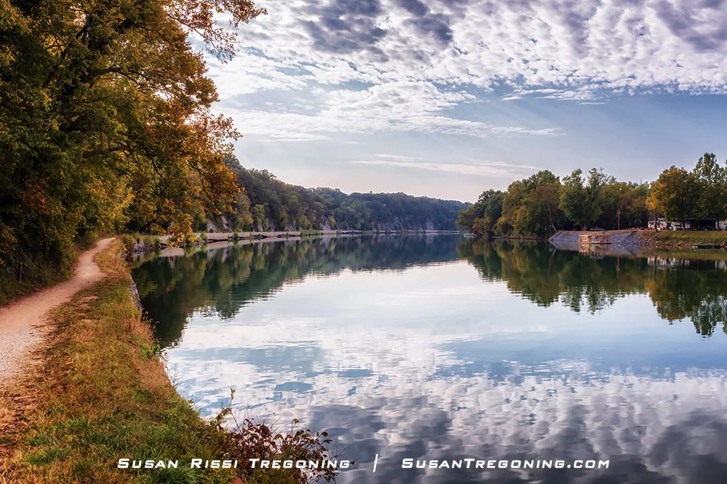
A quiet morning settles over the Cushwa Basin, where historic brick buildings and still water create a moment of calm. This peaceful scene is available as a fine art print for anyone who loves the charm of the C&O Canal.
Fine Art Prints are available for order as print only, framed art, canvas art, metal art, acrylic art, and wood art prints in various sizes. Home Decor and Gift Ideas include shower curtains, throw pillows, towels, totes, phone cases, t-shirts, puzzles, blankets, and more. Worldwide Shipping with a 30-day money-back guarantee.
More of the USA
- A Travelers Musings (1)
- Alabama (1)
- Hawaii (3)
- Illinois (6)
- Indiana (3)
- Iowa (3)
- Louisiana (1)
- Maryland (1)
- Michigan (2)
- Minnesota (4)
- Mississippi (6)
- Missouri (2)
- Montana (1)
- Nebraska (5)
- New Mexico (1)
- North Carolina (1)
- Pennsylvania (2)
- Route 66 (5)
- South Dakota (1)
- Tennessee (1)
- Texas (1)
- Virginia (2)
- Washington DC (1)
- West Virginia (3)
- Wildlife (6)
- Wisconsin (2)
- Wyoming (4)
