Western Trails Scenic and Historic Byway: Landmarks of Nebraska’s Pioneer Past

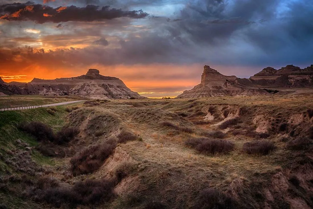
Sunset settles over Scotts Bluff National Monument, where Sentinel Rock and Eagle Rock rise above Mitchell Pass, the same route thousands of Oregon Trail emigrants once followed across the plains.
In western Nebraska, the Western Trails Scenic and Historic Byway follows a 144‑mile stretch of land once crossed by thousands of emigrants heading west. From Ogallala to the Wyoming border, the route unfolds across open prairie and toward the dramatic rock formations that served as landmarks for pioneers nearly 200 years ago. These natural monuments, and the stories they hold, are the focus of this post.
Courthouse and Jail Rock
Five miles south of Bridgeport, Nebraska, along Nebraska Highway 88.
Coordinates: 41.59694° N, 103.11583° W
Courthouse and Jail Rock emerge from the rolling prairie, guiding Oregon Trail travelers toward the high plains and marking the start of the great western ascent.
Located in the Platte River valley, just outside of Bridgeport, Nebraska, Courthouse and its smaller neighbor Jail Rock were the first two monumental rock features that the pioneers encountered on their journey west.
This was an important crossroads where two major Oregon and California Overland trail trunks merged. Because of its importance, a Pony Express station was also located here.
Rising 340 feet above the North Platte River Valley, the most significant rock formation was called the “Castle” by some but “Courthouse” by the people who traveled from Missouri because they claimed it resembled the Saint Louis Courthouse.
There was never any disagreement about the name Jail Rock for its smaller counterpart since one-room jailhouses were common out west at the time. The name Courthouse Rock finally stuck since you can’t have a jail without a courthouse nearby.
These monuments are the erosional remnants of an ancient plateau. They are composed of Brule clay, Gering sandstone, and volcanic ash. Although they have eroded somewhat since the pioneers' days, they are still impressive formations. They are listed in the National Register of Historic Places and the Nebraska Natural Areas Register.
Visitor Information for Courthouse and Jail Rock
Courthouse and Jail Rocks are open to the public year‑round during daylight hours. Reaching the formations requires driving an unpaved road that is suitable for most vehicles when conditions are dry. At the end of the road, a hiking trail leads toward Courthouse Rock. This trail once continued to the summit, but significant erosion has removed large sections, making the upper route unsafe. Use extreme caution when hiking. There are no tourist facilities or staff on site, so visitors should plan accordingly.
Chimney Rock
9822 County Road 75, Bayard, Nebraska

Cattle graze beneath Chimney Rock on the Nebraska prairie, a scene echoing the landscape Oregon Trail travelers would have recognized on their journey west.
Located about 12 miles to the northwest as the crow flies from Courthouse and Jail Rocks, near what is now the town of Bayard, Nebraska, Chimney Rock is one of the most picturesque landmarks along the Oregon, California, and Mormon trails.
Towering 325 feet above the valley, it sits on a conical base, and the spire alone is 120 feet tall. Chimney Rock is a natural geologic formation composed of layers of volcanic ash and Brule clay. It is the remnant of the erosion of the bluffs at the edge of the North Platte River Valley.
General Joel Palmer, who led a surveying party in 1845, described it as having the...
appearance of a haystack with a pole running far above its top.
The name "Chimney Rock” more than likely originated with the early fur traders. It was also called Chimney Rock and Chimney Tower for a time. Earlier on, it was referred to as Elk’s Peak and Elk Brick, which were more than likely variations of the Lakota Sioux’s name for it, which roughly translated to “elk penis.”
The first recorded mention of "Chimney Rock" was in 1827 by Joshua Pilcher, a fur trader and owner of the Missouri Fur Company based in St. Louis. Pilcher was journeying up the Platte River to the Salt Lake Rendezvous of the Rocky Mountain fur trappers when he spotted Chimney Rock.
By the time the pioneers followed this path, Chimney Rock was so famous that it was mentioned in most of their diaries, with some travelers reporting that it was visible from almost 40 miles away.
This was an important landmark because it signaled to the pioneers that they had reached the end of the prairies. Their journey going forward would become more difficult; the trail would be more rugged and steep as they approached the Rocky Mountains.
Chimney Rock was designated a National Historic Site in 1956. There is now a Museum and Visitor Center located here.
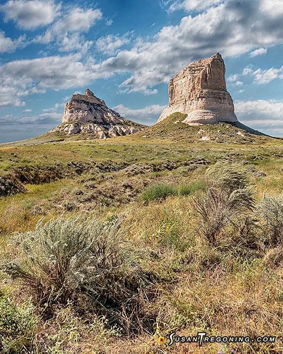
Robidoux Pass
Coordinates: 41.81497° N –103.85384° W
Looking toward the backside of Dome Rock, Crown Rock, and Sentinel Rock from Robidoux Pass—a once‑busy emigrant route that fell out of use after travelers shifted to the shorter, easier Mitchell Pass.
Robidoux Pass, or Roubadeau Pass, is the first of two historic passes through the Wildcat Hills. This trail forced emigrants to swing 30 miles south away from the North Platte River to access a natural gap passing through the Wildcat Hills.
The earliest travelers to use this pass were most likely fur traders and missionaries between the 1820s and the 1830s. The first transcontinental wagon train to pass through was the Bidwell-Bartleson Expedition in 1841. This expedition was comprised of 80 emigrants bound for Oregon along with the Catholic missionary Father DeSmet. Robidoux saw its heaviest use between 1843 and 1851 during the Oregon Migration and the California Gold Rush.
Robidoux almost seems to be forgotten. There are no fancy monuments, and none of the historic buildings remain. Along this gravel road, you will find the reconstructed Robidoux Trading Post, a few wagon ruts, and several markers that point out the original trail. A couple of pioneer graves can also be seen along the trail.
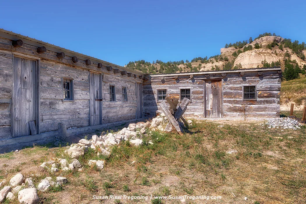
The recreated Robidoux Trading Post rests in a quiet clearing below the Wildcat Hills, representing the frontier outpost that once served Oregon Trail travelers moving through Robidoux Pass.
While no enduring history of the Robidoux Trading Post exists, this building has been recreated through archaeological research and diary entries made by the travelers who passed through the area. This recreated post was built from 100-year-old, hand-hewn logs on its original site.
One emigrant described this post as:
a log shanty with a blacksmith’s forge on one end and a grog shop on the other.
Other trading posts are known to have existed near the pass at that time, but Robidoux’s is the one most often mentioned in diaries.
Located just east of the trail, this trading post was established in 1851 by a French family named Robidoux, who were engaging in free trade with the Plains Indians. The Robidoux Brothers: Joseph, Antoine, Louis, Michael, and Isadore visited here and farther west, trapping and trading with many tribes as early as 1822. The trading post, sometimes referred to as the “winter quarters,” followed an earlier trading post and blacksmith shop just north of this location.
Robidoux sold various goods and provided blacksmith services for travelers. Research indicates that Antoine, son of Joseph III, resided here as the post clerk with his Indian wife and children until 1853.
Robidoux Pass was designated as a National Historic Landmark in 1961.
While a little tricky to locate, this 23‑mile loop on Carter Canyon Road and back on Robidoux Road is absolutely worth the drive.
Finding the Robidoux Trading Post
- From Gering, take Hwy 71 South for about 2 miles.
- Turn right onto Carter Canyon Road / County Road S.
- Continue 8 miles; the recreated Robidoux Trading Post will be on the left.
Continuing to Robidoux Pass
- Stay on Carter Canyon Road past the trading post.
- Follow the road until it reaches a T‑intersection.
- Turn right onto Summit Ranch Road.
- Summit Ranch Road continues straight and becomes Robidoux Pass Road, leading you through the historic pass.
Road Conditions & Safety
- Carter Canyon Road turns to gravel as you approach the pass.
- The route is suitable for most vehicles when dry, but can become rutted or muddy after rain.
- The area is remote, with no facilities and limited cell service, visitors should plan accordingly.
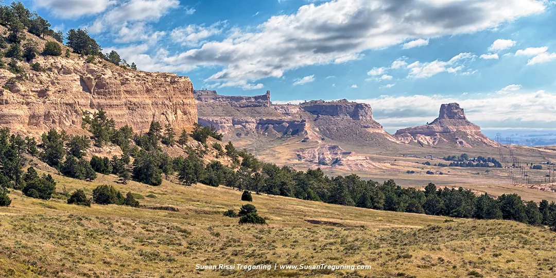
Scotts Bluff National Monument
190276 Old Oregon Trail, Gering, Nebraska
Thanks to the efforts of the US Army, Mitchell Pass, a much shorter route, was created to pass through the center of Scotts Bluff. It opened in 1851. Wagons had not been able to pass through this pass until then, and once this happened, the Robidoux Pass was no longer used.
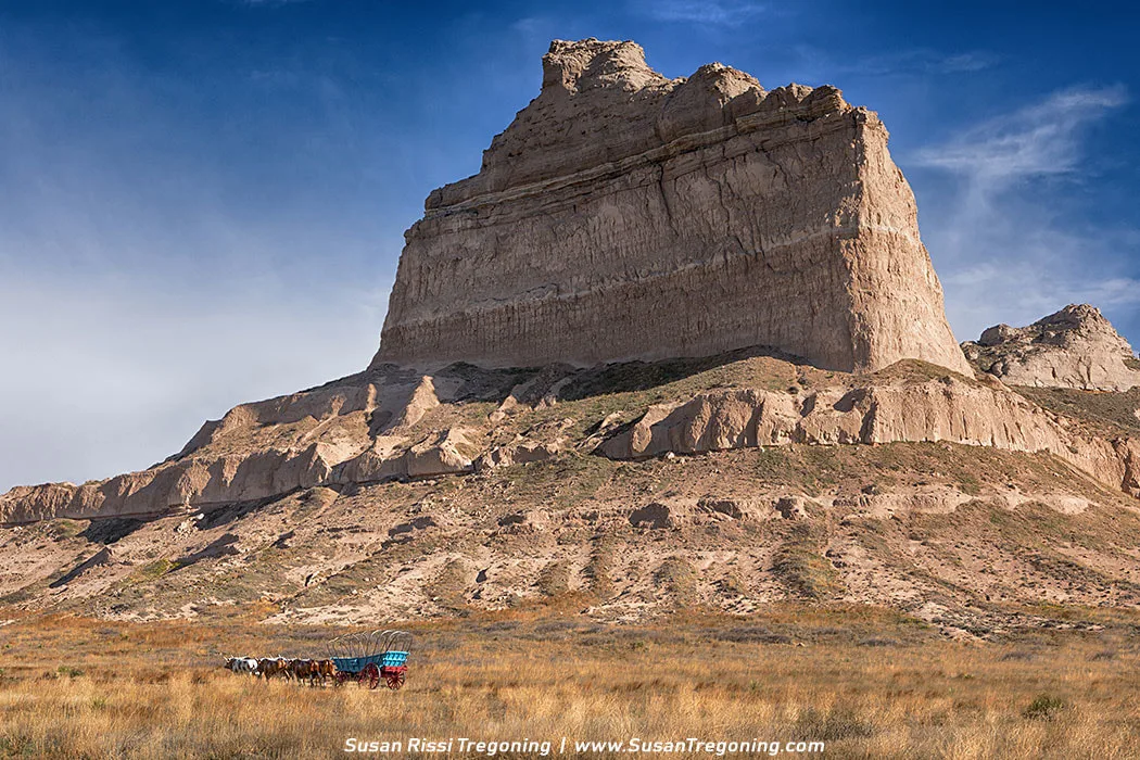
A pioneer wagon stands beneath Eagle Rock Bluff at Mitchell Pass, inviting visitors to relive the history of Scotts Bluff amid sweeping views and deep trail heritage.
Scotts Bluff is the second most referenced landmark on the Oregon, Mormon, and California trails after Chimney Rock. Rising over 800 feet above the plains at its highest point, Scotts Bluff was a significant milestone for many wagon trains and was gazed upon with a great sense of accomplishment. After two months and 600 miles of travel through “the Great American Desert,” as the semi-arid grasslands of Nebraska were known in the mid-1800s, reaching this point indicated that 1/3 of their journey West was completed. They would now be entering the foothills of the Rocky Mountains.

High above the North Platte River at Scotts Bluff, the landscape opens to the valley floor where emigrant wagons once rolled westward. Look closely at the flat ground below and the faint wagon ruts become part of the story again.
Both the Oregon and Mormon Trails paralleled the North Platte River. This river is non-navigable, and the pioneers knew it as a much wider and more dangerous river than it is today. Covered wagons passed Scott’s Bluff on both sides of the river, but they could not get close for fear of getting caught up in silt, gravel, and quicksand. This stretch of Badlands and Scott's Bluff was completely impassable.
Look closely at the image above. On the right side of the image, you can see wagon ruts.
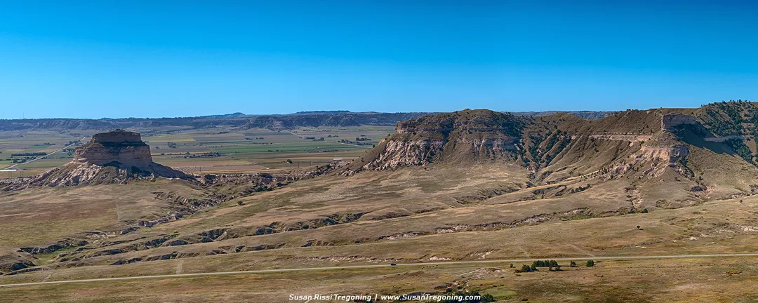
A sweeping panorama of Scotts Bluff frames the massive form of Dome Rock, a landmark that guided generations of westbound travelers across the Nebraska plains.
Few pioneers who reached Scotts Bluff ever scaled the cliffs to see these amazing aerial views. This gives an interesting perspective of the difficulties these pioneers faced driving a wagon train through this area.
Part of the Wildcat Hills, Scotts Bluff is an isolated remnant of the ancient high plains. Twenty million years ago, the surfaces of the plains surrounding the bluff were the same height as the bluffs. About five million years ago, the Platte River and its tributaries began to erode the soil and rock, creating canyons that grew wider and wider.
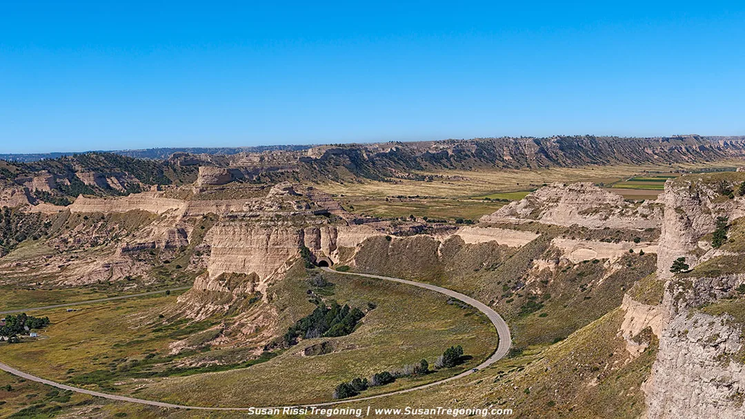
Rising toward the summit of Scotts Bluff, the road curves through stone and sky, opening to the vast beauty of Mitchell Pass and the Nebraska plains beyond.
From Scott's Bluff, it was a race against time to get across the Rocky Mountains before cold weather set in. The pioneers faced even more hardships on the way. Wagons began to break down. Food supplies diminished. Cattle and horses gave out. Many emigrants died along the way.
Not every image makes it into my blog. If you enjoyed the photos in this article, check out the Nebraska Collection for more pictures of this beautiful state, or visit my Gallery with over 4000 images of locations around the United States.

Sunset over Nebraska’s rugged bluffs — a timeless view of the Great Plains captured in warm evening light. This fine‑art photograph brings the quiet strength of the prairie into your home, beautifully framed in rich wood with layered mats that echo the land’s natural tones. Perfect for rustic, heritage‑inspired interiors.
Fine Art Prints are available for order as print only, framed art, canvas art, metal art, acrylic art, and wood art prints in various sizes. Home Decor and Gift Ideas include shower curtains, throw pillows, towels, totes, phone cases, t-shirts, puzzles, blankets and more—Worldwide Shipping with a 30-day money-back guarantee.
More USA Travel Ideas
- A Travelers Musings (1)
- Alabama (1)
- Hawaii (3)
- Illinois (6)
- Indiana (3)
- Iowa (3)
- Louisiana (1)
- Maryland (1)
- Michigan (2)
- Minnesota (4)
- Mississippi (6)
- Missouri (2)
- Montana (1)
- Nebraska (5)
- New Mexico (1)
- North Carolina (1)
- Pennsylvania (2)
- Route 66 (5)
- South Dakota (1)
- Tennessee (1)
- Texas (1)
- Virginia (2)
- Washington DC (1)
- West Virginia (3)
- Wildlife (6)
- Wisconsin (2)
- Wyoming (4)
