Autumn on the Bayfield Peninsula: The Wisconsin Lake Superior Scenic Byway
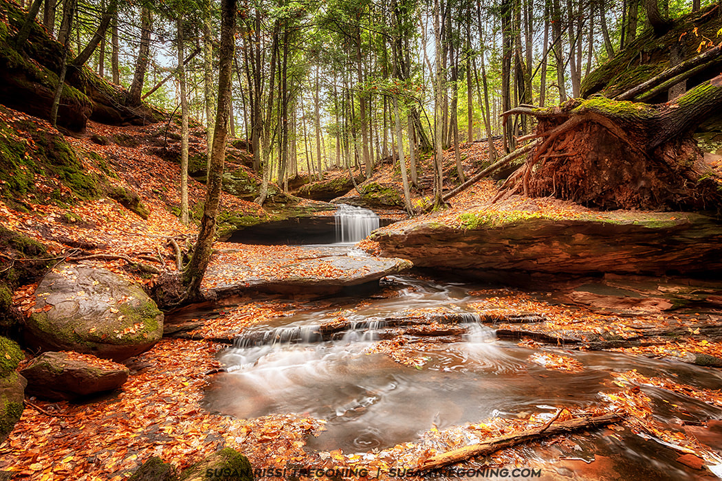
A quiet autumn moment along the gorge at Houghton Falls State Natural Area, where a small cascade slips over layered sandstone and gathers in a shallow, leaf‑strewn pool. Soft light filters through the hardwoods above, highlighting the season’s warm colors against the mossy rock.
In 2018, Wisconsin designated the road through the Bayfield Peninsula as its fourth official scenic byway. Named the Wisconsin Lake Superior Scenic Byway, this 70‑mile stretch of State Highway 13 curves around the South Shore of Lake Superior, offering sweeping views of deep forests, quiet beaches, and the ever‑changing waters of the “big lake.” Along the route, travelers pass through quaint harbor towns rich with historic architecture, old fishing villages, small orchards and fruit farms, and the homeland of the Red Cliff Band of Lake Superior Chippewa. At the heart of it all is Bayfield—the gateway to the Apostle Islands National Lakeshore and the Gaylord Nelson Wilderness Area.
Known primarily as a summer destination, I chose to explore the Bayfield Peninsula in autumn, when most visitors have gone home and the region settles into a quieter rhythm. Many attractions are closed for the season, but it’s the perfect time to reconnect with nature. The fall colors are absolutely electric, and the landscape feels like it’s revealing a side of itself that few travelers ever get to see.
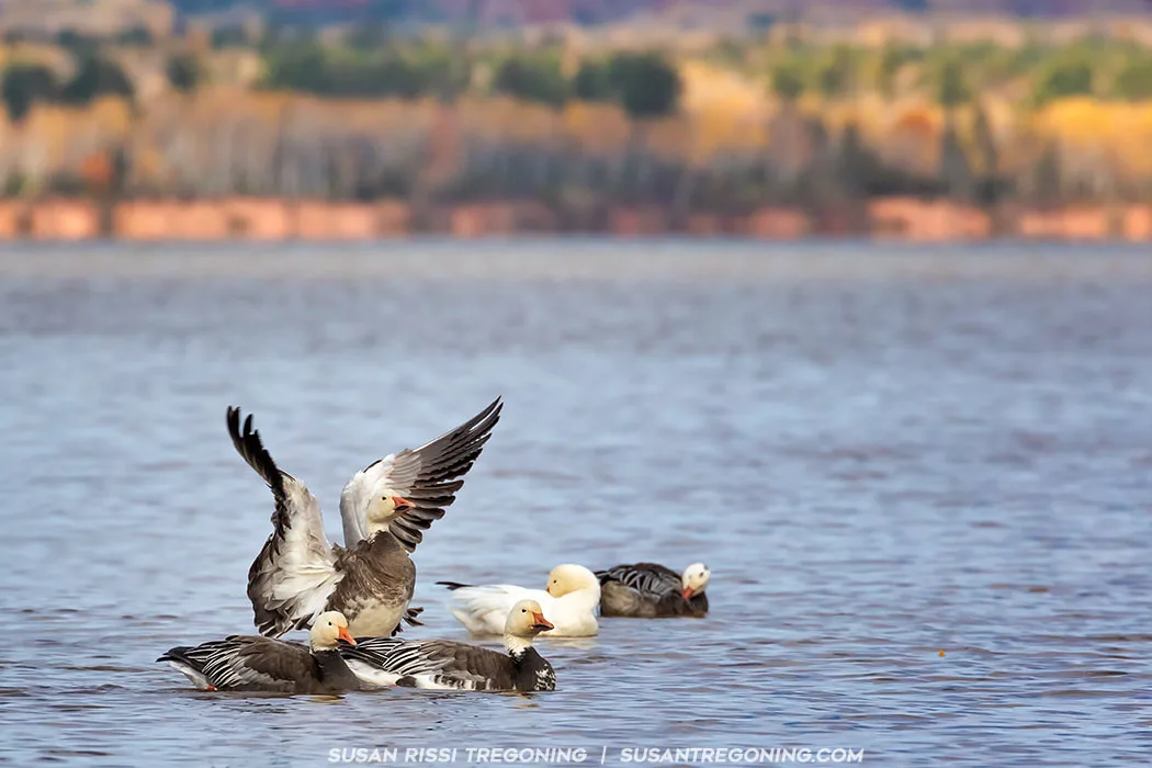
The Snow Geese enjoy a lazy autumn morning on the calm waters of Lake Superior near Whittlesey Creek National Wildlife Refuge in Ashland, Wisconsin. A few drift quietly across the bay while one stretches its wings in the cool shoreline light, framed by the season’s warm colors.
The Wisconsin Lake Superior Scenic Byway begins at Whittlesey Creek National Wildlife Refuge. The Coaster Brook Trout spawn here, and the refuge is one of the twelve freshwater estuaries known as the “String of Pearls” along the Lake Superior shoreline. These protected lands provide important habitat for migrating warblers, and Chequamegon Bay, immediately adjacent to the refuge, is a prime viewing area for migrating waterfowl.
While here, visit the Northern Great Lakes Visitor Center at 29270 County Highway G, Ashland, WI. They are open daily from 9 to 5, and it’s one of the few places offering tourist information during the off‑season. There is also a nice museum inside.
There are kiosks located in each town where you can pick up additional information. I’ll list the location of each—some are kept stocked, others not.
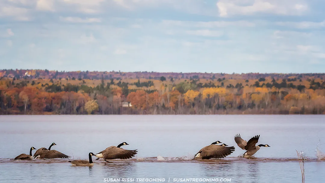
Canada Geese play in the shallows of Lake Superior near Whittlesey Creek National Wildlife Refuge. Though the scene looks like a flurry of landings or takeoffs, none of the birds were actually flying — instead they splashed, chased, and darted around each other in what appeared to be a spirited game of tag.
The 7.5‑mile drive to Washburn parallels the shoreline of Chequamegon Bay and crosses numerous streams flowing down from the highlands. The landscape offers a delightful mix of Lake Superior views, wetlands, and farmland.
Washburn Information Kiosk: Thompson's West End Park
Washburn was a boom town from 1880 to the 1920s. Brownstone was quarried here and shipped all over the country, fueling construction during the era’s rapid growth.
Thompson’s West End Park, located at the west end of town, features a sand beach, an artesian well, and a boat launch.
On the east side of town, Memorial Park offers sweeping Lake Superior views and a stairway down to the lake, making it a peaceful spot to pause and enjoy the shoreline.

Built in 1890 of Lake Superior brownstone, the Bank of Washburn is a fine example of Romanesque Revival design. Located at the corner of Bayfield Street and Central Avenue, the building now houses the Washburn Historical Museum and Cultural Center. It was added to the National Register of Historic Places in 1980.
In town there are three brownstone buildings listed on the National Register of Historic Places:
Bayfield County Courthouse
117 E 5th Street
Washburn Historical Museum and Cultural Center
(Bank of Washburn) – 1 E Bayfield Street
Washburn Carnegie Library
307 Washington Avenue
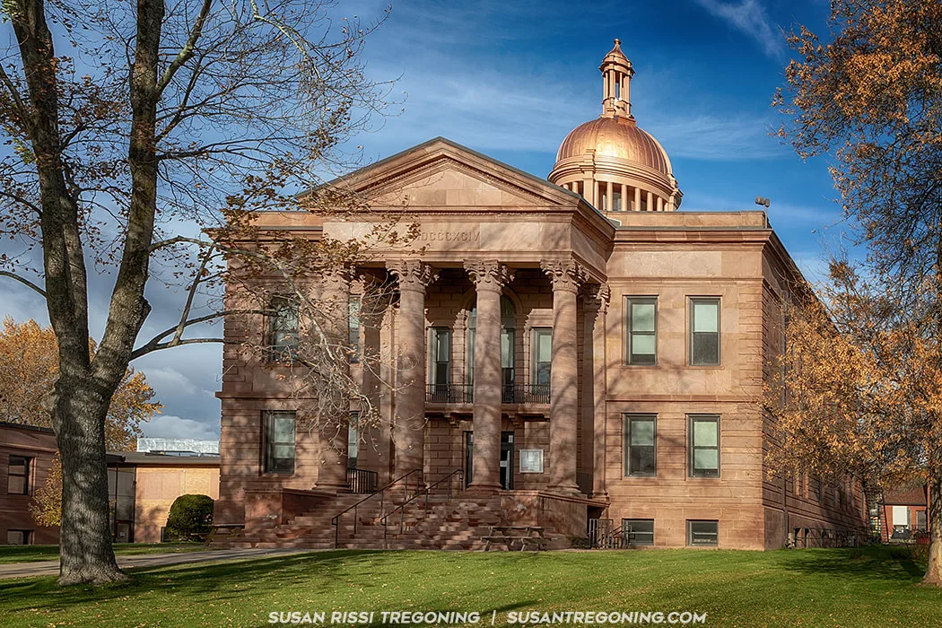
The Bayfield County Courthouse was built in 1894-95 for the cost of $31,737. It was constructed out of Brownstone, reddish-brown sandstone that is made up of quartz sand and found along the south shore of Lake Superior. In fact, the first quarry in the region was established on Basswood Island (one of the Apostle Islands) in 1868. This striking Neoclassical building has a domed cupola, a portico with Corinthian columns at the front entrance and quoins at the corners. It was added to the National Register of Historic Places in 1975.
East 3rd Street in Washburn is a Residential Historic District listed on the National Register of Historic Places. Homes here date from 1885 through 1950. The majority were built between 1916 and 1918 by the DuPont Company for employees of their dynamite plant located just south of town. It was the largest dynamite plant in the world during World War I.
The historic section of 3rd Street stretches between Central Avenue and 6th Avenue. The Washburn Historical Museum and Cultural Center sits at the corner of Central and Bayfield; turn here, and the next road up is 3rd Street—turn right to enter the district.
The district contains 26 single‑family houses, four duplexes, and one apartment building. A few notable homes include:
- 13 E 3rd – The earliest Queen Anne home, built in 1885.
- 23 E 3rd – The second‑oldest home, a Queen Anne Front Gable vernacular, built in 1887.
- 101 E 3rd – A Queen Anne built in 1893.
- 117 E 3rd – A Queen Anne built in 1898.
- 229 E 3rd – A Colonial Revival home built for the DuPont factory superintendent.
Houghton Falls State Natural Area
Located about 1 mile north of Washburn, turn right onto Houghton Falls Road. Continue for about 0.5 miles; the parking lot will be on the right.
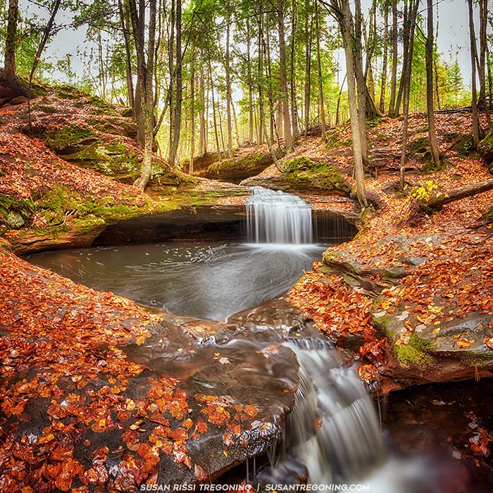
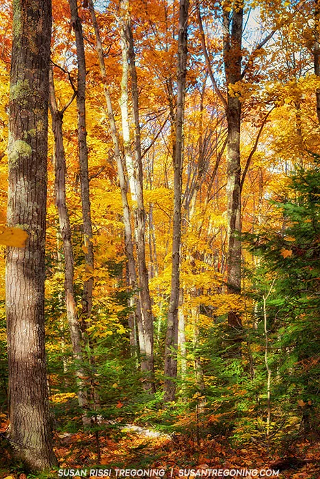
A truly magical location where it’s easy to imagine water sprites and fairies slipping through the shadows. This upstream gorge is shaded by a canopy of trees and overhanging sandstone ledges, with a charming stream winding through the site. Along the way, it forms a series of small waterfalls that spill over layered rock shelves into a quiet cove below.
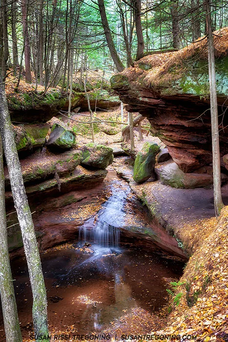
This series of cliffs and caves is called Echo Dells, and it is my favorite part of Houghton Falls.
This is a beautiful and easy hike through the woods.
The waterfall is a low‑flow falls; it only runs after a good rain or during spring snowmelt. If the Dells are dry, the falls will be dry as well.
The Dells are very scenic and, in my opinion, the best part of the hike. It’s not difficult to climb down into the gorge for better views of the cascades in this area.
Farther down the trail, there is a partially obstructed view of Houghton Falls. The gorge walls are extremely steep here, and I was never able to find a safe way to photograph the actual waterfall.
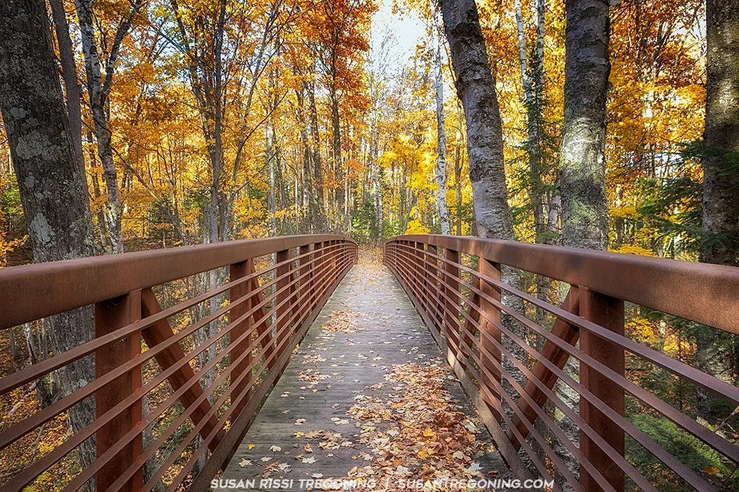
From the falls, it’s only a few hundred feet farther to Lake Superior, and the trail continues all the way to the shoreline.
Bayview Information Kiosk: Bayview Beach Park
Beach frontage runs parallel to the byway for 1.5 miles at Bayview Beach Park.
Just north of Bayview, there are magnificent vistas of Lake Superior, the Apostle Islands, Pike’s Bay, and the Port Superior Village Marina.

A sweeping view of the brilliant fall colors blanketing the hills surrounding the quaint city of Bayfield, Wisconsin. The Port Superior Village Marina sits along the shoreline of Lake Superior, its sailboats tucked beneath the vibrant autumn canopy
Town of Bayfield Information Kiosk: Salmo Trail
Bayfield is L‑shaped, so you will drive through two separate sections. Entering the section north of Bayview, you are greeted by a magnificent vista of Lake Superior and the Apostle Islands as the Byway climbs into the hills of Bayfield and hugs the shoreline of Lake Superior.
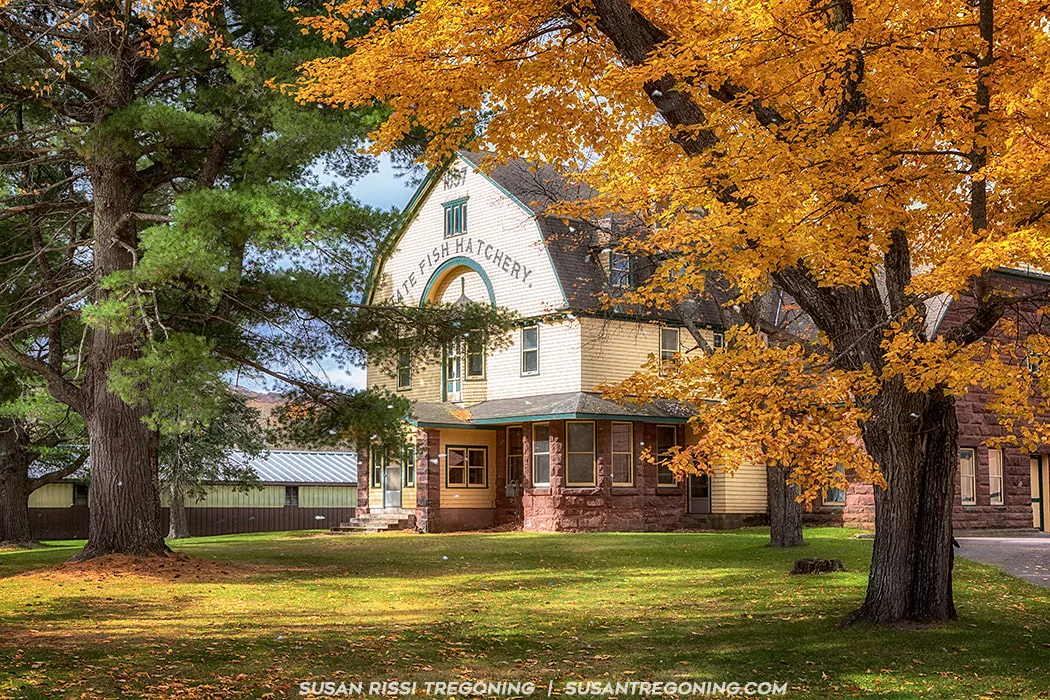
Late fall at the Les Voigt State Fish Hatchery, where the beautiful autumn leaves are still on the trees and snowflakes drift through the air. This impressive 1897 Victorian Shingle‑style building sits at the entrance to the hatchery. It is still used today for supplemental fish‑rearing space, although the majority of operations now take place in the newer building behind it.
Built from local brownstone, this structure played a historically significant role in the fishing industry on Lake Superior. It was listed on the National Register of Historic Places in 1981.
Les Voigt State Fish Hatchery
83875 Hwy 13, Bayfield
The Les Voigt State Fish Hatchery raises lake trout, splake, and brown trout for stocking in the northern Great Lakes and many inland lakes and streams throughout Wisconsin. It is open daily from 8 a.m. to 4 p.m., April through October.
Salmo Lake Walk Trail
83645 State Hwy 13, Bayfield
A 1.5‑mile trail with interpretive signage along the route leading to a sand beach. It sits across the highway from the Les Voigt State Fish Hatchery.
The Fruit Loop
Bayfield is the "Berry Capital of Wisconsin". The rolling hills near Lake Superior offer a unique micro climate which is conductive to growing fruit.
I did not find this map until we were at one of the Orchards. Every location on the Loop has it hanging on their wall. It would have been nice to have this on hand for the drive.

Bayfield Peninsula “Fruit Loop” Map A visual guide to the region’s berry farms, orchards, and wineries/tasting rooms.
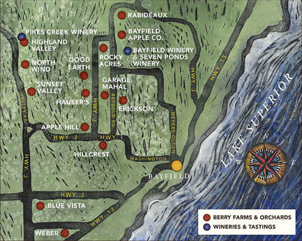
You can print a copy of the Fruit Loop brochure, complete with all addresses and details, from the Bayfield Tourism website.
I didn’t have time to visit every location on the loop, but the Bayfield Winery stood out with a particularly interesting presentation of their wines. We also stopped at Copper Crow, a vodka distillery that is not part of the loop.
I visited a few of the orchards, choosing those with especially interesting barns. On a recommendation from a local, we also stopped at Erickson’s for cider donuts and hot cider, both of which were excellent. We picked up a couple of their apple cookies, which were truly outstanding—rich and more like apple cake with a cream cheese icing.
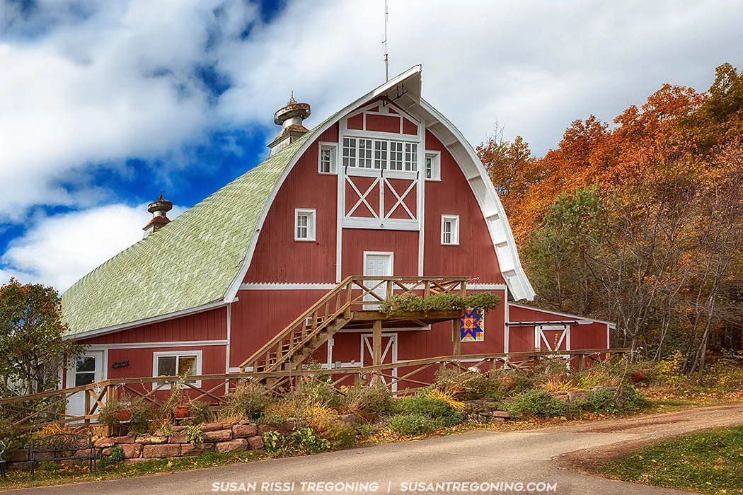
This cute red barn was purchased from the Sears Roebuck catalog for $896 in the early 1920’s. It was shipped by train to Bayfield, Wisconsin where it was then hauled 600 feet up the hill from Lake Superior by horse drawn wagon. It housed pure bred Golden Gurnsey cows until the 1950s. It is still owned by the same family and is now the store front for Hauser’s Superior View Farm.
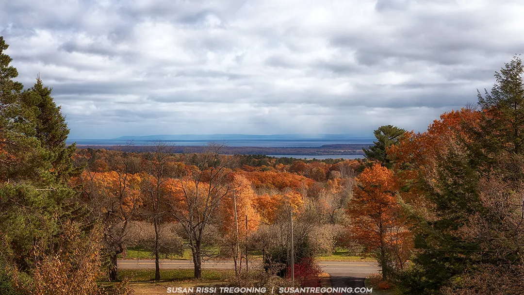
The beautiful autumn view from Hauser’s Superior View Farm, photographed from the loft window at the top of the barn. Brilliant fall colors sweep across the hillside, with Lake Superior visible in the distance.
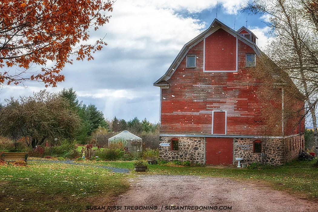
Fall may be apple season, but Mother Nature was already hinting at winter with snow flurries sweeping across the Bayfield Peninsula when I found this fabulous old red barn. It serves as the fruit store at Blue Vista Farm, a charming stop along the loop.
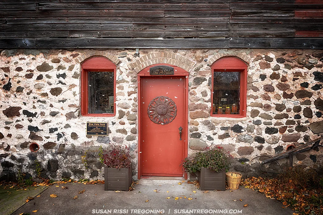
A rustic stone doorway with its bright red accents welcomes visitors to Blue Vista Farm’s fruit store.
City of Bayfield Information Kiosk: East Dock Park
As you ascend the long hill into the City of Bayfield, many of the remaining Apostle Islands come into view. With a population of just 487, Bayfield is the smallest city in Wisconsin.
Known as the Gateway to the Apostle Islands, Bayfield’s marina provides ferry service to Madeline Island and is also the departure point for Apostle Islands tour boats when they are running.
Brownstone Trail
This nearly 3‑mile trail follows an abandoned Chicago and North Western Railway corridor from historic downtown Bayfield—near the intersection of ManyPenny Avenue and S. 3rd Street—to the Port Superior Village Marina south of town. The route hugs the shoreline of Lake Superior, tracing the brownstone cliffs that give the trail its name.
Gil Larson Nature Trail
Part of the Big Ravine Forest Preserve, this trail begins on Sweeny Avenue, across from the School District of Bayfield at 300 N 4th Street. The trailhead appears on the right. The 0.75‑mile hike descends into the deep ravine that cuts through the center of the city. It begins beside a historic apple shed, passes under an old iron bridge, and ends at a small waterfall.
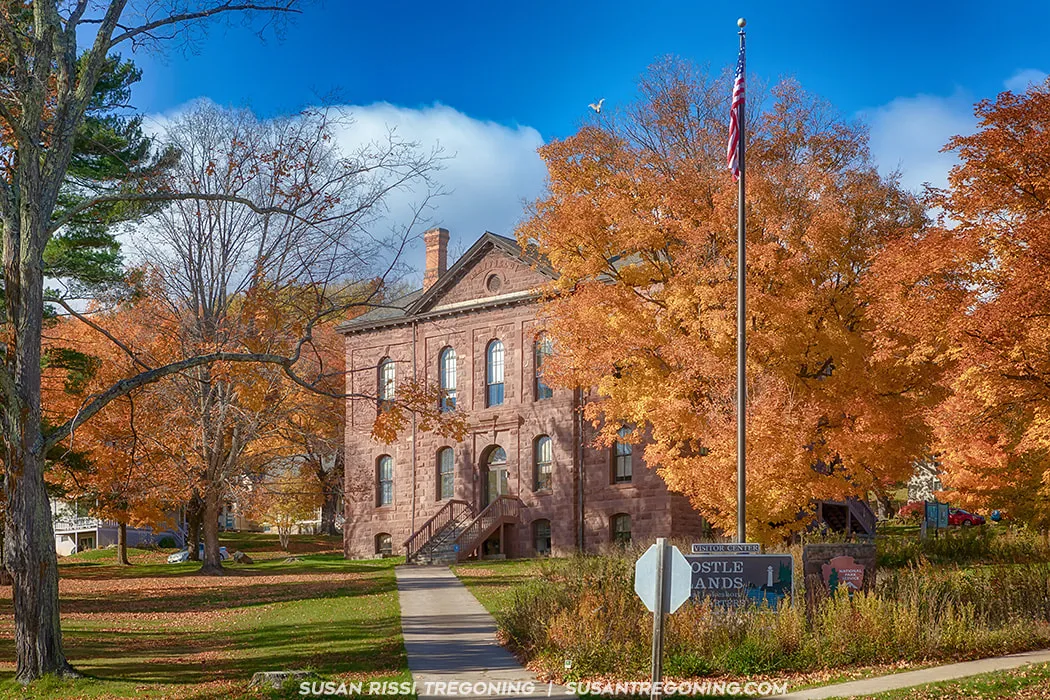
The Old Bayfield County Courthouse was built in 1884 of local brownstone, blending elements of Neoclassical and Romanesque Revival architecture. It served as the county courthouse until 1892, when the county seat moved to Washburn. Over the years, the building has had many lives, functioning as a school, a German POW camp, a community center, and a warehouse. Today, it serves as the Visitor Center for the Apostle Islands National Lakeshore.
The Bayfield Historic District spans 60 blocks, with many of the city’s buildings dating to the late 1800s and listed on the National Register of Historic Places. The district is a mix of quaint cottages, magnificent Victorian homes, and remarkably well‑preserved historic architecture. For an in‑depth architectural walking tour, you can download a free 49‑page booklet from the city.
I only had time for the architectural highlights:
Old Bayfield County Courthouse
Apostle Islands National Lakeshore Visitor Center - 415 Washington Street
Christ Episcopal Church
121–125 North 3rd Street
Booth Cooperage
1 East Washington Street
Frank Boutin Jr. House
Rittenhouse Inn - 7 Rice Street
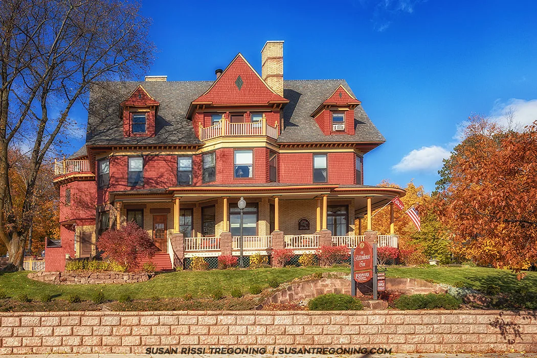
The Frank Boutin Jr. House was built in 1908. It is Queen Anne with an exterior of sandstone, brick and clapboard. Boutin’s father was an early lumberman and fisherman in Bayfield. The home is now a bed and breakfast better known at the Rittenhouse Inn.
Leaving Bayfield, the Byway enters the Red Cliff Band of Lake Superior Chippewa Reservation. The Red Cliff Band is one of 154 Bands of Anishinaabeg who live around the Lake Superior region in both the United States and Canada. The Tribe’s lands include approximately 60 square miles of watershed and shoreline, with 46 miles of streams and rivers and 22 miles of Lake Superior shoreline.
\
Red Cliff Information Kiosk: Frog Bay Tribal National Park
There are several murals throughout the Red Cliff Reservation that highlight the traditional Chippewa way of life, adding vibrant cultural storytelling to the community landscape.
Legendary Waters Resort & Casino
37600 Onigamiing Drive
Inside the casino, you’ll find displays on the history and culture of the Anishinaabe people, offering an informative look at the traditions and heritage of the Red Cliff Band.
Copper Crow Distillery
37295 State Highway 13, Bayfield
A local vodka distillery, Copper Crow was a fun Saturday‑evening stop before dinner.
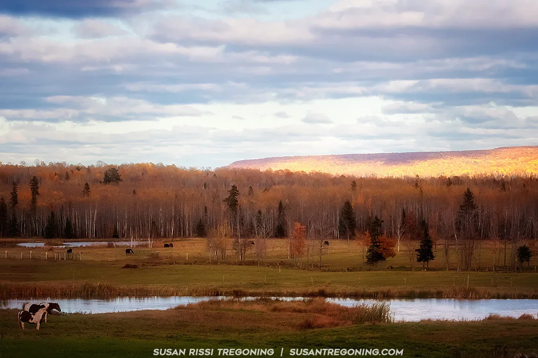
A late autumn pastoral landscape shot during the golden hour with horses in the foreground and cattle grazing the fields in the distance. I captured this image on the Red Cliff Reservation on our drive out to the Frog Bay Tribal National Park.
From Legendary Waters Resort & Casino, follow Blueberry Road for 3 miles. Turn right onto Frog Bay Road and continue until the road ends. The access road to the trail is marked with a Frog Bay sign. A small parking lot and comfort station are located at the trailhead.
There are three different trails leading down to Lake Superior:
Easy Route — 0.4 miles
A straightforward walk down the old beach access road. The trail begins on the right side of the parking lot. This is the quickest and simplest way to reach the lake.
Beach Trail — adds ~0.25 miles
Accessed from the Easy Route, this trail winds through the lower portion of the forest. Walkways have been added in a few spots, but most of the path is fairly level with exposed tree roots. It’s a lovely, quiet walk through the woods before reaching the beach.
Ravine Trail — 1 mile
A more challenging hike. Start by crossing the ravine bridge directly off the parking lot. The trail climbs up and over a ravine and continues through a beautiful boreal forest. It connects with the Beach Trail and takes about 30 minutes one way.
Crossing the bridge on the Ravine Trail at Frog Bay Tribal National Park, surrounded by peak autumn color.
We originally planned to hike the Ravine Trail, but the fallen leaves were so thick that we had trouble finding and staying on the path. With no one else in the park and the trail becoming increasingly hard to follow, I didn’t want to risk getting lost. We eventually turned around and took the easier direct route down to the lake instead.
This park is an old‑growth, primordial boreal forest with pristine Lake Superior shoreline and sweeping views of the Apostle Islands. The land was only recently reacquired by the Red Cliff Reservation through two separate transactions, and—remarkably—it has never been logged. While only two miles of hiking trails are open to the public, the experience is unforgettable and absolutely worth a visit.
During my travel research, I came across a Twin Cities Pioneer Press article that explained how the previous landowner came to hold the property and their deep desire to see it protected. I found the story so heartwarming and compelling that it made me even more determined to visit. If you’re interested, you can read that article HERE.
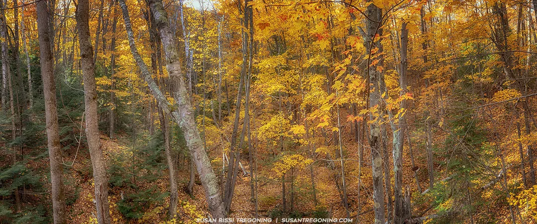
A panoramic view of the fall colors and boreal forest in the ravine as seen from the Ravine Trail bridge at Frog Bay Tribal National Park. The colors in the upper elevation of the Ravine Trail were quite spectacular.
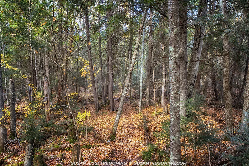
Hiking the Beach Trail through the lower elevation of the boreal forest at Frog Bay Tribal National Park, you immediately notice how the trees closer to water level have already shed most of their autumn color. In the center of this scene stands a small grove of Northern White Cedar, identifiable by their darker, smoother, more vertical bark. These cedars thrive throughout the Great Lakes region and hold deep cultural significance for the Anishinaabe people, who call them Nookomis Giizhik, meaning “my grandmother’s cedar.” They appear in many sacred stories and are one of the important plants represented on the Ojibwe Medicine Wheel.
When we reached the end of the Beach Trail, the Lake Superior water level was so high that the waves were lapping at the top step leading down to the shoreline. With the lake pushed that far inland, I couldn’t get far enough out of the forest to see the beautiful view of the Apostle Islands that’s normally visible from this spot.
After backtracking along the Beach Trail, we debated hiking to the end of the Easy Trail
Completing our hike at Frog Bay Tribal National Park, we followed the Easy Trail back from the beach as the late‑afternoon sun dropped rapidly toward the horizon. The light was blinding at times, but it made the autumn colors glow, turning every stretch of the trail into a warm, golden tunnel of leaves.
Driving primarily westward along the north side of the Bayfield Peninsula, the landscape opens into broad vistas of the south shore of Lake Superior, with the higher hills of northeast Minnesota clearly visible in the distance. Much of this stretch of the Byway lies within the Apostle Islands National Lakeshore and the Gaylord Nelson Wilderness Area, giving the drive an expansive, protected‑land feel.
Following County Highway K leads to Little Sand Bay, where the Town of Russell operates a campground. The Apostle Islands National Lakeshore maintains visitor information here, and the site includes a historic fishery that is open seasonally and offers guided tours.
Russell Information Kiosk: Little Sand Bay Campground
Little Sand Bay Recreation Area
32665 Little Sand Bay Road
It serves as one of the most popular kayak access points to the Apostle Islands, offering direct entry to the open waters between the mainland and Sand and York Islands. The area includes a campground, beach, boat launch, and harbor facilities maintained by the Town of Russell, making it a well‑used hub for paddlers and boaters.
Just a few steps away Hokenson Fishing Dock, built on crib piers in 1927 by the three Hokenson brothers, who operated an independent commercial fishing and packing business out of Sand Island from the 1920s through the 1950s. Their dock and associated fishery structures—now preserved within the Apostle Islands National Lakeshore—tell the story of small‑scale, family‑run fishing operations that once thrived along Lake Superior’s South Shore.
Meyers Beach
This stretch of shoreline marks the location of the mainland sea caves of the Apostle Islands National Lakeshore, one of the most dramatic geological features on Lake Superior’s South Shore.
Meyers Beach sits just past Red Cliff and about 4 miles before Cornucopia, with Meyers Beach Road intersecting the Byway for easy access. In summer, this is considered the best kayak launch site for exploring the mainland sea caves, with paddlers heading out along the towering sandstone cliffs.
In winter—when conditions allow—these same formations transform into the world‑famous ice caves, a frozen wonderland of icicles, blue chambers, and sculpted ice curtains. When Lake Superior freezes solid enough, it becomes possible to hike across the lake to reach them, though conditions can change rapidly and must be checked with the National Park Service.
A hiking trailhead sits adjacent to the parking lot, offering access to the Lakeshore Trail, which runs along the cliffs above the sea caves. The first 0.7 miles are on a boardwalk, after which the trail becomes rugged with stream crossings, steep slopes, and narrow sections along the cliff tops. It’s approximately 2 miles to the first sea cave overlook, and the full trail extends about 4.5 miles.
The sandstone cliffs at Meyers Beach glow with peak fall color above the calm waters of Lake Superior. This stretch of shoreline marks the start of the mainland sea caves of the Apostle Islands National Lakeshore.
Just past Meyers Beach, the view opens wide and the distant hills of northeast Minnesota rise along the far horizon. From here, the Byway makes a steep descent into Cornucopia, a small harbor town tucked into a protected curve of the shoreline. The harbor provides safe shelter for both commercial fishing vessels and pleasure craft, making it one of the most active and picturesque working waterfronts on the Bayfield Peninsula.
Cornucopia AKA Bell Information Kiosk: Bell Marina
Comes Aboat is one of the charming natural‑wood buildings at the Bell Marina, its warm timber siding fitting perfectly with the working‑harbor atmosphere. In the background, the Jackie II fishing boat rests at its slip, adding a touch of authentic South Shore character to the scene.
Siskiwit Bay is a naturally protected, shallow curve of shoreline where the water stays calm even on windy days. Just off the beach, an artesian well flows with clear, cold, safe drinking water year‑round—a small local treasure. Scattered along the shore are several historic wooden boats in various stages of decay, a quiet reminder of Cornucopia’s commercial fishing past.
Cornucopia Green Shed Museum
22670 Siskiwit Bay Pkwy, Cornucopia, WI
Located right next to the beach, this small museum preserves the maritime history of the South Shore. It’s closed during the off‑season, but even from the outside it adds character to the harbor.
Ehlers General Store
88545 Superior Avenue
Operating for more than 100 years, Ehlers is a true old‑fashioned general store—one of those rare places where you can literally buy “everything, including the kitchen sink.” It’s a quick, worthwhile stop if you’ve never experienced a historic community store. (Closed November–May.)
Siskiwit Falls
88605 Siskiwit Falls Rd
To reach the falls, follow Highway 13 into Cornucopia, turn onto County Road C, then take a left on Siskiwit Falls Road. A small bridge appears shortly after the turn—this is your access point.
The waterfall system stretches both upstream and downstream of the bridge.
- Upstream: Portions flow through private property, so be mindful of boundaries.
- Downstream: The best drop is about ¼ mile from the bridge.
- Overall: A series of slides and drops ranging from 2 to 10 feet, with the largest being a smooth 10‑foot slide.
This is a great stop for photographers who enjoy layered cascades and textured bedrock.
Lost Creek Falls
22490 Trail Dr
A 1.5‑mile hike (one way) leads to this small but charming waterfall tucked into the forest. The trail is well‑maintained, and the falls are especially photogenic after rainfall or during spring melt.
Herbster AKA Clover
Info Kiosk: Intersection of Hwy. 13 & Bark Point Road
Historic Log Gymnasium
86870 Lenawee Road, Herbster
Built by the Works Progress Administration in the 1930s.
Bark Bay Slough State Natural Area
Bark Bay Point Road
Leaving Herbster
Leaving Herbster, the byway climbs sharply into higher ground, crossing a series of deep, tree‑lined ravines that cut down toward Lake Superior. The forest closes in on both sides, and through the breaks in the canopy you catch glimpses of the lake far below, its shoreline dropping away in steep, dramatic folds.
Port Wing Information Kiosk: Highway 13 near Johnson's Store, this kiosk provides local information and is a good quick stop for orientation.
Port Wing is an often‑overlooked little fishing village with deep roots in Lake Superior’s maritime history. Two commercial fishing boats still work out of the Port Wing Harbor, and the community retains much of its traditional connection to the lake. It is also the first harbor of refuge east of Duluth/Superior, making it an important stop for boaters navigating the South Shore. Nearly two miles of sandy beaches stretch along the shoreline here, offering peaceful, uncrowded access to Lake Superior.
Quarry Point Beach & Boreal Forest
From Highway 13, turn north on Quarry Point Road and follow it to the small parking area near the entrance path.
Recently named one of the South Shore’s best beaches by Lake Superior Magazine readers, Quarry Beach runs along a beautiful stretch of boreal forest. It’s a quiet, scenic place to walk, beachcomb, or simply enjoy the sound of Superior’s waves.
Big Pete Boreal State Natural Area
From Highway 13, turn right on Lakeview Road, then right on Big Pete Road.
This natural area protects a section of old‑growth boreal forest and a serene Lake Superior shoreline. It’s a peaceful stop for those who appreciate quiet woods, mossy understory, and the unique ecology of the northern forest.
Twin Falls
Twin Falls sits directly off Highway 13 in a small park just west of Port Wing. The signage is easy to miss when heading west—once you realize you’ve left town, turn around and you’ll see the sign on your right just after the Port Wing city limits sign.
Facing the gorge from the parking lot, you have two options:
Left Path:
A short walk leads to a viewing platform directly above the upper falls. The view of the falls is limited from here, but the gorge itself is impressive. Adventurous visitors sometimes cross the stream (expect wet feet) to reach stairs on the opposite side for a better vantage point.
Right Path:
This route takes you easily down to Larson Creek. From here, you can walk upstream—again, expect wet feet—to reach the lower falls, a beautiful 12‑foot plunge tucked into the gorge.
Twin Falls is compact but rewarding, especially for photographers who enjoy intimate waterfall settings.
Reefer Creek Overlook
About five miles east of Port Wing, the byway crosses Reefer Creek and reaches a small scenic pullout with some of the broadest Lake Superior views on the entire route. On a clear day you can see nearly 20 miles across the lake to the Minnesota shoreline—Knife River, Two Harbors, and even Silver Bay shimmering in the distance. From this overlook onward, the byway slips into dense pine forest, the road narrowing between tall, shadowed stands that signal your transition into the wilder, more remote stretch of the South Shore.
Orienta: Information Kiosk: Located at a scenic pull‑out on Highway 13, this small kiosk offers a quick orientation stop and a chance to take in the surrounding forest and rolling terrain.
Orienta Falls
From Port Wing, follow Highway 13 west for about five miles, then turn south on Orienta Falls Road. Continue 1.25 miles to Falls Spur Road. The falls sit at the former site of the Lake Superior Power Company Dam, where the Iron River cuts through a rugged, wooded corridor.
A short walk—just a couple hundred yards—brings you to the river. The setting feels remote and historic, with the river flowing over bedrock shaped by both natural forces and the remnants of early industry.
Iron River Brownstone Quarry
Just below Orienta Falls lies the Iron River Brownstone Quarry, which began operation in 1893 and supplied stone for buildings throughout the region. Though long abandoned, the site still hints at the scale of the operation, with exposed layers of warm brownstone and the quiet echo of Wisconsin’s quarrying past.
Brule River Boreal Forest State Natural Area
Signs along Highway 13 point the way to the road leading to the mouth of the Brule River, one of the most storied trout streams in the Midwest. Here, the river meets Lake Superior at a broad sand beach, a peaceful place where anglers, bird‑watchers, and photographers linger.
The surrounding boreal forest supports a rich mix of wildlife—deer, eagles, and the occasional fox, wolf, or black bear. It’s a landscape that feels both wild and deeply rooted in the natural heritage of the South Shore.
Cloverland Information Kiosk: Town Hall
The Old Schoolhouse in Cloverland
Right along Highway 13, the Old Schoolhouse in Cloverland stands as a quiet reminder of early rural education on the South Shore. This abandoned two‑room schoolhouse has an unusual origin story: in 1916, the Harvey School and King School were physically joined together—literally moved and connected using a horse and sleigh.
When the school closed in 1948, the building found new life as the Cloverland Community Club, becoming a social hub for local residents. Over time, as the population aged and the community grew smaller, the building was eventually abandoned. Today it sits weathered but still dignified, a piece of living history visible from the byway.
The old Cloverland schoolhouse, created in 1916 by joining two rural schools, now standing empty along the Lake Superior Scenic Byway.
End of the Wisconsin Lake Superior Scenic Byway
The Wisconsin Lake Superior Scenic Byway officially ends two miles past the historic town of Cloverland, at the junction of State Highway 13 and County Road H. It’s a quiet, unassuming finish to a route defined by sweeping lake views, forested stretches, and the layered history of the South Shore.
Not every image makes it into my blog. If you enjoyed the photos in this article, please check out my Wisconsin Collection for more pictures from this amazing state, or visit my Image Gallery with over 4000 images of locations around the United States.

Bring the warmth and serenity of autumn indoors with this beautifully framed waterfall landscape. Gentle, flowing water glides over time-worn stone, surrounded by a forest glowing in rich amber and earthy tones—capturing a peaceful moment you can return to every day. The thoughtfully chosen double mat and natural wood frame enhance the depth and color of the scene, making it a perfect focal point above a sofa or in any cozy living space. It’s more than wall art—it’s a quiet escape, a breath of fresh forest air, and a touch of timeless nature for your home.
Fine Art Prints are available for order as print only, framed art, canvas art, metal art, acrylic art, and wood art prints in various sizes. Home Decor and Gift Ideas include shower curtains, throw pillows, towels, totes, phone cases, t-shirts, puzzles, blankets, and more. Worldwide Shipping with a 30-day money-back guarantee.
More of the USA
- A Travelers Musings (1)
- Alabama (1)
- Hawaii (3)
- Illinois (6)
- Indiana (3)
- Iowa (3)
- Louisiana (1)
- Maryland (1)
- Michigan (2)
- Minnesota (4)
- Mississippi (6)
- Missouri (2)
- Montana (1)
- Nebraska (5)
- New Mexico (1)
- North Carolina (1)
- Pennsylvania (2)
- Route 66 (5)
- South Dakota (1)
- Tennessee (1)
- Texas (1)
- Virginia (2)
- Washington DC (1)
- West Virginia (3)
- Wildlife (6)
- Wisconsin (2)
- Wyoming (4)
