Escape to the Blue Ridge Parkway
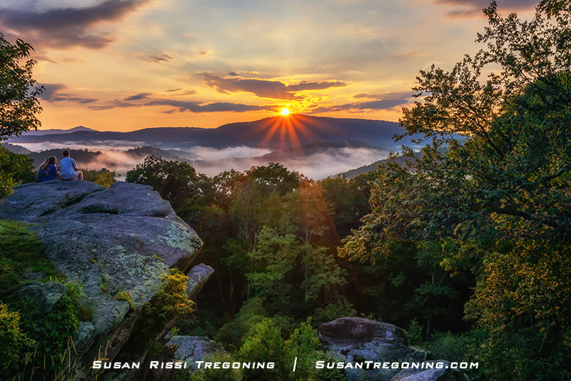
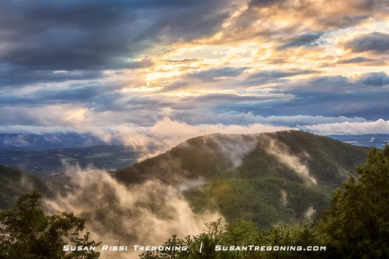
Sunset from Raven Rocks Overlook (MP 289.5) in the North Carolina High Country, with sweeping views toward Boone and Blowing Rock. The overlook’s rocky ledges and northwest‑facing vista make it one of the Parkway’s most dramatic spots for evening light.
At 468 miles long, the Blue Ridge Parkway is one of America’s most celebrated scenic drives—designated both a National Parkway and an All‑American Road, the highest honor in the National Scenic Byway system. Beginning at Shenandoah National Park in Virginia, the Parkway follows the spine of the Blue Ridge Mountains, winding south through North Carolina before ending at the Cherokee entrance of Great Smoky Mountains National Park.
Along its route, the elevation shifts dramatically—from 6,053 feet near Mount Pisgah in North Carolina to just 649 feet along the James River in Virginia. These changes in altitude and landscape create an ever‑shifting tapestry of views: sweeping mountain and valley vistas, quiet pastoral scenes, sparkling waterfalls, and vibrant displays of wildflowers and seasonal foliage.
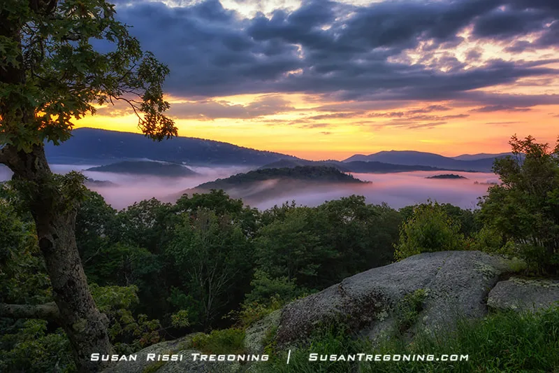
Sunset from Raven Rocks Overlook (MP 289.5) in the North Carolina High Country, where clouds pool between the ridgelines and create the illusion of floating mountain islands. The warm evening light reflects across the tops of the clouds, adding depth and color to the layered Blue Ridge landscape. Both this image and the one above were captured from Raven Rocks Overlook, widely regarded as one of the premier sunset locations along the Blue Ridge Parkway.
I was beyond excited when we received an assignment in Roanoke, Virginia at the end of 2019. The Blue Ridge Parkway had been on my bucket list for years, and Roanoke sits right on it—an absolute dream for a photographer. I dove straight into planning: researching hiking trails, mapping out weekend drives, and counting down the days until spring. And then COVID hit, bringing everything to a sudden, surreal halt.
Elk Mountain Overlook (MP 274.3) sits at an elevation of 3,795 feet and is one of the Blue Ridge Parkway’s most popular stops. From here, you get a sweeping view of the Yadkin Valley, named for an Indigenous village that once stood near the river below. The overlook’s broad, open vista makes it a favorite for photographers and Parkway travelers alike.
During the lockdown, the Blue Ridge Parkway became my escape. When I could not stand to be in the house a moment longer, I would go up to a nearby overlook where I could be entirely by myself and photograph these magnificent views. I couldn't have asked for a better location to spend that time. It was such a blessing!
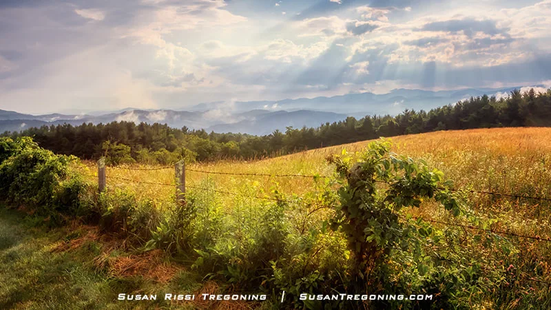
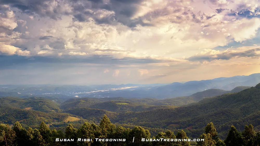
A quiet pastoral stretch along the Blue Ridge Parkway reveals a wide view of rolling green hills and distant mountains, illuminated by dramatic rays of sunlight breaking through the clouds. This scene wasn’t captured at a designated overlook—just one of those unexpected roadside moments where the landscape opens up and the light turns extraordinary.
I mistakenly thought I would be the only one up on the Parkway, but all the locals were sneaking up there too. There was always a "deer in headlights" moment from the people at the overlooks when I would pull in in the early days of lockdown. So many times, they would grab their things and run to their cars even when we had 50 feet of space between us.
As restrictions began to loosen up, the trails became packed. As a result, I didn't complete any of those hikes I'd planned, but I did manage to drive the entire Parkway and visit all the overlooks.
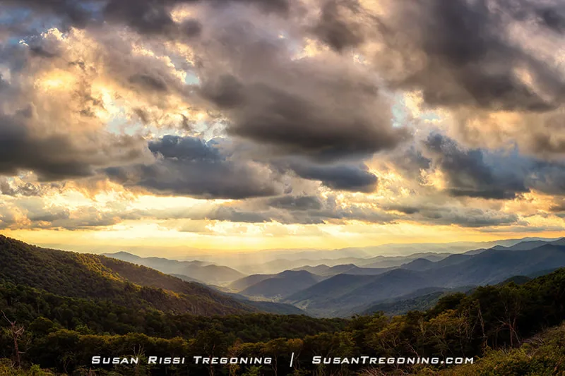
Golden hour settles over the Blue Ridge Mountains as sunbeams break through heavy clouds, casting warm light across the layered ridgelines. This view sits just uphill from the Glassmine Falls Overlook (MP 361.2), with the overlook itself positioned behind the camera.
Virginia kept most of its trails open, while North Carolina gated Parkway access wherever they could. By the time many of the major overlooks and sites finally reopened, I was already off to another assignment. I missed so much of the Parkway during those months that I hesitate to call this a true travel blog post. Instead, I’ve tucked in a few of my favorite Parkway planning links and some basic information at the end. The title really says it all—this is a photographic escape to the Blue Ridge Parkway. Save it for the days when you need a quiet, virtual retreat to the mountains.
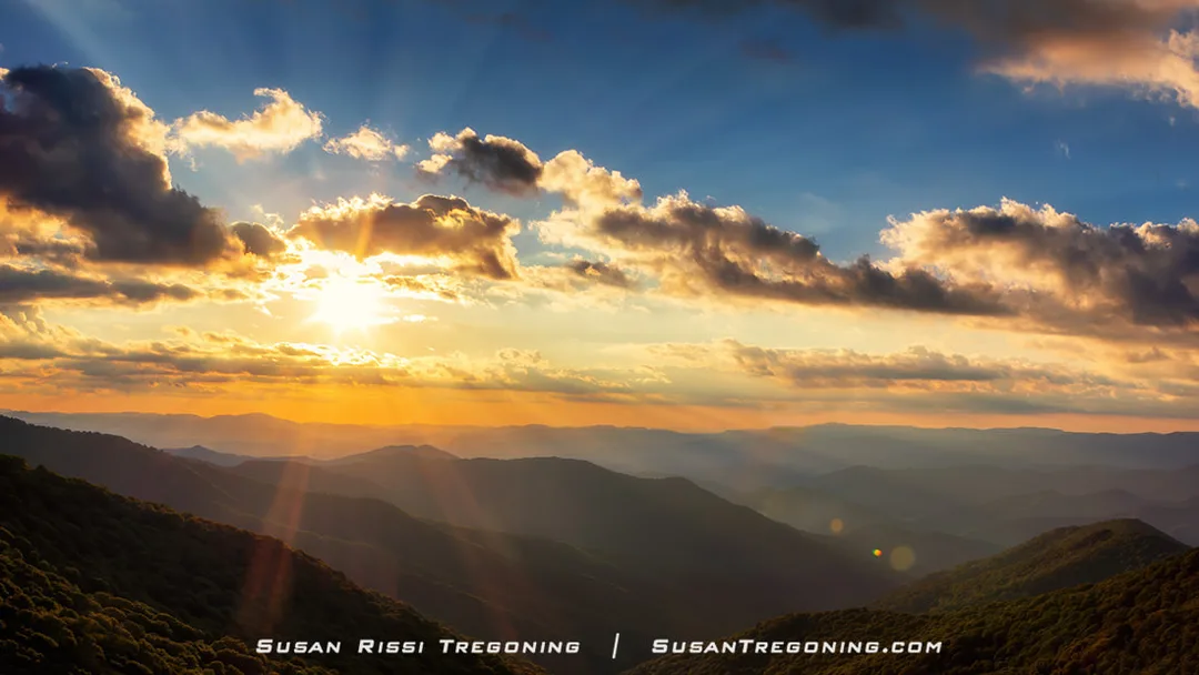
Golden hour at the Craggy Gardens Visitors Center Overlook (MP 364.5) lit the sky with a dramatic halo of sunbeams, a full circle of rays radiating outward over the layered ridgelines.
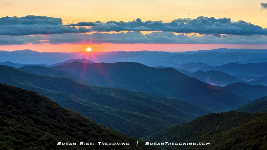
As evening settled in, the mountains glowed with warm color near the Craggy Gardens Visitors Center Overlook (MP 364.5). It’s no surprise Craggy Gardens is considered one of Asheville’s premier sunset locations.
A Little History
U.S. Senator Harry Byrd of Virginia first proposed the idea of a scenic Parkway to President Franklin D. Roosevelt during Roosevelt’s visit to the newly completed Skyline Drive at Shenandoah National Park. Byrd envisioned a continuous route along the Appalachian Mountains that would link Shenandoah to the Great Smoky Mountains.
Roosevelt immediately embraced the concept. The country was deep in the Depression, and the recent opening of Great Smoky Mountains National Park had been a major success. A new mountain Parkway would create much‑needed jobs in one of the nation’s most economically distressed regions, while eventually bringing tourism dollars to communities that desperately needed them.
At the Great Valley Overlook (MP 99.6), the landscape opens to the long corridor once known as the Great Warrior Path. This same route later guided waves of Scotch‑Irish and German settlers as they moved south through the Appalachians in the mid‑1700s.
The original name for the Parkway was the Appalachian Scenic Highway.
Stanley Abbott, the Parkway’s Chief Landscape Architect, shaped its guiding design philosophy. His goal was, in his words, “to fit the Parkway into the mountains as if nature had put it there.”
After two years in the planning stage, construction began on September 11, 1935. At the time, it’s unlikely anyone fully grasped the scale of what lay ahead. Building the Blue Ridge Parkway would become one of the most ambitious landscape‑architecture and road‑construction projects in American history.
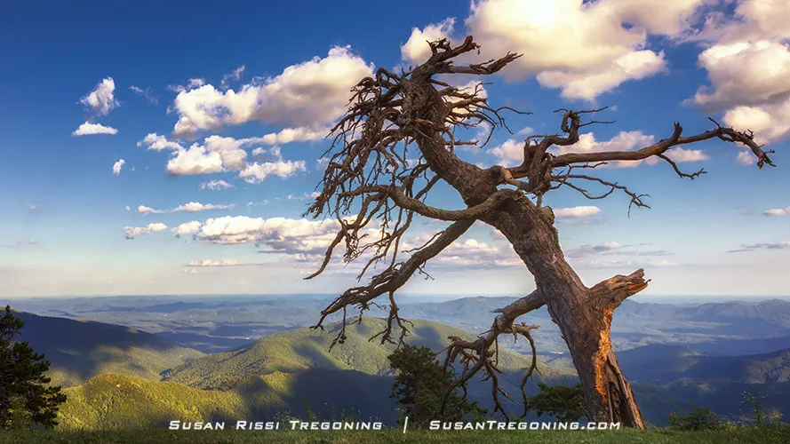
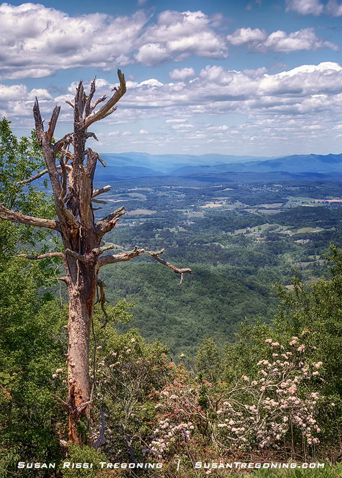
Perched on the edge of the Blue Ridge Mountains at the Laurel Knob Overlook (MP 349.2), this wonderfully crooked tree looked like it was begging someone to grab a branch and straighten it back up.
Private contractors working under federal contracts handled most of the road construction. Skilled Italian and Spanish stonemasons completed the stonework on the bridges and overlooks, while the Civilian Conservation Corps focused on landscaping, trail building, and much of the hands‑on site development that shaped the Parkway’s character.
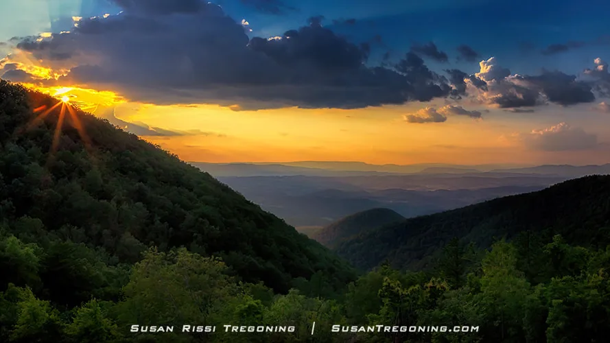
From the Taylors Mountain Overlook (MP 97), the sun’s final glow dropped behind the mountain, leaving the ridges washed in soft evening color.
Progress on the Blue Ridge Parkway was slow. CCC crews had to survey deep into mountains that had never been mapped, and many landowners were reluctant to sell their property. Extreme weather at the highest elevations, rocky terrain along much of the route, and frequent encounters with snakes added to the difficulty. Getting construction equipment to the mountaintops was a challenge in itself, since the existing roads were little more than rutted tracks. All the while, crews worked carefully to preserve the natural beauty of the landscape and avoid unnecessary damage. Construction moved forward in sections as right‑of‑way approvals were finalized and land purchases secured.
Work on the Parkway continued slowly but steadily until the outbreak of World War II. With roughly 170 miles completed, construction came to a halt as federal funding and manpower were redirected to support the war effort.
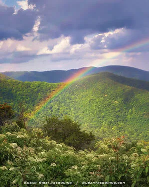
At the Bluff Mountain Overlook (MP 243.4), a sudden rainbow lit up the ridges, adding a burst of color to the clearing sky.
At the Irish Creek Overlook (MP 42.2), the sweeping views vanished into a veil of drifting clouds, leaving only the mist‑covered ridges once settled by Irish and Scottish immigrants in the mid‑1700s.
By 1966, the Parkway was nearly complete. The final missing link was a seven‑mile stretch around Grandfather Mountain in North Carolina. This section would become the Linn Cove Viaduct—an engineering marvel and one of the most successful examples of blending roadway design with the natural landscape anywhere along the Parkway.
At the Cowee Mountain Overlook (MP 430.7), layer after layer of blue ridges disappears into the incoming storm—an unforgettable view from nearly 6,000 feet.
At the Waterrock Knob Visitor Center (MP 451.2), the first rhododendron blossoms signal spring at 5,820 feet. From this high perch, nearly every major Southern Highlands range unfolds in a full circle around you.
Although many sections of the Parkway had been open for decades, it ultimately took fifty‑two years before travelers could drive the entire route continuously from Shenandoah National Park to Great Smoky Mountains National Park. The Blue Ridge Parkway was officially dedicated on September 11, 1987. Today, it stands as the most visited site in the National Park system.
From the Waterrock Knob Visitor Center (MP 451.2), the road curves through evergreens toward a panorama of blue ridges fading into the distance—one of the most expansive views on the Parkway.
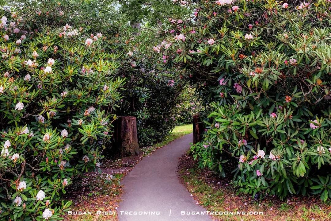
At the Price Lake Overlook (MP 296.7), a blooming rhododendron tunnel ushers hikers onto the lakeside trail—one small piece of the 4,200 acres Julian Price gifted to create the memorial park that bears his name.
The Blue Ridge Parkway is beautiful in every season, but the best times to plan a visit are usually mid‑June or mid‑October.
From June through early July, the rhododendron and mountain laurel bloom is unlike anything else—whole sections of the Parkway become corridors of flowers, and many trails wind directly through rhododendron thickets.
Autumn is a bit more unpredictable because of the Parkway’s dramatic elevation changes. Color above 5,000 feet typically begins in early October and works its way down into the valleys by the end of the month. Peak is usually around mid‑October, but Mother Nature sets the schedule; in 2020, the best color didn’t arrive until late October. The North Carolina section, with its higher elevations, colors up first, followed by the Virginia portion. Expect the foliage to vary significantly from one stretch of the Parkway to the next.
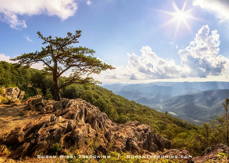
At the Ravens Roost Overlook (MP 10.7), the lone pine clings to the cliff edge as sunlight spills across the ridges below. Ravens, buzzards, and rock climbers frequent this broad rock ledge, perched high above Torrey Ridge and the Shenandoah Valley.
Living History of the Blue Ridge
While the Blue Ridge Parkway is best known for its natural beauty, don't miss out on the Appalachian mountain history sites that can be found along the way.
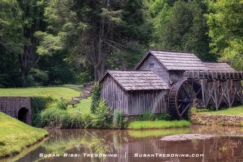
At the Mabry Mill (MP 176.2), the waterwheel turns beside the pond much as it did when Ed Mabry built his blacksmith shop here in 1903. Over time it became a sawmill, then a gristmill, and today it stands as one of the most beloved historic landmarks on the Blue Ridge Parkway.
On Groundhog Mountain, the Puckett Cabin (MP 190) stands as a tribute to Orlean Hawks Puckett—an Appalachian woman who endured unimaginable loss yet went on to deliver over 1,000 babies with unwavering skill and compassion. This humble cabin was her final home.
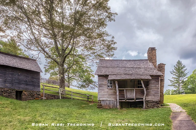
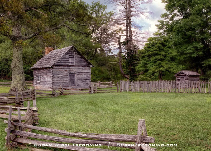
Built in 1880, the Brinegar Cabin (MP 238.5) stands on its fieldstone foundation much as it did when Martin Brinegar raised his family here. The crooked porch post—imperfect, practical, and full of character—feels like a small echo of the mountain life this cabin represents.
Blue Ridge Parkway Travel Basics
The speed limit on the Blue Ridge Parkway is 45 mph, and it drops even lower in steep, curvy sections or areas with heavy pedestrian traffic. Roadside parking is allowed as long as your vehicle is completely off the pavement. Keep an eye out for bicyclists—there are many on the Parkway, and the curves can make them hard to see.
Plan for a slow, leisurely drive with frequent stops. In some stretches, multiple overlooks appear within a single mile, so the miles add up slowly. If you want to explore a few trails along the way, allow at least four days to drive the Parkway end‑to‑end.
It’s easy to experience “beauty overload” on this route. A midday off‑Parkway break can help reset your senses, and then you can return to the mountains for sunset. The early morning and late‑afternoon light offers the most beautiful views of the ridges.
Because temperatures vary dramatically with elevation, dress in layers and be prepared for quick changes in weather.
Cell service is unreliable in many areas, so plan ahead and don’t rely on your phone for navigation or information.

From the Lane Pinnacle Overlook (MP 372.1), the early‑evening light drifts across the ridges, revealing a broad sweep of mountains from nearly 3,900 feet above the valleys below.
Useful Planning Links
Always check the National Park Services Blue Ridge Parkway website for Parkway closures before traveling. The Blue Ridge Parkway Map is easily found along the Parkway but, here is a link to it for planning purposes.
I found Virtual Blue Ridge to be one of my favorite websites for Blue Ridge Parkway planning.
The Blue Ridge Parkway Travel Planner was the one reference guide I wanted with me on every trip down the Parkway. You can access the online version here or request one by mail. I found it most helpful in finding food, gas and for those off-Parkway excursions.
Not every image makes it into my blog. If you enjoyed the photos in this article, please check out my Virginia and North Carolina Collections for more pictures from this amazing state, or visit my Image Gallery with over 4000 images of locations around the United States.

Bring the serenity of the Blue Ridge Mountains into your home with this stunning sunset from Raven Rocks Overlook (MP 289.5) near Boone and Blowing Rock, North Carolina. Framed in rich wood with double mats that echo the golden tones of the evening light, this artwork captures the quiet grandeur of the Appalachian landscape. Perfect for collectors and nature lovers, it adds warmth, depth, and timeless beauty to any space.
Fine Art Prints are available for order as print only, framed art, canvas art, metal art, acrylic art, and wood art prints in various sizes. Home Decor and Gift Ideas include shower curtains, throw pillows, towels, totes, phone cases, t-shirts, puzzles, blankets, and more. Worldwide Shipping with a 30-day money-back guarantee.
More of the USA
- A Travelers Musings (1)
- Alabama (1)
- Hawaii (3)
- Illinois (6)
- Indiana (3)
- Iowa (3)
- Louisiana (1)
- Maryland (1)
- Michigan (2)
- Minnesota (4)
- Mississippi (6)
- Missouri (2)
- Montana (1)
- Nebraska (5)
- New Mexico (1)
- North Carolina (1)
- Pennsylvania (2)
- Route 66 (5)
- South Dakota (1)
- Tennessee (1)
- Texas (1)
- Virginia (2)
- Washington DC (1)
- West Virginia (3)
- Wildlife (6)
- Wisconsin (2)
- Wyoming (4)
