A Guide to Parke County, Indiana: The Covered Bridge Capital of America


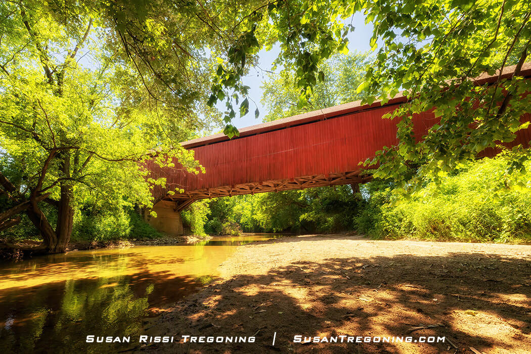
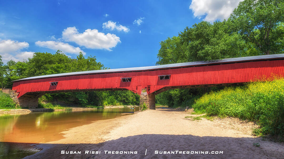
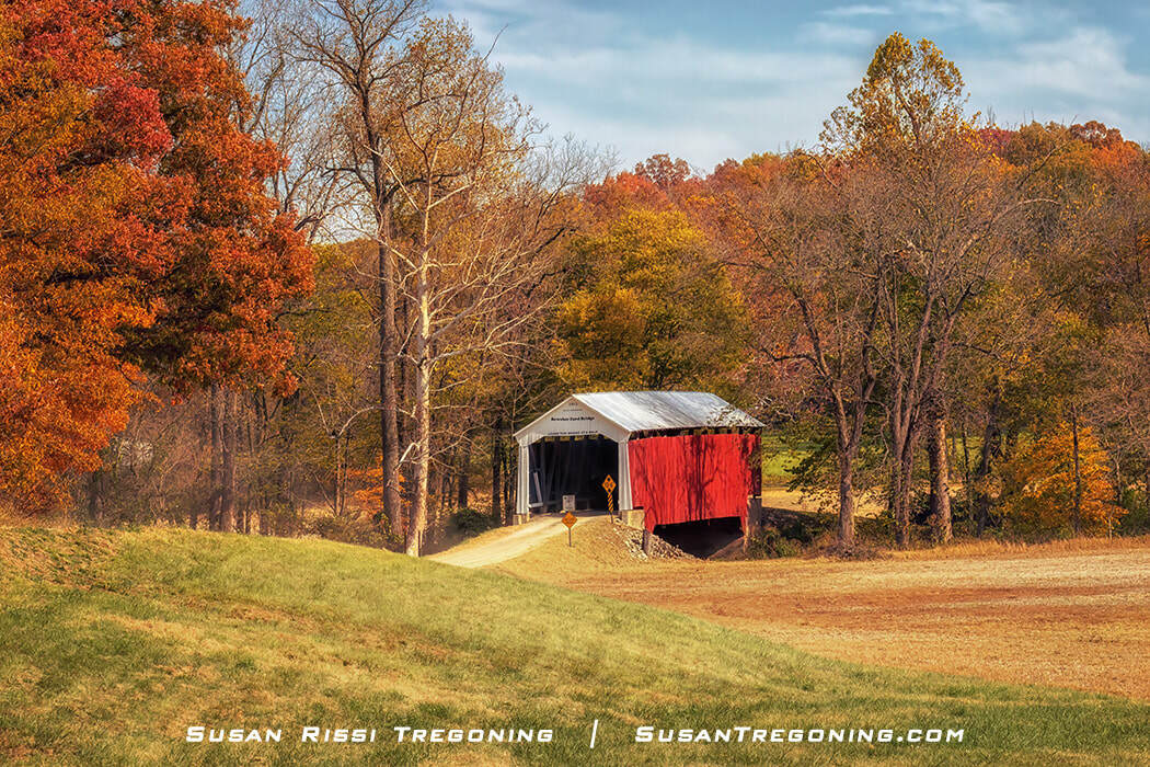
The Narrows Covered Bridge stands over Sugar Creek in full autumn color, a classic Parke County landmark framed by vibrant foliage and quiet water.
In the 1800s, covered bridges were built on narrow dirt roads as safe passages across scenic winding streams. They remind us of a simpler time when horse and buggy were the mode of transportation between small rural towns. Today, these charming iconic landmarks are in picturesque settings virtually untouched by the years. They are both appealing and a reminder of their significance as part of our heritage.
Sadly, only a fraction of these wooden bridges remain since maintaining these old beauties takes a concentrated effort. We once had over 10,000 covered bridges scattered throughout the United States, but now only around 750 have survived.
Parke County, Indiana, is one such gem of a location. It is the self-proclaimed "Covered Bridge Capital of America," with 31 covered bridges. It is #1 for having more covered bridges than any other county in the United States.
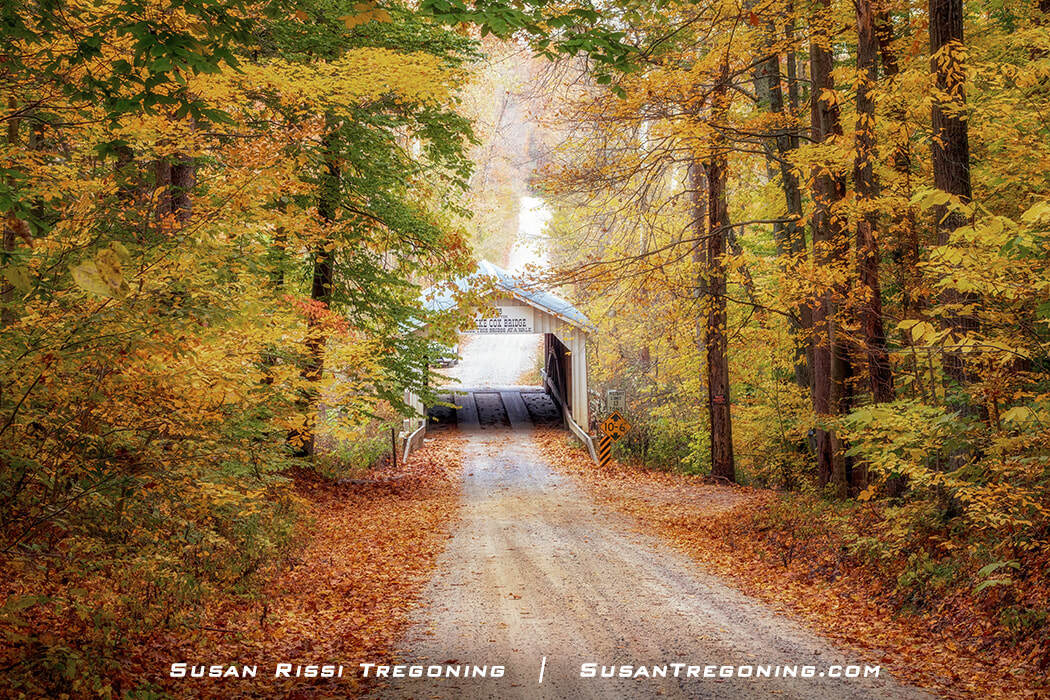
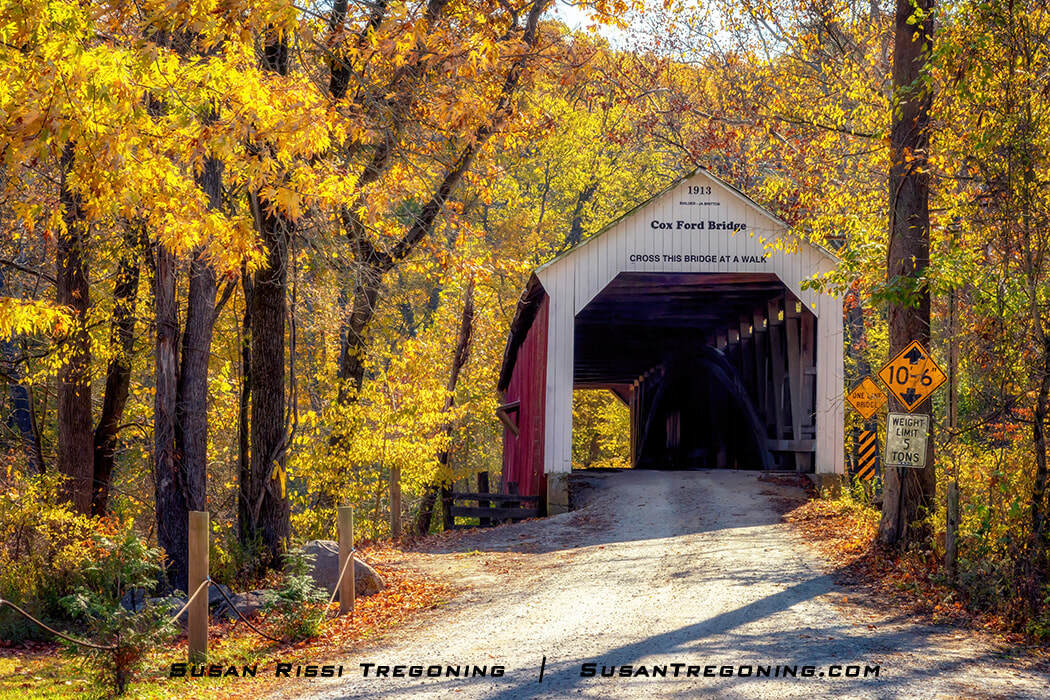
Brilliant autumn foliage frames the Zacke Cox Covered Bridge, a classic Parke County landmark and stop #20 on the county’s covered bridge map.
When you compare Parke County's 31 covered bridges to the top six states with the highest number of covered bridges: Pennsylvania (211), Ohio (144), Vermont (104), Indiana (98), New Hampshire (60), and Oregon (49), that's a lot of covered bridges in one centralized location!
Parke County once had 58 known covered bridges, of which only 31 remain. Twenty-one of these bridges can still be driven through. While the other ten have retired and are only open to pedestrian traffic.
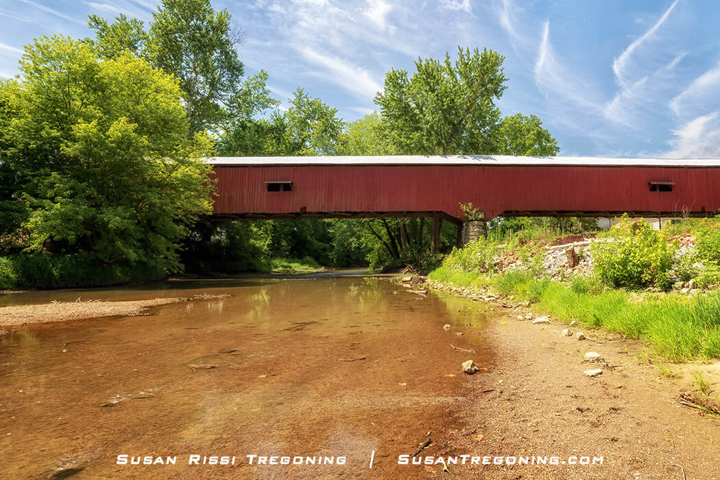
All the Parke County Covered Bridges are listed on the National Register of Historic Places as the “Parke County Covered Bridge Historic District,” except for Bridgeton Bridge, rebuilt in 2006 after the historic bridge was lost to arson.
What is a covered bridge?
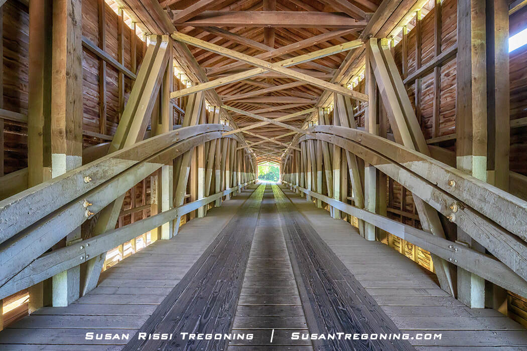
Not every bridge with a roof is an actual covered bridge. A covered bridge must have a wooden truss framework to distribute the weight of the load-bearing deck. The truss’s design complexity determines how long the bridge can span and how complex it is to build. Then, the truss system has to be covered to make it an actual covered bridge.
Why were bridges covered?
When bridges were constructed of wood, the cover not only strengthened the structure but also protected the wood from the elements, which would cause it to weather faster and rot. An uncovered wooden bridge might only last 15 to 20 years, but adding the cover significantly increased the bridge’s lifespan. These bridges are over 100 years old!
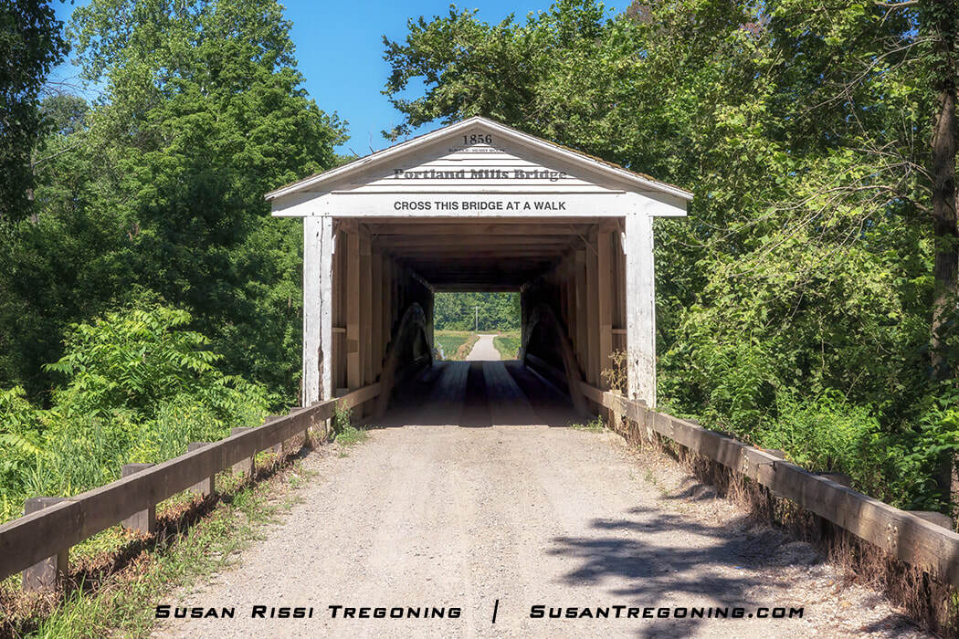
Why are the Parke County covered bridges inscribed with “Cross This Bridge At A Walk"?
Today, this is more historical than anything else, although many Amish families who live in the Parke County area still travel by horse and buggy, so it’s a good reminder for them.
"Cross this bridge at a walk" reminds them to slow their horses to help minimize the stress and structural damage caused by rhythmic pounding. Soldiers also broke cadence when crossing wooden bridges for the same reason. That rhythmic pounding does far more harm than the weight of a car.
What is the Ten O'clock Line?
Driving around Parke County, you’ll see historical markers identifying the Ten O’Clock Line, a boundary created by the Treaty of Fort Wayne in 1809. The line follows the course of Big Raccoon Creek, and one of the markers stands near Bridgeton, about as close to the treaty line as the town can be. The sign sits on the far side of the bridge.
These markers reference a treaty that transferred millions of acres of Native American land in Indiana and Illinois to the United States—an action that helped ignite Tecumseh’s War.
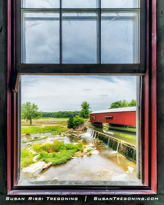
Looking out from the historic Bridgeton Mill toward the Bridgeton Covered Bridge, with the waterfall and stream completing this classic Parke County scene.
Local legend adds a more symbolic layer to the story. According to tradition, Native leaders distrusted the surveyors’ instruments and instead threw a spear at ten o’clock, using the direction of its shadow to define the boundary. Everything south of that shadow—the Ten O’Clock Line—was then opened for settlement.
Parke County's Two Master Bridge Builders
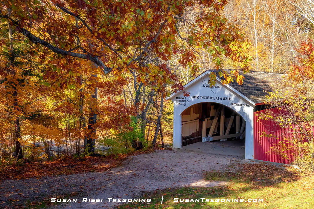
While many different bridge builders built bridges in Parke County, two names are repeatedly seen on the bridges: J.A. Britton and J.J. Daniels.
J. J. Daniels (1826–1916) Joseph John Daniels was born in Marietta, Ohio, the son of a bridge builder. While he had no formal education, his parents highly educated him at home, and he is said to have read both Latin and Greek.
His father, Stephen Daniels, was an agent working under Stephen Long. Long is said to be the first engineer to apply mathematical theory to bridge design, and he spent many years surveying and building the B&O Railroad.
Stephen Daniels built long-truss bridges in southern Ohio in the 1830s and 1840s, many of which were railroad bridges. Joseph helped his father in the 1840s, learning the bridge-building business from him.
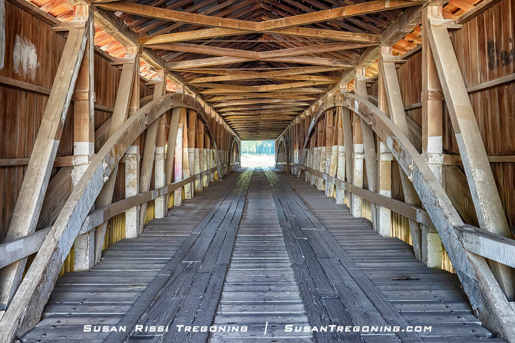
Inside the Mansfield Covered Bridge, J. J. Daniels’ signature burr arches rise in perfect symmetry—an engineering hallmark where the span dictated the graceful height of each curve.
Before leaving Ohio, J.J. Daniels built six long truss bridges in Greene County and Warren County, Ohio, between 1847 and 1852.
In 1853, he moved to Indiana, working as a construction engineer for the Evansville & Crawfordsville Railroad. That first year, he built a 600-foot long, 4-span Burr Arch bridge deemed "The Best in the West."
After eight years with the railroad, Daniels moved to Parke County. His first Parke County covered bridge was Jackson Bridge in 1861. It is considered the most masterful of his 43-year career in covered bridge construction, which is not surprising since it opened the doors for all future covered bridge contracts in Parke County.
While he preferred to build with the Burr Arch Truss, he occasionally used the Howe Truss. His arches were perfectly symmetrical curves, with the span’s length determining the arch’s height.
Daniels liked to experiment with new and innovative ideas. He used metal brace holders or “shoes” to place braces, which required less carpentry work. He also set an iron plate between the masonry abutment and the wooden arch to increase the arch’s life by preventing the wood from absorbing moisture from the stone.
J. J. Daniels built twenty covered bridges in Parke County and nine in other Indiana counties. He may have built as many as 60 bridges in his lifetime, but only 53 can be substantiated. Today, eight of Daniels' covered bridges still stand in Parke County ( 5, 6, 10, 21, 24, 26, 28 & 39), and seven others are scattered throughout the state.
Daniels was 78 years old in 1904 when he built his final bridge, the Neet Covered Bridge. He lived to be 90.
J. A. Britton (1839–1929) might have attended six months of school in his lifetime, but he was naturally studious and widely read.
Joseph Albert Britton's father taught him carpentry, and he was a well-known Parke County carpenter long before he considered going into the bridge-building business.
A Civil War veteran, he enlisted with the local infantry in 1862 and was quickly sent off to Kentucky with little training and no uniforms. In his unit's first skirmish, they were captured and became prisoners of war.
After the war, Britton turned his attention to reading law books and was admitted to the Indiana and Kansas state bars. However, he quickly discovered that the life of a barrister wasn’t for him. By 1870, he had returned to Rockville to resume building houses.
J.A. Britton was already 50 when he started working on bridge-building projects. While no documentation has ever been found that Britton and Daniels were even friends, it is known they competed for many of the same jobs. There is speculation that Britton may have worked for Daniels while learning the business since there are many similarities in their bridge construction, the most prominent being a wood preference, timber sizes, panel construction, and their usage of the Burr Arch Truss.
Britton was awarded his first covered bridge contract for Narrows Covered Bridge in 1882. With a career that lasted thirty-three years, he and his sons are credited with having built around 40 bridges in three counties. Twelve of Britton's Parke County covered bridges (1, 11, 14, 16, 19, 20, 22, 23, 25, 29, 36, & 37) are still standing, and four are in neighboring Putnam County.
Britton was primarily known for building short one-span bridges, with only two double-span bridges attributed to him. All of his bridges were Burr Arch Truss bridges except for two that were King Post Truss. Phillips Bridge is his last standing King Post Truss.
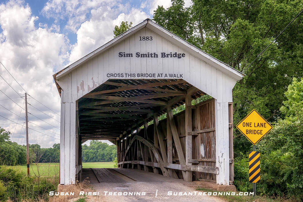
The Sim Smith Bridge showcases J. A. Britton’s early craftsmanship, with a sharply peaked Burr Arch and his signature “Britton Portal,” both hallmarks of his formative bridge‑building years.
Britton's distinctive opening, which bears his name, is known as the "Britton Portal. It has a flat center and sides sharply angled at approximately 130 degrees. He used this portal design on almost all of his bridges, but over the years, as the portals have been repaired, they have not always retained their original openings.
He had 12 children, eight of them boys. His sons, Edgar, Lawrence, Charlton, and Eugene, worked with him on many of his bridges. In 1915, his son Eugene was credited with building the Bowsher Ford Bridge.
Britton lived to be 91.
When should you visit?
Anytime you choose to visit Parke County will be wonderful, but October is by far the most popular month. Since 1957, the county has hosted its countywide Covered Bridge Festival, which begins on the second Friday in October and runs for ten days, right through the height of fall foliage. The festival isn’t confined to one spot; it spreads across the county with vendors and food set up in ten different locations: Rockville, Bellemore, Billie Creek Village, Bridgeton, Bloomingdale, Mansfield, Montezuma, Mecca, Rosedale, and Tangier. Over the decades, it has grown into Indiana’s largest festival and the largest covered bridge festival in the nation. For those ten days, the population of Parke County triples.
I’ve visited Parke County twice. My first trip was a long Fourth of July weekend in summer, and it took the full three days to see all the bridges. Except for the two bridges near Turkey Run State Park (#36 and #37) and the West Union Bridge (#26)—all popular tubing and kayaking spots—I had nearly every bridge to myself. I could walk through them without worrying about traffic and even climb down to the creeks to photograph them when the terrain allowed.
My second visit was during the final weekend of the festival. With only two days, I had to be selective and couldn’t revisit every bridge. I was there for the bridges rather than the festival itself, so I tried to avoid the towns whenever possible since that’s where the crowds and traffic were concentrated.
As expected, there were more people at the bridges than during my summer trip, which made it harder to stand in the road for photos or walk through the spans uninterrupted. But even then, the crowds were nowhere near as heavy as I anticipated. A mid‑week visit during the festival would probably strike the perfect balance—lighter traffic, fewer crowds, and peak fall color. When I was there, some areas were already just past their peak.
The fall foliage on the drives out to the bridges was spectacular. It may have even surpassed the autumn I spent in Vermont—and considering that Vermont in fall is a bucket‑list experience for many people, that’s saying something. My husband and I found ourselves commenting on that repeatedly as we drove the Parke County back roads.
Where should you stay?
Parke County lodging fills almost a year ahead of the Covered Bridge Festival, and the limited number of motels surprises most first‑time visitors. The county leans heavily toward RV parks and campgrounds, which means anyone booking late should expect long daily drives to reach the bridges. If you’re a last‑minute planner like I am, you’ll almost certainly be staying many miles outside the county.
For late bookings, the most reliable options are Terre Haute, Crawfordsville, and even Indianapolis, Indiana. My personal favorite, though, is Paris, Illinois. Even though it’s across the state line and in a different time zone, Paris is practically the same distance to Parke County as Terre Haute, something most travelers don’t realize.
I stayed at the Paris Hampton Inn during my summer trip and had a fantastic experience. When planning my autumn visit, I initially looked at Terre Haute, but Indiana hotel prices had jumped by $100+ per night during festival season. Illinois rates hadn’t spiked at all, so I ended up returning to the Paris Hampton Inn for the October trip as well. Paris also has a few other motels, giving travelers more flexibility than they expect.
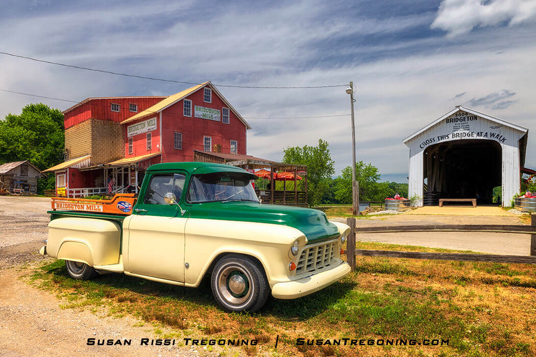
A restored 1955 Chevrolet 3100 pickup sits beside the historic Bridgeton Mill, with the Bridgeton Covered Bridge completing this classic Parke County scene.
Planning Your Trip
The Parke County Covered Bridge map can be found almost everywhere in the county, but on that July 4th holiday trip, I had a hard time finding anyplace open to pick one up. I have created a map at the bottom of this post to aid you with your pre-planning.
I have provided the GPS coordinates for each bridge and use the Parke County bridge numbering system to make this article easier to refer back to.
Do not plan to use your phone for your GPS. My Verizon cell phone GPS only worked while I was in town. Otherwise, it was spotty in some areas and utterly nonexistent in others.
One last FYI: If you stick to the Parke County planned tour routes, you will not see all the covered bridges. Thirteen covered bridges are not included on the covered bridge route tours: 1, 4, 7, 14, 16, 19, 20, 25, 30, 31, 32, 38, 39.
Parke County Visitor Center
401 E Ohio St, Rockville
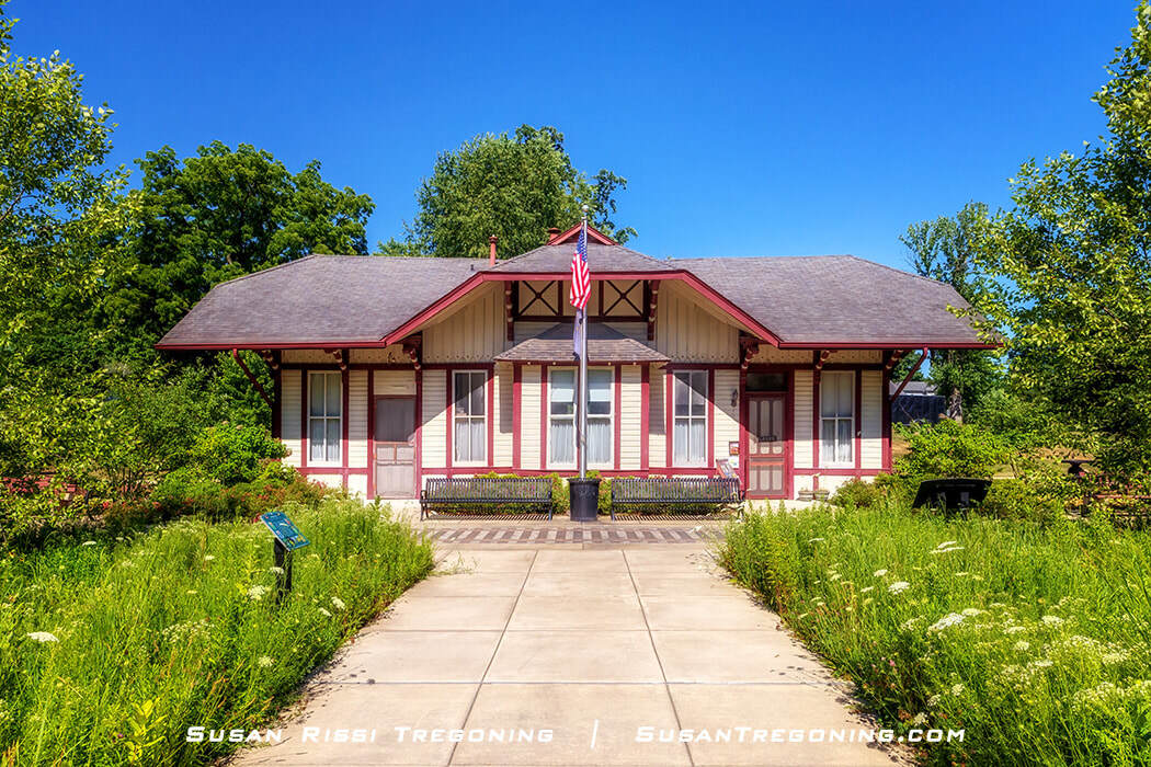
Once Rockville’s train depot, this restored cream‑and‑red building now serves as the Parke County Visitor Center, preserving its early railroad‑era character.
The Parke County Visitor Center is housed in the former Rockville train depot. When you visit, be sure to notice the original railroad track placement simulated on the sidewalk in front of the depot. I love that!
This beautiful depot, constructed in 1883 and known as the Vandalia Railroad Depot, predates the Vandalia Railroad Company’s 1905 merger, which combined several lines in Indiana and Illinois.
The depot had two ticket windows and separate waiting rooms for men and women. The rail service was discontinued in the 1960s, and Parke County Incorporated bought the building in 1971.
The visitor center is the starting point for all five Parke County Covered Bridge routes and the trailhead for the Rails-to-Trails hiking trail on the old railroad right-of-way.
Parke County's 31 Covered Bridges
#1 State Sanatorium Covered Bridge
Country Road 100 N
N 39.780852 W 087.146223
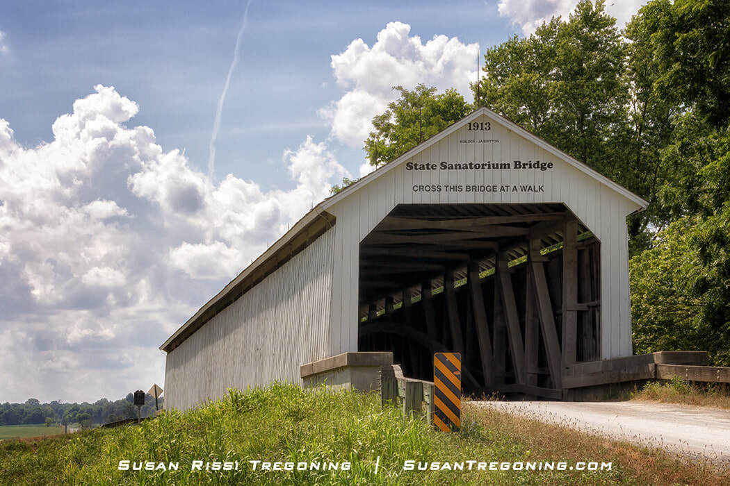
The State Sanatorium Covered Bridge was moved to this location in 2008 and no longer sits on private property. The Covered Bridge Map was updated in 2022, so there may still be old maps out.
The State Sanatorium Covered Bridge is a single-span Burr Arch truss structure that spans 154 feet across Little Raccoon Creek.
It was constructed by J.A. Britton in 1913 and was originally located one mile downstream on the Indiana State Tuberculosis Hospital grounds, AKA the Sanatorium. The bridge no longer sits on private property. It was relocated to this site in 2008 and rehabilitated.
Two other covered bridges have been in this location. The Adams Bridge was destroyed by a flood in 1969 when it washed downstream under the Sanatorium Bridge, and the Jessup Bridge moved here in 1970. The Jessup Bridge was blown off its abutments during high winds in 1989. Flood waters carried it downstream under the Sanatorium Bridge and over the US-36 Bridge.
The Sanatorium, which opened in 1910, used coal to heat its buildings and run the power plant. The hospital had the covered bridge built to create a direct route for hauling coal from the mine in Nyesville, just a few miles away. However, before the bridge’s construction, they needed to backtrack to Rockville and cross the creek at Plank Road Bridge, adding many miles to the trip.
A note about the Sanatorium...
I was unaware of this when I visited Parke County, but The Sanatorium is now available for tours, ghost hunts, and overnight stays. Check out the Sanatorium Project website for more information.
#4 Portland Mills Covered Bridge
Country Road 650 N
N 39.860674 W 087.089213
The white Portland Mills Covered Bridge, shown in profile, reflects in Little Raccoon Creek. Built in 1856, it is the oldest covered bridge in Parke County, Indiana.
The Portland Mills Covered Bridge, at 130-foot long, is a single-span Burr Arch Truss bridge constructed in 1856 by Henry Wolfe. Moved to this location in 1961, it now spans Little Raccoon Creek.
It is one of the two oldest covered bridges in Parke County. The other bridge is Crooks Bridge (#12), which Henry Wolfe also built that same year.
Some of the original bridge siding has been reused on the portals of the Portland Mills Bridge, a white 1856 covered span surrounded by lush summer foliage.
One of the earliest settlers to Parke County was Samuel Steele. He settled in what would become the town of Portland Mills the same year the county was founded in 1821. In 1825, Steele built a mill on Big Raccoon Creek. It was at this grain mill site where the Portland Mills Covered Bridge was located initially.
In 1960, plans were made to expand the Mansfield Reservoir, known today as Raccoon Lake or Cecil M. Harden Lake, for better flood control in the Big Raccoon Creek Valley. This would have meant that the town of Portland Mills would soon be underwater. The bridge was slated for demolition. This was unthinkable, making it imperative that one of Parke County's oldest historic covered bridges, used for preinduction troop training during the Civil War, be moved.
It was decided that the bridge would replace the Dooley Station Bridge on Little Raccoon Creek since it had been destroyed by arson that year. No simple feat, new abutments were poured for the 57-foot longer Portland Mills Bridge. The bridge was moved eighteen miles and reopened in 1961.
Unfortunately, the bridge fell into disrepair because of its secluded location and lack of maintenance. One portal collapsed, and the bridge was closed to traffic in 1982. After that, a bypass ford through the stream was used. It is still there for easy water access today.
Finally, after surviving an arson attempt, Portland Mills Bridge underwent a major $353,000 rehabilitation before reopening in 1996. The truss members remain intact, and some of the original siding was reused for the portals. The remaining yellow poplar siding has been replaced with pine, and the bridge has new cedar shingles. In addition, all the floor beams, stringers, and decking were replaced with contemporary materials, giving the bridge a load-bearing capacity of 13 tons.
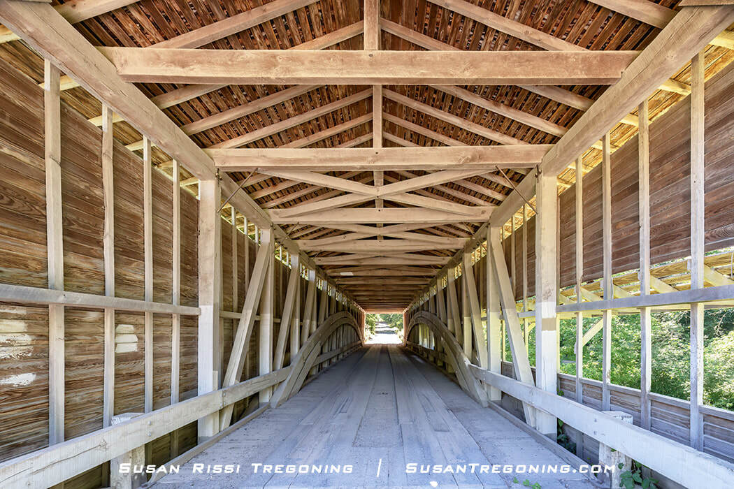
Inside the Portland Mills Covered Bridge, aged timber beams and trusses frame a view of the landscape beyond, highlighting the craftsmanship of this historic span.
Mansfield
#5 Mansfield Covered Bridge & Mansfield Roller Mill
Mansfield Road AKA Mill Road
N 39.675645 W 087.103997
James Kelsey and Francis Dickson built a grinding mill in 1819, using glacial stones quarried nearby to grind corn and wheat. A small community of settlers and businesses grew up around the mill, naming the village New Dublin in honor of their homeland. The village name was later changed to Dickson’s Mills, then Strain’s Mill, before finally becoming Mansfield in the 1830s.
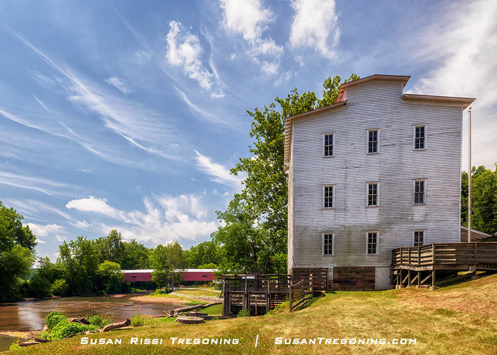
Along Big Raccoon Creek, the Mansfield Roller Mill and the 1867 Mansfield Covered Bridge stand as enduring landmarks of this small Indiana village.
Over the next 46 years, the mill changed hands several times. In 1830, a sawmill was added to the north side of the mill, and sometime later, a carding mill was added to process wool and flax.
Jacob Rohm, a veteran miller, purchased the mill in 1875 after a flood destroyed the dam. He immediately began updating the equipment. In 1880, Rohm tore down much of the old mill and constructed a new turbine mill on the old mill’s foundation.
By 1886, the mill was converted to a roller mill. The roller equipment was automated, and only three men were needed to run the mill. They began grinding wheat into white flour, which was more desirable since it lasted longer.
The Mansfield Roller Mill continued to operate until 1929, producing Victory Flour and shipping it as far away as Cincinnati, Ohio. They also made bran that was sent as far as upstate New York.
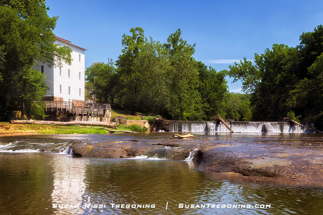
Set along Big Raccoon Creek, the Mansfield Roller Mill remains a defining landmark of this small Indiana village, its historic structure framed by water, rock, and summer greenery.
By 1929, the mill could no longer compete with larger mills and went into receivership. Len Reeves purchased it and converted it into a feed mill and store. Henry Reeves, Len’s son, finally closed it in 1967.
The mill was donated to the State of Indiana in 1995 and is open for tours in the summer and during the Covered Bridge Festival.
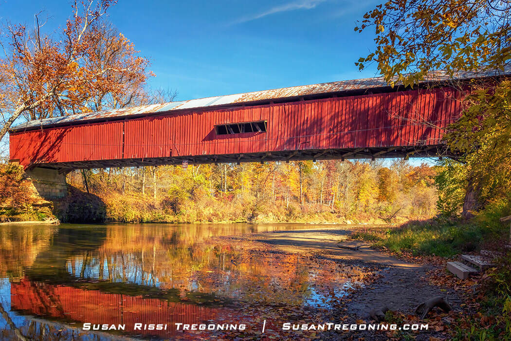
Seen from the creek below, the Mansfield Covered Bridge stretches across Big Raccoon Creek, its red walls and white roof framed by summer greenery.
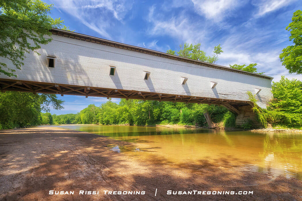
The Mansfield Covered Bridge, a double-span double Burr Arch Truss bridge constructed by J.J. Daniels in 1867, spans 247 feet long across Big Raccoon Creek. It is the fourth oldest and the third longest of the historic Parke County Covered Bridges.
The bridge is located on what was once the historic Indian Trail that connected Orchard Town, now Terre Haute, to Cornstalk, an Indian village in the Sugar Creek Township. It became part of Indiana State Road 59 in 1926, and the bridge was used heavily until IN-59 was rerouted around the edge of Mansfield instead of through it.
There’s a story about the Mansfield Bridge from its State Route 59 days that defines J.J. Daniels’s skill as a bridge builder. Three loaded oil trucks approached the bridge. When the first truck stalled just before exiting the bridge, all three trucks simultaneously ended up on the bridge. Surprisingly, their combined weight did no structural damage to the bridge.
Today, the village of Mansfield has fewer than twenty permanent residents. The bridge is one of the most popular spots during the Covered Bridge Festival and is closed to automobile traffic during the festival.
#6 Big Rocky Fork Covered Bridge
Country Road 720
N 39.662812 W 087.083064
J.J. Daniels built the Big Rocky Fork Covered Bridge in 1900. This 72-foot long single-span Burr Arch truss bridge crosses the creek it was named after. A new bridge was built, and the covered bridge was bypassed in 1987.
The area around the bridge is said to have been a favorite hideout of John Dillinger, the infamous leader of the Dillinger Gang, who was accused of robbing 24 banks and four police stations. He was born in Indianapolis.
#7 Conley's Ford Covered Bridge
Country Road 550 E
N 39.659621 W 087.134197
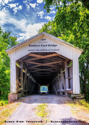
Once built with Daniels Arch portals, Conley’s Ford Covered Bridge now carries Britton Portals after its 1991 renovation, a visible chapter in the evolving history of this 1906 span.
J.L. Van Fossen constructed this single-span Burr Arch truss bridge in 1907 out of white pine instead of using poplar like most other Parke County bridges. At 192 feet long, it is said to be the fourth longest single-span covered bridge in the world.
J.L. Van Fossen and his brother, J.P. Van Fossen, worked closely with J.J. Daniels while working for the Parke County Road Department.
As a result, their bridge construction copied Daniels style, even using the “Daniels Arch” for their portals. A 1991 bridge renovation changed the “Daniels Arch” portals to “Britton Portals.”
Daniels was known to have worked as a foreman on some of their bridges. While I never found any information saying Daniels worked on this bridge, I wouldn't be surprised if he had because of its extreme length.
Bridgeton
#8 Bridgeton Covered Bridge & Bridgeton Mill
8132 Bridgeton Road, Bridgeton
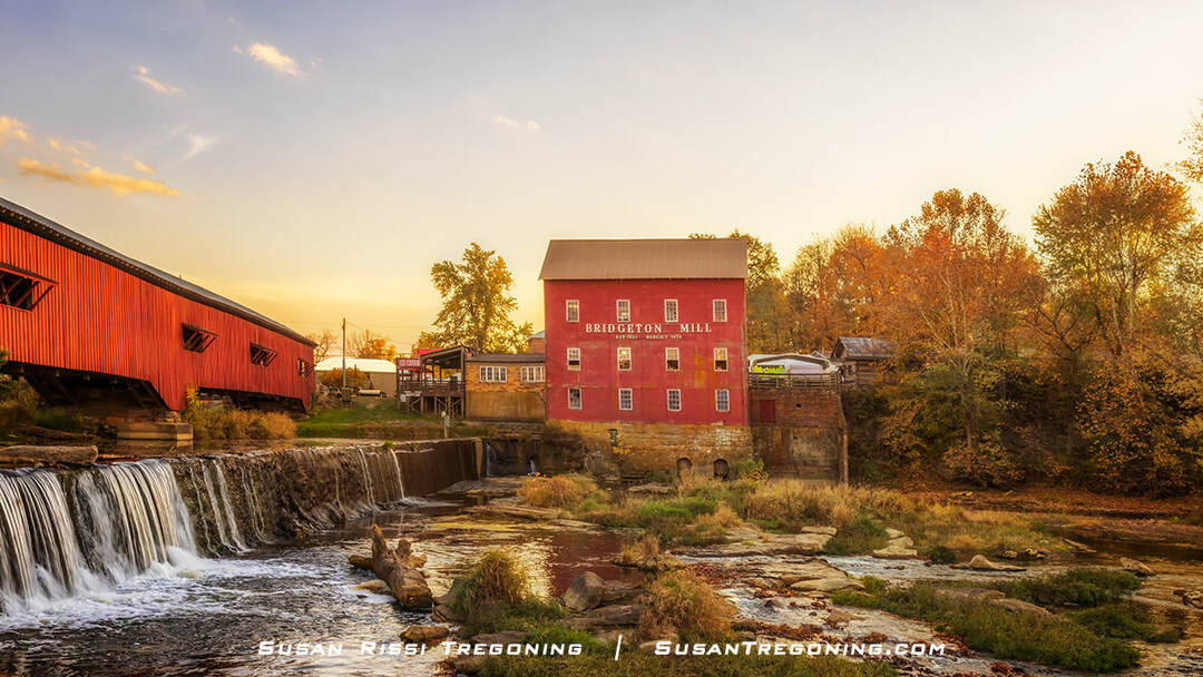
From across Big Raccoon Creek, the Bridgeton Mill and its covered bridge capture the enduring charm of this historic Indiana village, glowing in the warm tones of autumn.
The village of Bridgeton is just south of the Ten O'clock Line. The settlement started when Joseph Lockwood and Issac J. Sillman built a small sawmill along Big Raccoon Creek in 1823. Around 1845, the mill and distillery burned down but were rebuilt in 1848.
At some point, the buhrstone was added to grind corn into corn meal, and since flour wasn’t readily available, they eventually began grinding wheat for bread making, too. That mill changed hands many times before it burned in 1869 and was rebuilt in 1870.
As with all early mills, it was a gathering place to catch up on the news and buy whiskey at the mill distillery. It was a rough and tumble place known for drinking and fighting, often called "Sodom.”
Families began to settle around the mill, and a crude open bridge was built over the Big Raccoon Creek in 1849. After establishing a post office, the women seeking to change the town’s reputation petitioned to rename it Bridgeton after the village's early bridge.
That first bridge had collapsed, dropping Owen Wimmer and his family, along with his wagon and team of horses, into the mill pond. Another open bridge was built to replace it but fell after J.H. Kerr drove his cattle across it. The repetitive pounding of the cattle’s hoofs most likely destroyed that open wooden bridge. A prime example of why the cover bridges are all inscribed with, "Cross this bridge at a walk."
Finally, J.J. Daniels was contracted to build a covered bridge over the mill pond. Sadly, shortly before the new covered bridge was finished in 1868, three men attempting to cross the rain-swollen creek just below the dam overturned their boat, and two drowned. That spot is still dangerous when the water is high.
The historic Bridgeton Bridge was bypassed in 1967. However, it was considered the most photographed bridge in Indiana and possibly the world before an arsonist burned it in 2005.
Dan Collom and the local community rebuilt the 245-foot long double-span double Burr Arch truss bridge in 2006. It is now the only covered bridge in Parke County that is not historical and is no longer listed on the National Register of Historic Places.
The third mill on the site, built in 1870, is the one you see today. It still grinds corn meal and flour with an old-fashioned buhrstone.
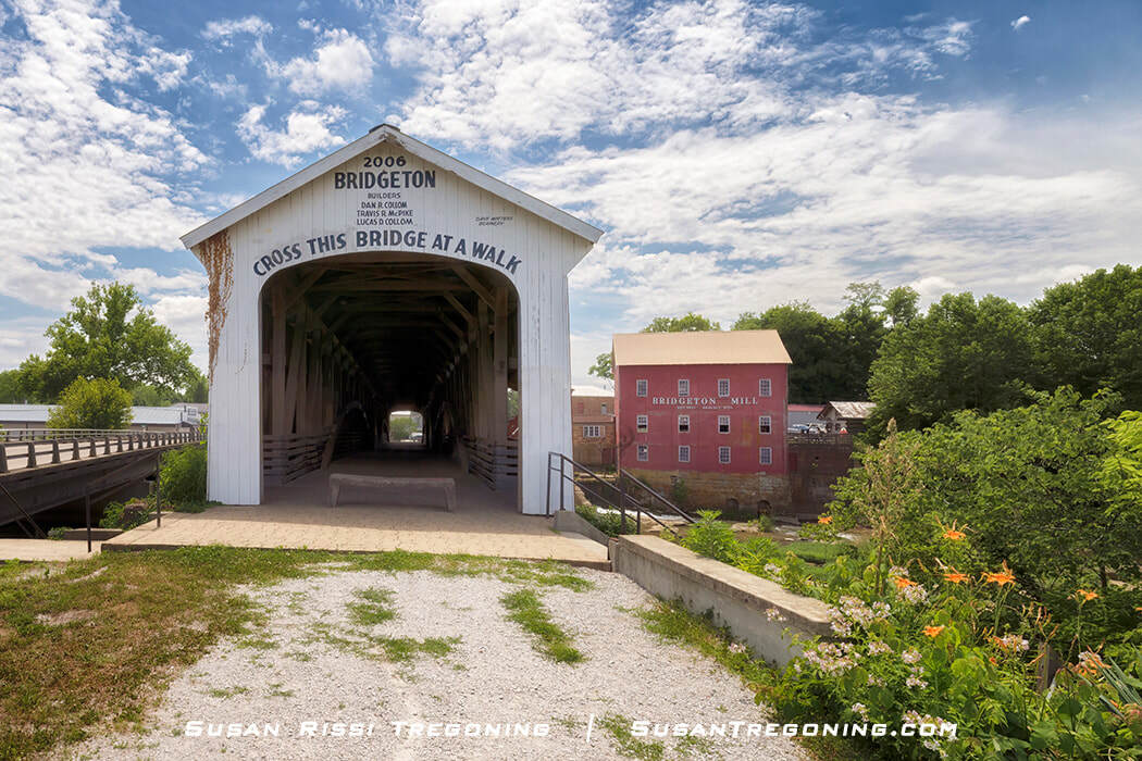
Although rebuilt in 2006, the Bridgeton Covered Bridge still frames a classic view of the historic Bridgeton Mill along Big Raccoon Creek.
While in Bridgeton, don't miss the Old Masonic Lodge...
Since 1869, the old Masonic Lodge, which predates the current mill, has stood in town just across from the mill. It is the oldest building in Bridgeton and one of the last Masonic Moon Lodges left in the country. The Lodge still maintains the tradition of holding meetings on the night of a full moon, so lodge members can easily find their way home by the bright moon’s light. Unfortunately, the building’s third story was removed in 1913.
#10 Neet Covered Bridge
Bridgeton Road
N 39.701723 W 087.200188
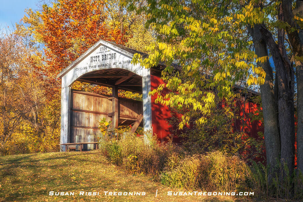
The Neet Covered Bridge, a Burr Arch truss single‑span structure, spans Little Raccoon Creek in Parke County, Indiana.
The Neet Covered Bridge is a Burr Arch Truss single-span bridge spanning 126 feet across Little Raccoon Creek.
Completed in 1904, when J.J. Daniels was 78 years old, this is the last bid for a covered bridge he was awarded.
J.J. Daniels, at 84 years old, may have built the Roseville Bridge in 1910, but nothing can be found to confirm this. J.P. Van Fossen received the contract for the Roseville Bridge and was given credit for building it.
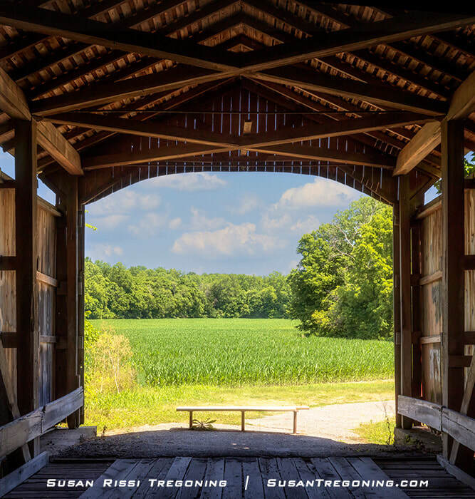
Looking out from inside the Neet Covered Bridge toward a green early‑summer cornfield stretching across the landscape.
#11 McAllister Covered Bridge
Country Road 400 S
N 39.709425 W 087.196306

The McAllister Covered Bridge, featuring its distinctive Britton Portal design, stands in full autumn color.
The McAllister Covered Bridge was constructed in 1914 at the height of J.A. Britton's bridge-building career. At the time, Britton was already 77, and his sons were doing most of the labor.
McAllister Bridge spans 126 feet in length across Little Raccoon Creek and is a single-span Burr Arch Truss bridge. It has several apparent repairs, which have been reinforced with steel. In addition, the abutments, which are wider than the ends of the bridge, are supported with reverse kingposts.

Standing inside the McAllister Covered Bridge in Parke County, Indiana, looking out at the country lane and cornfields is a cool escape from the midday summer heat. This image gives a nice view of those reverse kingposts at the end of the bridge.
McAllister Bridge was named for James D. McAllister, who owned Fairview Hill Farm near the bridge.
In the winter, when the trees are bare, it’s possible to see Neet, McAllister, and Crooks covered bridges simultaneously since they are so close together. With a drone, for a bird’s eye view, you would also be able to see Nevins.
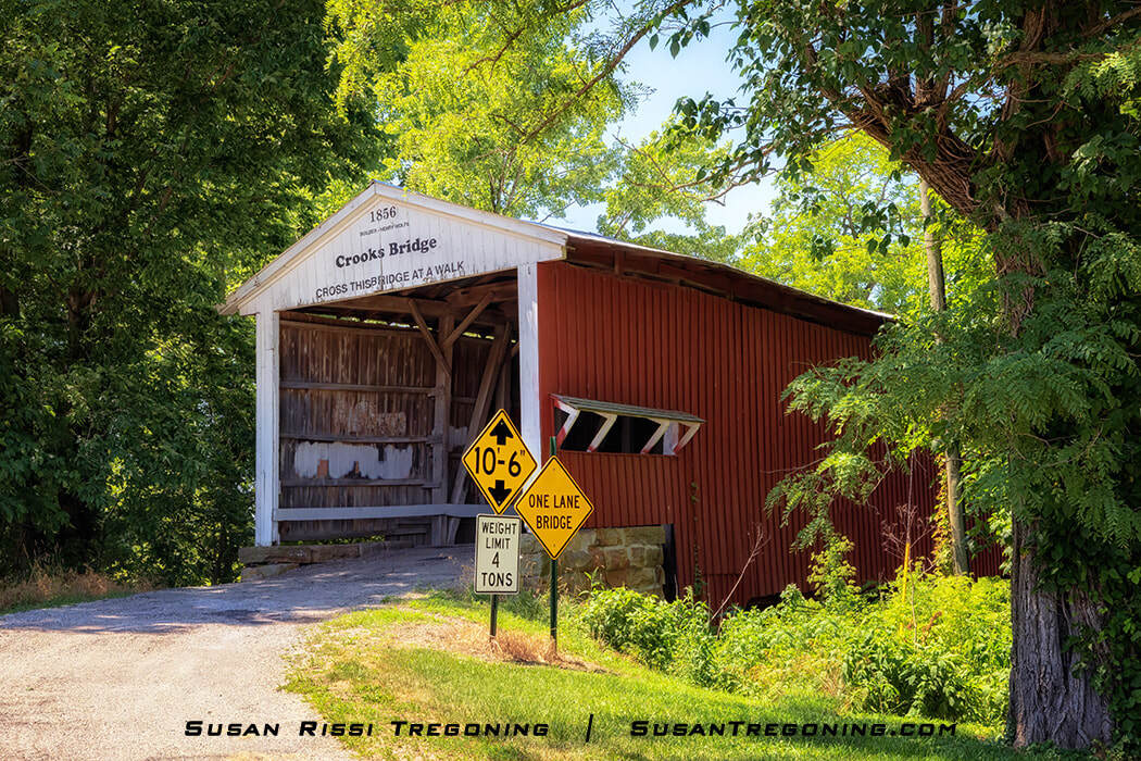
#12 Crooks Covered Bridge
Wimmer Road
N39.723833 W087.189462
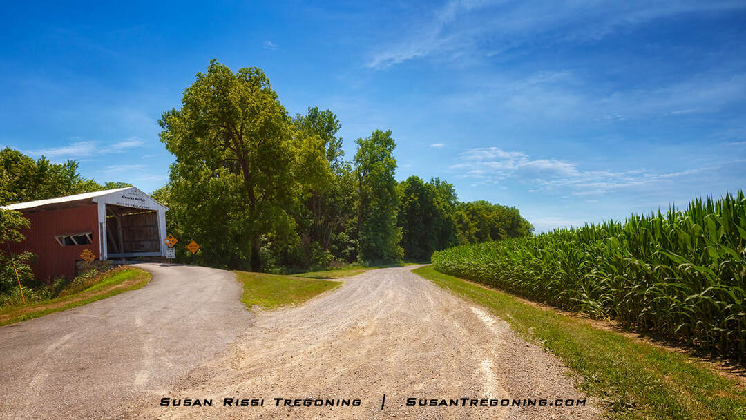
Crooks Covered Bridge sits on a scenic country road.
Crooks Covered Bridge sits on a small hill overlooking a scenic country road and cornfields. It spans 132 feet across Little Raccoon Creek. A single-span Burr Arch Truss bridge, it is one of only two Henry Wolfe bridges still standing.
Crooks Covered Bridge, one of the oldest covered bridges still standing in Parke County, Indiana, framed by lush summer greenery.
That is about all the facts anyone is sure about, as the history of this bridge is very murky.
Crooks Bridge was initially thought to have been built in 1855-56, which would have made it slightly older than Portland Mills Bridge, but its build date has since been changed to 1856.
Sometime after 1863, the bridge was moved to this location. Some say the bridge washed downstream to where it sits today, was jacked up, and the foundation rebuilt under it. Others claim the creek changed course, and the bridge was moved here because a bridge was needed. I have even read a claim that this is the only bridge still on its original foundation.
Other claims suggest that the bridge was rebuilt in either 1867 or 1872, possibly by General Arthur Patterson, one of Rockville's founders, or that he hired J.J. Daniels to reconstruct it.
While trying to flesh out the facts, the Parke County Commissioner's records dating from 1850 discuss needing a bridge and, in 1855, ordering a bridge to be built on the old Rockville Greencastle Road. But, at the same time, an old topographic map shows an intermittent stream about in the location of an old creek bed where the bridge may have once sat, the channel filled with sand, and the creek “moved 20 rods west.” Since both of the above statements can be substantiated, it seems more likely that the histories of two or maybe even three bridges have somehow gotten intertwined. After 150+ years, I doubt anyone will ever know the true history of this covered bridge.
Crooks Covered Bridge shown in profile as it spans Little Raccoon Creek, surrounded by lush summer greenery.
#13 Caitlin Covered Bridge
Parke County Golf Course
1640 US Hwy 41, Rockville
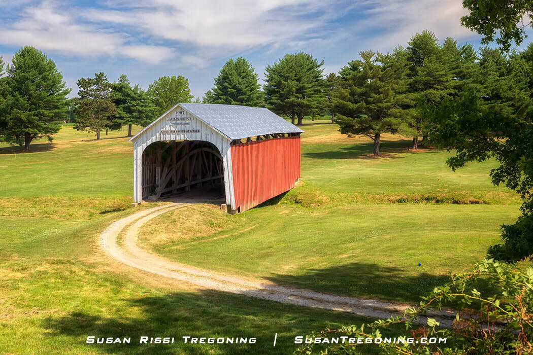
Catlin Covered Bridge, now located at the Parke County Golf Course in Rockville, Indiana.
The Catlin Covered Bridge moved in 1961 and now resides at the Parke County Golf Course in Rockville. It spans Bill Diddle Creek, a stream named after the golf course designer.
Clark McDaniel constructed this 54-foot-long single-span Burr Arch truss bridge in 1907. Initially located in the town of Catlin Station, it sat on the road to Crawfordsville, a significant route known as “Ben Hur Highway,” named for General Lew Wallace, who was Crawfordsville’s most famous resident and author of the novel, “Ben Hur.” Even after US 41 bypassed the bridge, it continued to be used by heavy farming trucks. Until finally neglected and in severe disrepair, the bridge was condemned shortly after the Covered Bridge Festival began in 1957.
Funds were raised to move the bridge to the golf course, and Garrard Brothers Trucking completed the move. Once at the golf course, the bridge again sat neglected for several more years until golfers began lobbying for it to be demolished. Finally, a foundation was constructed, and the bridge was restored.
#14 Nevins Covered Bridge
Country Road 130 E
N 33.684514 W 087.212636
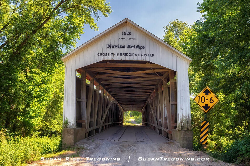
Nevins Covered Bridge was the final covered bridge to be built by J.A Britton and the final historic bridge to be constructed in Parke County.
Constructed by J.A. Britton & Son in 1920, the Nevins Covered Bridge ended an era. It was the last covered bridge built in Parke County until Bridgeton Bridge was replaced in 2006. It is also the final bridge that J.A. Britton built. While J.A. Britton, who was 83 years old at the time, is credited with creating this bridge, it was most likely his son Eugene who did most of the construction.
A single-span Burr Arch bridge, it is 155 feet long and spans Little Raccoon Creek. It has “Daniels Arched Portals” instead of the “Britton Portals” that J.A. Britton and his son Eugene Britton preferred.
Nevins Covered Bridge in profile spanning Little Raccoon Creek.
#16 Thorpe Ford Covered Bridge
Catlin Road
N39.637367 W087.264600
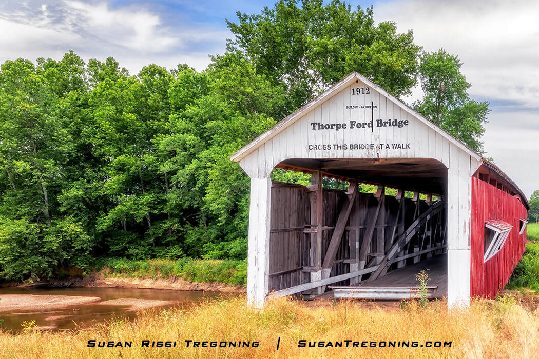
Thorpe Ford Covered Bridge spans Big Raccoon Creek in Parke County, Indiana, surrounded by lush summer greenery.
J.A. Britton built the 163 feet long single-span double Burr Arch truss Thorpe Ford Covered Bridge across Big Raccoon Creek in 1912. It sat on the Ben Hur highway, a major route between Terre Haute and Crawfordsville. The road was named in honor of Crawfordsville’s most famous resident, General Lew Wallace, the author of the novel Ben Hur. Automobile traffic was diverted when State Highway 41 was constructed, but heavy farm trucks continued to use the covered bridge until 1960 when it was condemned. The bridge was bypassed the following year.
The County Commissioner, J.M. May, is said to be responsible for getting this bridge built. There is a story about him that took place right after his election. When attempting to travel from Rosedale to Rockville, he wanted to take a faster route instead of traveling through Coxville. Unfortunately, the directions he was given were so convoluted that he was lost for hours and vowed to build a new bridge, which would make the trip more direct.
Thorpe Ford Bridge is named after an early Ford across the Big Raccoon Creek and Sarah Thorpe, who owned 92 acres of land next to the bridge in 1920. Her son, Dan, still lived near the bridge in 1948, but according to early Parke County road maps, the Ford’s location is thought to have moved at least a ¼ mile in the last 100 years.
Benjamin Wallace, a native of Peru, Indiana, who owned the second-largest circus in the country from 1892 to 1938, crossed the Thorpe Ford with his animals each year when they returned home to Peru for the winter.
#18 Roseville Covered Bridge
Country Road 345 W
N 39.652376 W 087.293817
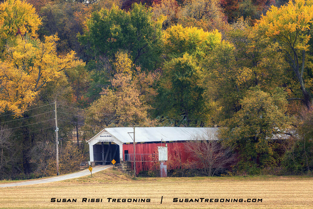
Fall colors surround the Roseville Covered Bridge, creating a vibrant autumn frame around the historic span.
The 1910 Roseville Covered Bridge is a 263-foot long double-span Burr Arch Truss bridge across Big Raccoon Creek in Coxville. It is the second bridge in this location. J.J. Daniels built the first Roseville Covered Bridge in 1865, but unfortunately, it was destroyed by arson in 1910.
When Parke County began accepting bids for its replacement, they initially wanted a concrete bridge. Instead, J.P. Van Fossen was awarded a new covered bridge contract.
Eyewitnesses from the construction site in 1910 claimed that J.J. Daniels was the on-site foreman for the new bridge. If this is true, he would have been 84 years old when he built the second Roseville Covered Bridge. Unfortunately, nothing can be substantiated, and whether or not Daniels was involved in constructing this bridge remains a mystery. A photo taken when the bridge was almost completed shows a portal inscription giving J.P. Van Fossen credit as the contractor while J. Brooks is credited as the builder, but onsite witnesses say Brooks never worked on the bridge. A later photograph shows a different inscription giving J.J. Daniels credit, but today, J.J. Daniels's name is no longer there, and credit is given to Van Fossen.
Since the new bridge was a different length, new abutments had to be constructed. By 1900, most covered bridges had poured concrete abutments, and the Van Fossen brothers were known to have used concrete abutments on all their other bridges. Interestingly, the new abutments were constructed out of stone, in typical J.J. Daniels construction fashion. There is even a photograph commemorating the first stone for the 1910 bridge being loaded on the back of a horse-drawn wagon.
The portal opening initially had the “Daniels Arch,” but it was later changed to a "Britton Portal.” This may have been adapted if the sign boards were too low and more clearance was needed.
In 1890, the town’s name changed from Roseville to Coxville, so Roseville Covered Bridge is sometimes called Coxville Bridge. By the 1950s, only a few homes and the Coxville Tavern remained.
Tex's Longhorn Tavern, or the Coxville Tavern as it was known locally, was owned by Coxville native Edward Earl Terry. He's better known as the actor Tex Terry, who played the villain in many Western movies in the 1940s and 50s. After retiring from acting, he moved home and opened the tavern in a small log building with a stone fireplace that locals say resembled a Snuffy Smith Comic Strip scene. Terry was instrumental in developing Mansfield.
Another interesting character from Coxville is Doc Wheat. An herbalist who practiced near the bridge's west portal, he was well known for his distrust of banks. However, after his death, treasure hunters searching for Mason jars full of money dug up the yard around his house.
#19 Harry Evans Covered Bridge
Country Road 325 W
N 39.66211 W 087296643
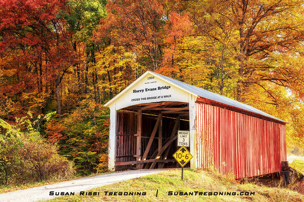
Harry Evans Covered Bridge framed by vibrant autumn foliage in Parke County, Indiana.
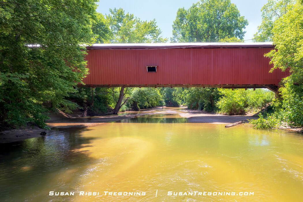
J.A. Britton built the Harry Evans Covered Bridge, a 65-foot long single-span Burr Arch Truss bridge across Rock Run Creek in 1908, along with two other bridges that same year. The Zacke Cox still exists, but a flood destroyed the Weiser in 1957.
The bridge is named after Harry Evans, who owned the land near it when it was built. The property stayed in the Evans family until sometime in the 1960s.
#20 Zacke Cox Covered Bridge
Tick Ridge Road
N 39.695039 W087.288037
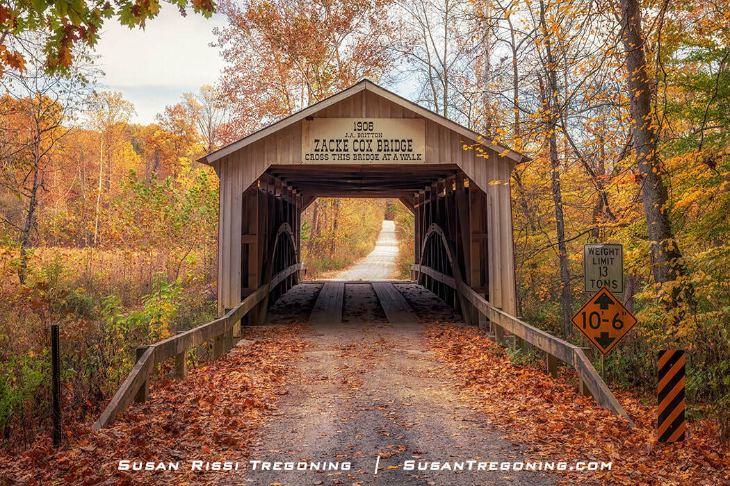
#20 Zacke Cox Covered Bridge framed by autumn foliage in Parke County, Indiana.
Built by Joseph A. Britton in 1908, the Zacke Cox Covered Bridge is a 54-foot long, single-span Burr Arch Truss bridge spanning the Rock Run Creek. It was named after Zachariah M. Cox, born in 1857 to a prominent Parke County family that owned nearly 1000 acres of land near the bridge.
The Zacke Cox and Harry Evans Covered Bridges sit about 1.6 miles apart as the crow flies on the Rock Run Creek. There was another road between the two bridges at one time, but that road was never bridged and was finally abandoned. Also located between the two bridges is an ancient Indian grave, once marked with a snake-like fossil and hewn rock steps. The cliffside has since collapsed, covering the entrance to the grave.
During the Carboniferous Period, AKA the Age of Coal, approximately 290 to 360 million years ago, Parke County was covered by a shallow sea. As a result, many exciting shark and bony fish fossils have been found in the area. The most notable discovery happened in 1956 when Dr. Rainer Zangerl discovered the first twelve-foot-long Orodus Greggi shark fossil north of the bridge.
#21 Mecca Bridge & Mecca Schoolhouse
Mecca Road
N 39.729126 W 087.327280
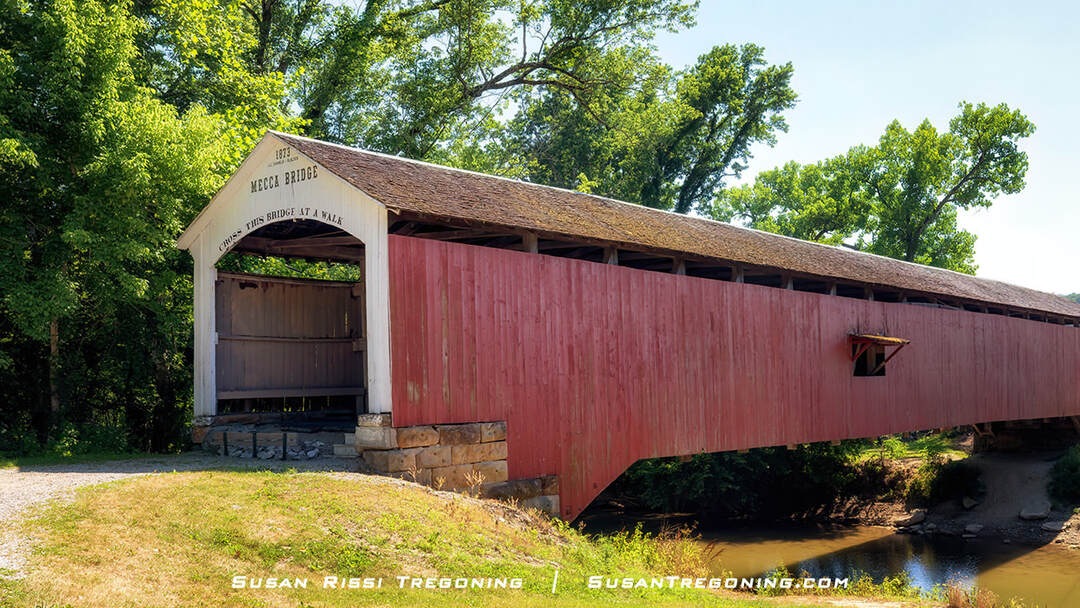
Mecca Covered Bridge, the 1873 span set over Little Raccoon Creek and framed by lush summer greenery.
J.J. Daniels constructed the 150-foot long single-span Burr Arch Truss Mecca Covered Bridge across the Big Raccoon Creek in 1873. It is so well-constructed that the bridge has survived four significant floods: 1875, 1913, 1957, and 1990. The worst floods were in 1957 and 1990 when the floodwaters rose above the bridge floor. The bridge was bypassed in 1965 and restored in 1993.
In 1966, the Mecca Historical Society purchased Wabash Township School Number 3 and moved it to the west side of the Mecca Covered Bridge. Initially constructed in 1874, the one-room schoolhouse stood vacant for decades before being renovated in 2021. It is now used for special events throughout the year. Check out the Mecca Historical Society’s Facebook Page for more event information.
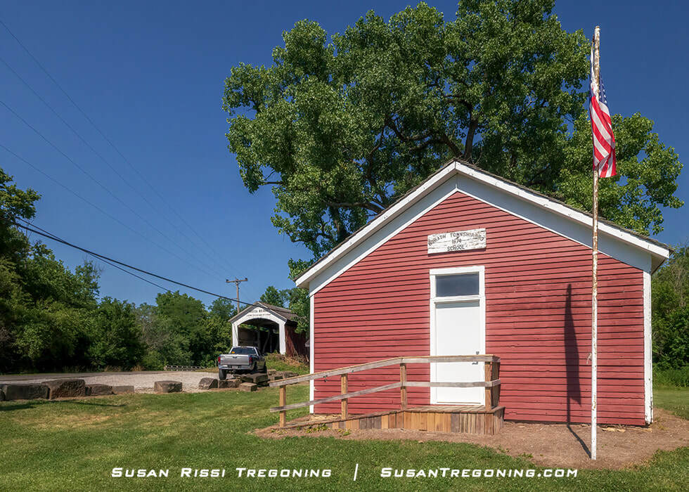
The Wabash Township Number 3 one‑room schoolhouse stands beside the Mecca Covered Bridge, a pair of historic landmarks set amid lush summer greenery.
Today, the quiet little town of Mecca has fewer than 300 people, but at the end of the 19th Century, it was a center of industry, with a population closer to two thousand.
Around 1827, a group of Syrian Muslim immigrants known as “Bani Ismail” or the Tribe of Ishmael settled on Big Raccoon Creek's white sand and clay banks about four miles away from Mecca. Their lineage would become some of the first American Muslims.
The Parke County area where they lived became known as Little Arabia. Located not far from the Philips Covered Bridge, all that remains of Little Arabia today are the ruins of the Arabia Church and a Cemetery at the top of the hill. Sadly, the Arabians, as they were called at the time, were forcibly removed from the area along with most of the Native American Indians.
What would eventually become the town of Mecca got its start in 1832 when a sawmill was built on Big Raccoon Creek by Alexander McCune and Samuel Lowery. The following year, they added a carding mill, and in 1834, machinery for fulling cloth. With the Wabash and Erie Canal nearby, the partners were also building flatboats and packing pork for shipment to New Orleans. Finally, in 1855, they added a flour mill. The town was named Maidstone at the time, and it was growing into a flourishing community that soon had a grain elevator, two hotels, two bakeries, a bank, a pool hall, a blacksmith shop, a hardware store, a newspaper, four churches, and the mines.
Each Spring, as soon as the roads were passable, the Arabians would travel into town to visit McCune’s Store to purchase supplies. McCune, known for his quick wit, is said to have remarked that “the Arabians were making their annual pilgrimage to Mecca.” It is thought that maybe the name just stuck, and in 1888, the town changed its name from Maidstone to Mecca Mills. By 1894, the name was shortened to just Mecca.
Between 1877 and 1879, a new road that would eventually become part of US-41 was constructed between Maidstone and Rockville, making travel easier between Parke County’s two largest towns. The road crossed the Big Raccoon Creek at the covered bridge, and the town began to expand westward.
In 1895, William E. Dee, originally from Chicago, moved to Mecca and opened the Indiana Sewer Pipe Company and several clay plants. His three companies alone employed nearly 300 people. He also opened and was President of the Bank of Mecca.
By 1900, the mills had closed, and the village of Old Mecca began to decline, but the new section of town was expanding to the west of the covered bridge about ½ miles away on Indiana Coal Road. The train station of the recently bankrupt Indiana Coal Railroad, a branch of the Chicago and Eastern Illinois Railroad that became part of B&O, was the first building in the new town.
When the Great Depression hit, the Bank of Mecca was the first business to close. Then, the grain elevator, sawmill, and Dee’s factories shut down. Mecca ended up being Parke County's hardest-hit town, with over 200 Mecca families going on relief the same day. The closures completely decimated the town, with everyone moving away to find work.
#22 Phillips Covered Bridge
Arabia Road
N 39.77227 W 087.32244
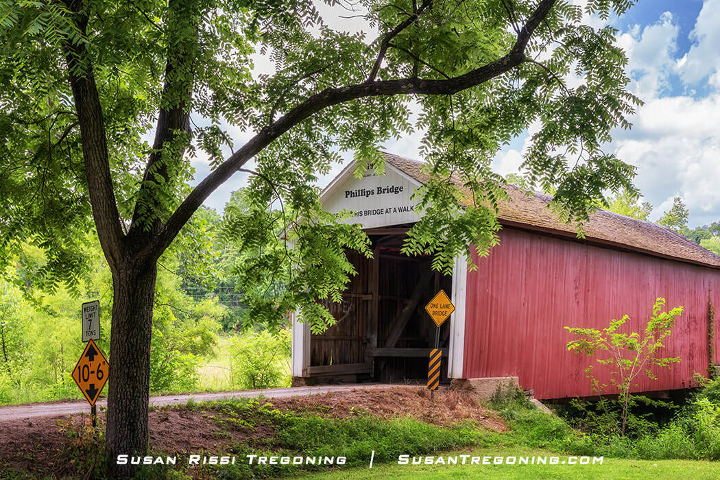
#22 Phillips Covered Bridge set along a quiet rural road and framed by lush summer greenery in Parke County, Indiana.
The Phillips Covered Bridge, AKA Arabia Covered Bridge, crosses Rocky Run Creek. Built by J. A. Britton in 1909, this single-span four-segment King Post Truss bridge at 43 feet is the shortest covered bridge in Parke County and the only remaining bridge that is not a Burr Arch Truss.
When the bridge was built, the Phillips family owned all the property surrounding it. However, the area was often called “Little Arabia” since a group of Syrian Muslim immigrants settled there. The Arabia Church ruins, and a cemetery sits on the hill just south of the covered bridge.
#23 Sim Smith Covered Bridge
Country Road 40
N 39.773610 W 087.33344
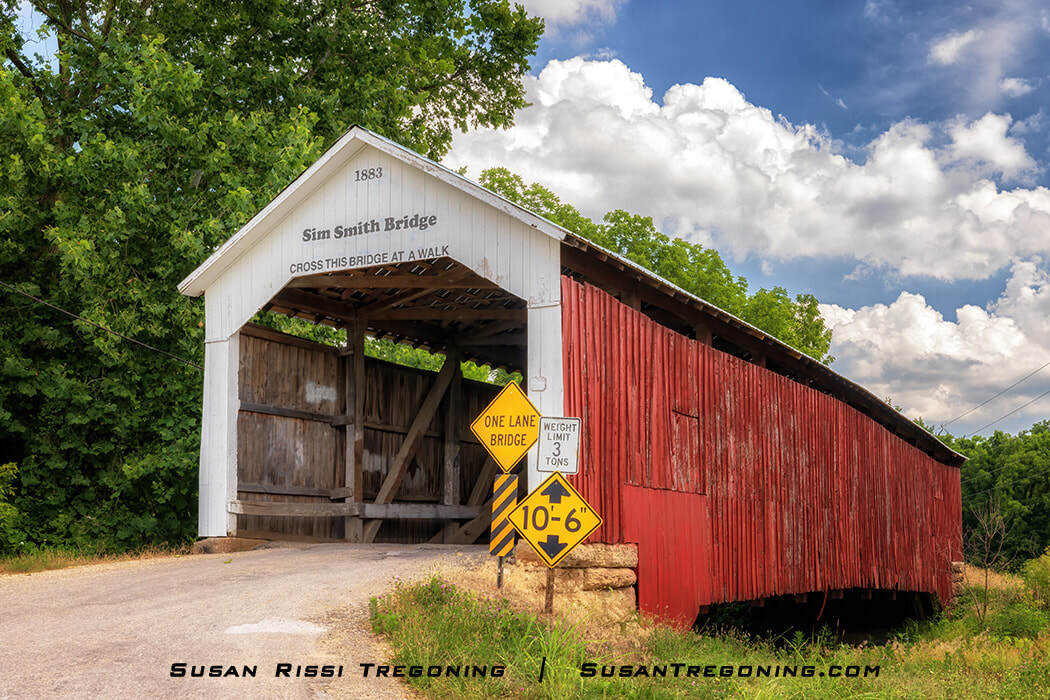
Sim Smith Covered Bridge, the 1883 span set along a quiet rural road and framed by lush summer greenery.
Constructed in 1883 by J.A. Britton, the 84-foot-long Sim Smith Covered Bridge is a single-span Burr Arch Truss bridge spanning Leatherwood Creek. It was named for the landowner, Simeon Smith, whose descendants retained the property through 1990.
J.A. Britton was awarded this contract with a bid of $3200, beating J.J. Daniels by $300. This is only the third covered bridge that Britton built, and the burr arch is considered relatively primitive compared to Daniels’s perfectly curved ones. Examining the arch, you can tell he was still learning bridge building since it has incomplete cut segments. Britton’s later bridges are said to have achieved an attention to detail and craftsmanship that exceeded J.J. Daniels’s quality.
While Britton built this bridge initially with his trademark “Britton Portal,” at some point over the years, the north portal was modified to a “Daniels Arch,” while the south portal is still correct.
Sim Smith Bridge is said to be one of the most haunted places in Indiana. According to local lore, in 1890, a young woman carrying her baby was walking home to Montezuma at dusk one night. As she approached the bridge, a horse and buggy exited, striking and killing the woman and infant.
The ghosts of the mother and child are said to haunt the bridge. Some people claim they have seen a woman carrying an infant in the shadows of the bridge, while others have said they heard the clopping of horse hooves but never saw any horses. Some local fishermen claim they saw a horse and buggy enter the bridge, but it never came out the other side.
If you experience something paranormal when you visit the bridge, please let me know in the comments. I love a good ghost story!
#24 Melcher Covered Bridge
Strawberry Road
N 39.789101 W 087.335098
When I visited, Melcher Bridge was closed to all traffic.
Constructed in 1896 by J.J. Daniels, Melcher Covered Bridge is an 83 feet long single-span Burr Arch Truss bridge that spans Leatherwood Creek a mile east of Montezuma, Indiana. The original hewn limestone and shale abutments, which have crumbled with age, are now encased in concrete.
This covered bridge has had many different names over the years and was most likely constructed for easier access between the Marion Brick Plant, which closed in the 1920s, and the Klondyke Clay Mine, which mined the clay for the plant. For this reason, it was sometimes called the Marion Bridge and other times known as the Klondyke Bridge. In addition, some people referred to it as Leatherwood Bridge since it spanned Leatherwood Creek. However, this was extremely confusing since the Leatherwood Station and Leatherwood Ford bridges were nearby.
Today, this covered bridge is known as the Melcher Bridge and is in honor of the Melcher Railroad Station. From 1846 to 1917, two Cincinnati, Hamilton, and Dayton Railway lines crossed just west of the bridge. That railroad was acquired by the B&O Railroad in 1917.
#26 West Union Covered Bridge
Tow Path Road
N 39.856153 W 087.335713
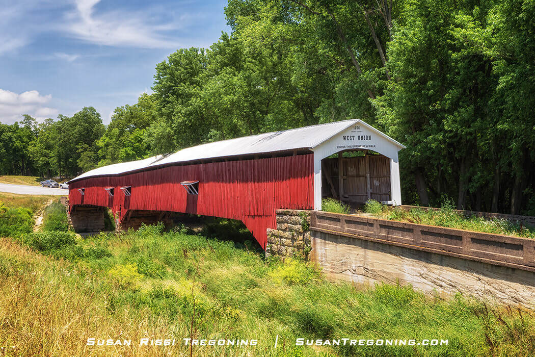
The south portal of the West Union Covered Bridge, the 1876 span crossing Sugar Creek near Montezuma, Indiana.
At 315 feet long, the West Union Bridge is the longest remaining Parke County covered bridge and the third double-span Burr Arch truss-covered bridge to be built in this location by J.J. Daniels. Both visually impressive and structurally intact, the West Union Bridge is considered one of the nation’s best-preserved examples of a Burr truss bridge.
The first bridge, constructed in 1861, was the Star Mill Bridge. After a flood destroyed it in 1866, construction of the Harrison Bridge followed that same year. While the Harrison Bridge was damaged in the flood of 1875, it was thought to have stood when Daniels completed the West Union Bridge in 1876. These bridges were part of the “Indiana State Highway,” a stagecoach route running between Fort Wayne and Terre Haute, that the legislature established in 1827.
The West Union Bridge was longer than the previous two bridges, and new, wider abutments had to be constructed. These abutments were damaged and repaired in 1913 and 1931. Also, in 1931, the bridge received a new poured concrete approach on its south side. While the south portal of the bridge still features the famous Daniels Arch, at some point, the north portal was squared off. West Union Bridge was finally bypassed in 1964.
The bridge spans Sugar Creek, a tributary of the Wabash River. As the closest covered bridge to the mouth of the Wabash, more water passes under this covered bridge than any of the other Parke County covered bridges, making it a popular floating location when the water is calm.
Although little evidence remains today, the Wabash and Erie Canal once ran just west of the bridge, and when the railroad arrived in the area, it crossed Sugar Creek to the east of the bridge.
Sugar Creek flows beneath the long West Union Covered Bridge, a favorite summer float spot framed by sandy banks and lush green trees.
#28 Jackson Covered Bridge
Bloomingdale Road
N 39.880089 W 087.284652
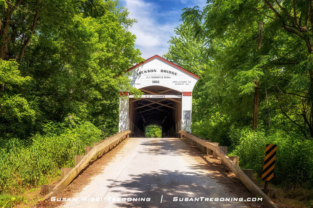
Jackson Covered Bridge in Parke County, Indiana — the 1861 J.J. Daniels span widely regarded as the finest work of his career.
The 207-foot-long Jackson Covered Bridge spans the Sugar Creek. Built in 1861, it is the longest single-span covered bridge in Indiana and the longest single-span wood truss bridge that still carries vehicular traffic in the nation.
This was the first covered bridge that J.J. Daniels constructed in Parke County, and it is widely considered the best bridge of Daniels’s entire career.
Inside the Jackson Covered Bridge, revealing its single‑span structure with double Burr Arch trusses and double King Post framing along the length of the passage.
An absolute masterpiece! This single-span double Burr Arch Truss double King Post bridge has plenty of windows to illuminate the fine craftsmanship on the inside, so you can’t miss his graceful, perfectly curved double arches.
The south upstream abutment contains a cornerstone that reads, “Builder J.J. Daniels 1861”, ensuring that everyone knew and never forgot that he built this bridge. This is the only bridge he ever placed his name on.
J.J. Daniels may have just been showing off when he built this one, but that was a smart business move, considering he was new to Parke County and unknown to the locals. This bridge opened the doors for all his future Parke County bridge contracts.
The Jackson Covered Bridge in profile, the long 1861 J.J. Daniels span crossing Sugar Creek amid lush summer greenery.
Unlike most covered bridges, this was not named after the local landowner. Built at the beginning of the Civil War, Daniels chose to honor Andrew Jackson instead. Even a hand-lettered political statement above the portal: “The Federal Union: It must be preserved.” Likely paraphrasing Andrew Jackson’s quote: “To the Union, it must be preserved.”
While Jackson Bridge is the name that stuck, the locals also referred to it by two other names. Rockport Bridge, after the long-forgotten village of Rockport. The town consisted of Wright’s Mill, a general store, a cooper shop, a blacksmith shop, two sawmills, and four homes. It was also known as Wright’s Mill Bridge, but the mill was gone by 1894, dynamited after its dam washed out in 1882.
#29 Marshall Covered Bridge
Country Road 800 N
N 39.88364 W 087.32657
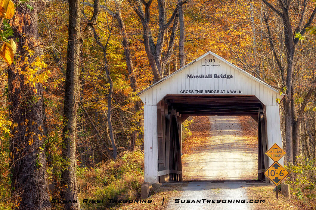
Marshall Covered Bridge in Parke County, Indiana, framed by golden autumn foliage along its quiet rural approach.
Although there is a town named Marshall in Parke County, it is at least 10 miles away from Marshall Covered Bridge. Some think the Marshall Bridge may have been named after Mahlon Marshall, a Civil War veteran, and the Parke County Commissioner when the current Parke County Courthouse was built in 1879. But like most covered bridges, it was most likely named after the nearest landowner. That would have been David W. Marshall, owner of the 132-acre Hill Crest Valley Farm.
Constructed in 1917, Marshall Bridge spans 56 feet across Rush Creek. This is the next to last covered bridge built by J.A. Britton and his sons. Britton would have been 80 years old at the time.
#30 Rush Creek Covered Bridge
Country Road 900 N
N 39.898875 W 087.314746
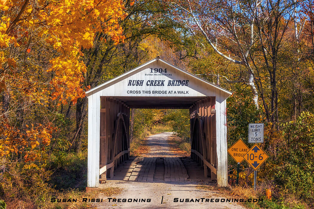
Rush Creek Covered Bridge, the 1904 Wm. Hendricks span set along a quiet gravel road and framed by golden autumn foliage.
William Hendricks was awarded the first of his three covered bridge contracts for the Rush Creek Covered Bridge.
Completed in 1904, Rush Creek Covered Bridge is a single-span Burr Arch truss bridge that spans 77 feet across Rush Creek. It has incredibly shallow portals.
Rush Creek Covered Bridge is located just south of the unincorporated village of Tangier, Indiana. Tangier was named after Tangier, Morocco, Africa, but also known as Long Siding and Woody's Corner. The village started in the spring of 1886 when the Indiana Coal Railroad built a station and the post office opened. A flour mill was built sometime before 1900 but didn’t last long. By 1900, there was a hotel, a canning factory, a grocery and dry goods store, and a hardware store. Unfortunately, the railroad went bankrupt by the end of 1921, and the hardware store burned down in 1924. The Post Office finally ceased operations in 1994. Today, the population is around 500.
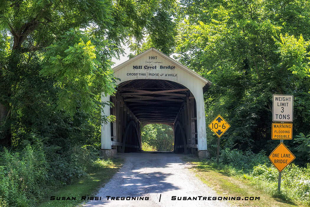
#31 Mill Creek Covered Bridge
Tow Path Road
N 39.908535 W 087.363055
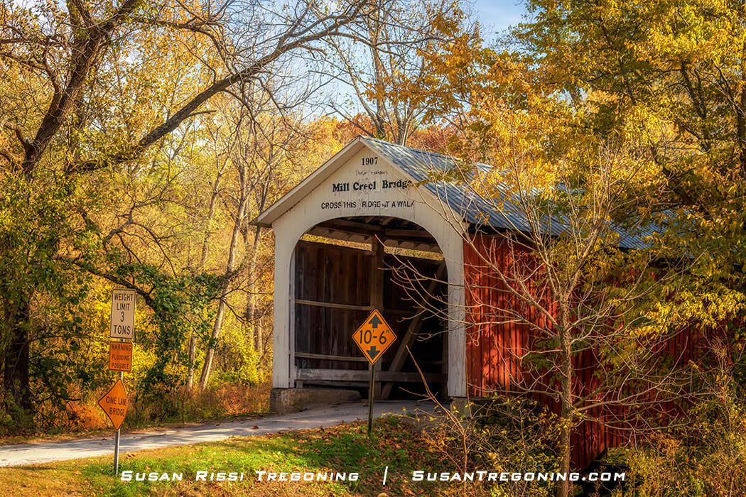
Autumn at the Mill Creek Covered Bridge southwest of Tangier, Indiana, one of Parke County’s 31 historic covered bridges.
Constructed in 1907 by D.M. Brown, Mill Creek Covered Bridge is a single-span Burr Arch Truss covered bridge that spans 92 feet across the (Wabash) Mill Creek.
J.J. Daniels, 81 at the time, submitted a bid for this bridge, but D.M. Brown was awarded the contract. This would be Brown’s only covered bridge. He was inexperienced in bridge building and had so much trouble getting started that he hired William Hendricks to help build it.
Before the bridge became known as Mill Creek Covered Bridge, it was known by three other names: Thompson’s Ford Covered Bridge, Earl Ray Covered Bridge, and Tow Path Covered Bridge:
Thornton Thompson was the nearest landowner when the bridge was built, but the bridge site’s name, Thompson’s Ford, predates him. This location was named for Joseph Thompson, owner of Russell’s Mill, a small wheat flour mill built nearby in 1829. After the mill dam washed out in 1888, it was not rebuilt, and nothing remains of Russell’s Mill today, but it was once located between the two covered bridges on Mill Creek – Bowsher Ford Bridge and Mill Creek Bridge.
It was called Earl Ray Covered Bridge for a short time to honor Earl Ray, a well-known auctioneer and prominent Parke County citizen.
It was also called the Tow Path Covered Bridge because the Wabash & Erie Canal once intersected Mill Creek just south of the covered bridge. When the canal’s towpath between the towns of Montezuma and West Union became Tow Path Road, this bridge was built as the Tow Path Road crossing over the creek. After the canal was drained but before the bridge was built, the old canal aqueduct was sometimes used to cross the creek.
Mill Creek began changing its course by cutting a new path east of the bridge. Water crashing into the northeast abutment has required it to be supplemented with a wood pile wall. In addition, rot at each end of its arches has made it necessary to add wood and I-beam supports to either end of the bridge.
Summer at the Mill Creek Covered Bridge, the 1907 J.J. Daniels span set along a quiet wooded road and framed by lush green foliage.
#32 Bowsher Ford Covered Bridge
Bowsher Road
N 39.929790 W087.353993
Bowsher Ford Covered Bridge seen from afar, the red span set among rolling fields and autumn trees along its quiet rural approach.
The Bowsher Covered Bridge is a 72-foot long single-span Burr Arch Truss-covered bridge that spans Mill Creek. It was constructed by Eugene Britton, J.A. Britton’s son, in 1915. The bridge is named for the Bowsher family, who owned the land around the Ford.
Elmer Garrard initially won the bid for this bridge, beating out J.A. Britton & Sons for the job. However, he lacked the expertise to build it and needed a Britton to get the job done. So Garrard hired Eugene Britton, giving him credit as the builder.
In the meantime, J.A. and Lawrence Britton were busy building three other bridges that year. They completed two bridges in Putnam County and Jeffries Covered Bridge, a Parke County bridge that once spanned Big Raccoon Creek but was destroyed by arson in 2002.
In 1920, Garrard again competed against the Britton family for the Nevins Covered Bridge contract but was unsuccessful the second time.
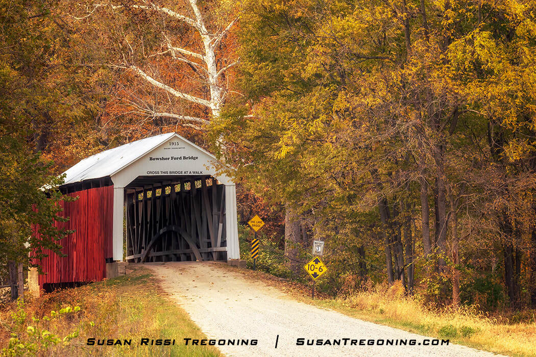
Autumn at Bowsher Ford Bridge, the 1915 red‑sided span set along a quiet rural road and framed by vibrant fall foliage.
#35 Wilkins Mill Covered Bridge
Cox Ford Road
N 39.898176 W 087.232216
Wilkins Mill Covered Bridge, built in 1906, was the second of three bridges constructed by William Hendricks in Parke County. Located near Turkey Run State Park, this single-span Burr Arch Truss Bridge spans 102 feet across Sugar Mill Creek.
Solomon Jessup and Zimri Hunt constructed a mill here in 1835, but when the covered bridge was built just downstream from the mill, it was named after George Wilkins, the mill’s second owner.
Wilkins opened a store nearby in 1853 before purchasing Jessup and Hunt’s mill in 1855.
He later tore the old mill down and built a new one on the site. Unfortunately, Wilkins Mill burned down in 1877, but another mill was built to replace it. That mill stood until 1947.
While you can see the Sugar Mill Creek has water in it today, after one of the floods, the creek is said to have changed course and left the Watkins Mill Bridge standing over a dry creek bed for a while.
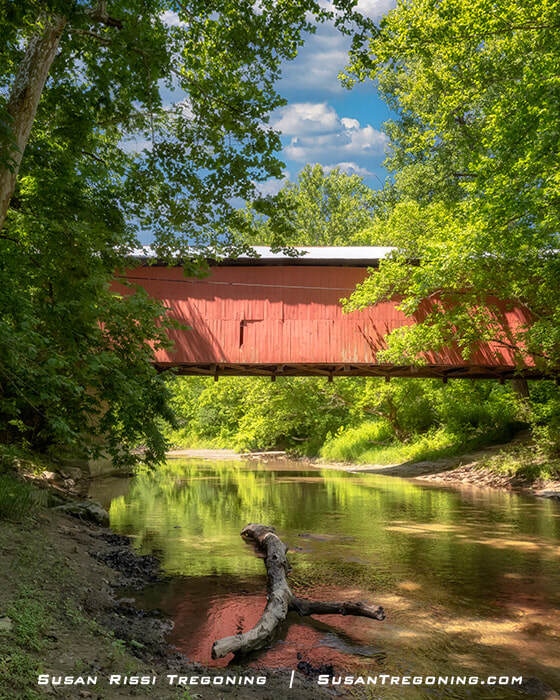
Wilkins Mill Covered Bridge spanning Sugar Mill Creek, the red wooden span reflected in the quiet water and framed by lush summer greenery.
#36 Cox Ford Covered Bridge
Cox Ford Road
N 39.885348 W 087.225881
Autumn at Cox Ford Covered Bridge in Parke County, Indiana, the 1913 white‑entrance span framed by golden foliage along its quiet gravel approach.
J. A. Britton built the single-span Burr Arch truss Cox Ford Covered Bridge in 1913 to replace an iron bridge dating from 1896 that was lost in the Great Flood of 1913. The bridge spans 106 feet across Sugar Creek.
When Cox Ford was first bridged in 1896, J.J. Daniels and J.A. Britton both submitted bids that came in under the cost of an iron bridge, but the Parke County Commissioners decided to use an iron bridge since it was considered more modern at the time.
When bidding to replace that iron bridge, Britton's bid raised the new bridge five feet to prevent future flooding. It was also contingent on reusing the old iron bridge abutments and the Burr Arch trusses from Henry Wolfe’s 1854 Armiesburg Covered Bridge which was also destroyed by the flood that year along with the Plank Road and Hargrave Covered Bridges.
This saved time and money for Parke County, which needed multiple bridges rebuilt because of the flood. Britton was allowed to build two other bridges that year: the Howard Bridge on Plank Road, which was torn down during the expansion of US-36 around 1932, and the State Sanatorium Bridge. The Armiesburg Bridge was replaced with a concrete one.
A scenic autumn view of Sugar Creek, where golden foliage reflects in the calm water beneath an arching riverside tree.
It may have also saved a piece of Britton’s family history. It is thought that Charlton Britton, J.A. Britton’s father, and Julius Egbert may have cut these arches with a whipsaw while Wolfe was building the Armiesburg Bridge. That whipsaw was later given to J.A. Britton by his father.
Today, the bridge still has the unique distinction of having arches that are 59 years older than the bridge itself. But, the original hand-hewn stone abutments, weathered through the years, needed additional support. As a result, they can no longer be seen and are encased in five feet of poured concrete.
Fall colors reflect on Sugar Creek beneath the red Cox Ford Covered Bridge, with golden foliage mirrored in the calm water and the wooden span framed by autumn trees.
This is a popular spot for kayaking, canoeing, and inner tubing on the western edge of Turkey Run State Park. It has a large parking lot and a stairway for easy access to the water.
Please be careful near the road during the summer months. Bus traffic is almost constant here since the water sports rental companies use the parking lots as drop-off points. Also, since the bridge was raised five feet to protect it from flooding, it is now higher than the road, making visibility poor for drivers and pedestrians.
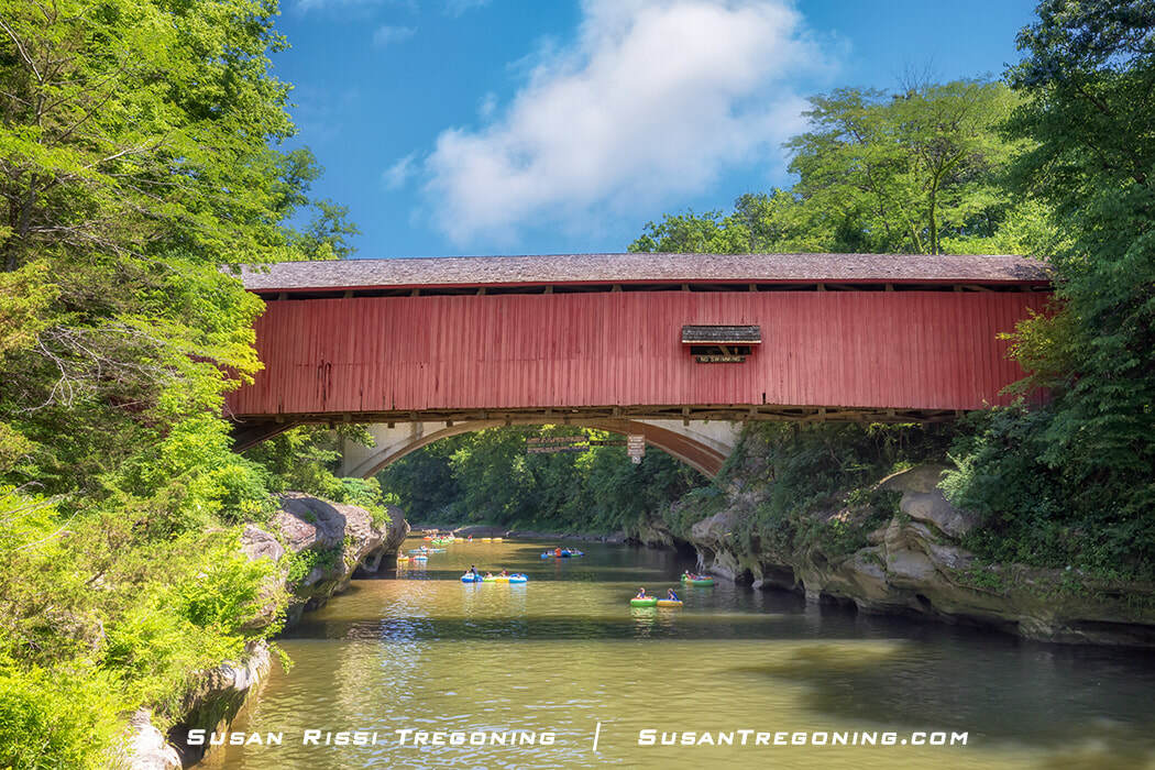
#37 Narrows Covered Bridge
Narrows Road
N 39.890720 W 087.187867
Autumn at the Narrows Covered Bridge in Turkey Run State Park.
Located on the edge of Turkey Run State Park, the Narrows Covered Bridge is widely considered the most scenic spot in Parke County and, because of that, the most photographed covered bridge in the state. Sugar Creek is also a popular tubing and canoe area during summer. Most people get dropped off at the Cox Ford Covered Bridge on the opposite side of the park and float down to the Narrows.
Constructed in 1883 by J. A. Britton, Narrows Covered Bridge spans 121 feet across Sugar Creek. It was Britton’s very first covered bridge. This is not to be confused with Britton’s first bridge, which he built in 1880 across Billie Creek, which is considered an open bridge. Something that should be noted on this covered bridge is the pointed arch. Called out by the covered bridge purest, the perfectly ached Burr Arch Truss is something Britton did not perfect until around the 1900s. Narrows Bridge was bypassed in 1960 and rebuilt in 1977.
On a personal note, J.A. Britton’s first wife died during the construction of the Narrows Covered Bridge. He met his second wife, who lived on a nearby farm before the bridge was completed.
While the creek is known as Sugar Creek today, the Pottawatomie Indians once called the area Pungosecone, which can be translated to “the waters of many sugar trees. " Because of the large rocks here, the water through the Narrows was Rock River.
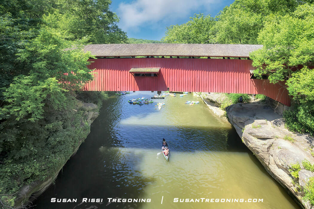
People enjoy the warm summertime weather, floating down Sugar Creek and under the Narrows Covered Bridge in inner tubes and canoes.
Britton’s Narrows Covered Bridge was built to replace the covered bridge that Salmon Lusk constructed next to his mill...
Captain Salmon Lusk (1788-1869) served under William Henry Harrison in the Battle of Tippecanoe during the War of 1812.
In 1825, he was awarded a government land grant for his service. This property would eventually become the first parcel of land acquired for Turkey Run State Park, Indiana’s second-oldest state park.
As one of the first settlers to the area, Lusk came from Vermont and was largely self-sufficient. He first built a log cabin for his wife and eight children. The Lusk Family lived there until 1841 when they moved into the brick house he and his sons constructed out of bricks they made themselves. He also dug a coal mine to heat his home, which is still there today, and is now a bat habitat.
In 1829, Lusk built a gristmill, and a settlement grew around the Lusk’s home and mill. Lusk constructed the first bridge across Sugar Creek next to his mill in 1840. Unfortunately, that bridge was destroyed in the New Year’s Day flood in 1847. The flooding was so severe that every building in the settlement was lost except for Lusk’s brick home. Lusk replaced the bridge that same year, and it stood until 1875 when it was also destroyed.
Salmon Lusk died in 1869, and his widow and son, John, continued to live in the family home. After John’s mother passed in 1880, he inherited the property. Said to be eccentric, John is quoted as having expressed his love of “every rock, hill, hollow, bush, and tree,” preventing him from selling the rights to loggers. However, he allowed visitors to enjoy the land he loved while still alive.
After John passed in 1915, the property was put up for sale. The State Parks Commission wanted the property, but before they could raise funds, it was purchased by a logging company. Then, after last-minute support from the Indianapolis Motor Speedway, they bought it from the lumber company in 1916 for substantially more money than the lumber mill initially paid, thus saving the property from woodcutting.
The restored Lusk Home still stands today and is open during the summer for tours. After paying an entrance fee at the Turkey Run main gate, you may hike or drive to the Lusk Home to visit. For more information about tours, call the park office.
Narrows Covered Bridge, widely considered the most scenic spot in Parke County, with kayakers and tubers drifting down Sugar Creek beneath the red wooden span on a warm summer day.
Billie Creek Village
65 Billie Creek Road, Rockville
Billie Creek Village is a scenic 70-acre living history museum that displays over 35 of Parke County's historic buildings, from an 1830s log cabin to a 1913 schoolhouse. In addition, three of Parke County's 31 covered bridges are located here.
You can walk the grounds daily from dawn to dusk at no cost to visit. However, during the Covered Bridge Festival, parking is charged. The buildings are only open during special events or by appointment for a very reasonable fee.
Visit the Billie Creek Village website for more information about the village and upcoming events.
# 38 Beeson Covered Bridge
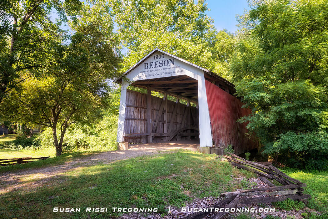
Beeson Covered Bridge, the 1906 white‑front, red‑sided span set among the trees at Billie Creek Village.
Beeson Covered Bridge, which spans 55' across Williams Creek, now resides at Billie Creek Village. It was built in 1906 by the Frankfort Construction Company and was once located very close to the town of Marshall.
Since the Beeson Bridge was moved to Billie Creek Village in 1980, the Marshall Arch, located in the center of Marshall, is the town's only remaining historical feature.
The Beeson Covered Bridge originally spanned Roaring Creek on an important route between Marshall, the Turkey Run High School, and Turkey Run State Park. After the abutments were deemed unsafe in 1969, the bridge was closed, and it sat in disrepair until a concrete bridge on the detour route collapsed in 1979, completely blocking access to the town from the Turkey Run area. The town knew something needed to be done, but it took two arson attempts, only a week apart in August of 1979, to force a decision to save the covered bridge by moving it. Finally, Beeson Bridge was moved to the entrance of Billie Creek Village as a footbridge, making way for a new bridge to be built in Marshall.
The Beeson Covered Bridge was named for William H. Beeson, whose family owned 53 acres of land near the bridge for over one hundred years.
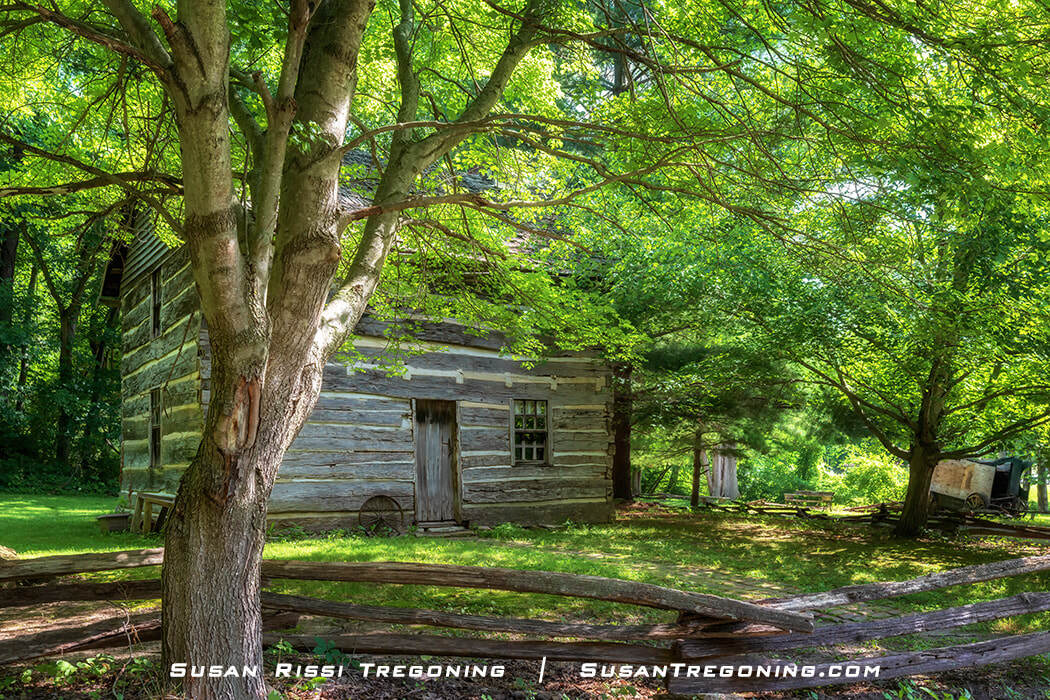
The lush summer foliage almost hides the historic Beeson family log cabin, its weathered logs tucked into the greenery at Billie Creek Village.
The Beeson Family’s log cabin, dating to 1835, is also at Billie Creek Village. It was moved to the Village in 1969 to be preserved and is located just down the path from Beeson Bridge on the right.
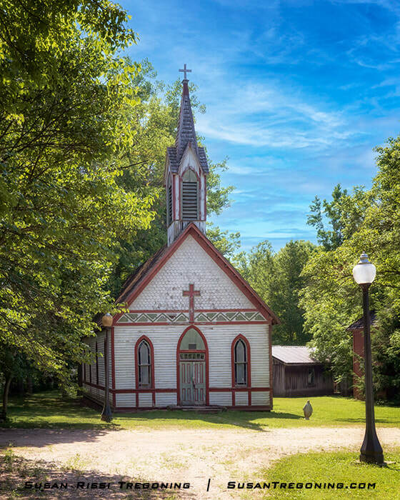
1886 St. Joseph's Catholic Church.
The St. Joseph's Catholic Church was built in Rockville in 1886 and served the community for 85 years. When the parish decided to build a new church in the same location, the old one was donated to Billie Creek Village.
The Billie Creek General Store, circa 1850-1860, was moved to the village from Annapolis. The town was once a thriving Quaker community but began to decline after the B&O Railroad decided to go through Bloomingdale instead.
It was first moved to Bloomingdale before moving to Billie Creek in 1968.
Located in the heart of the village, Billie Creek continues to use the store as intended, so while the building’s exterior is original, the interior is not.
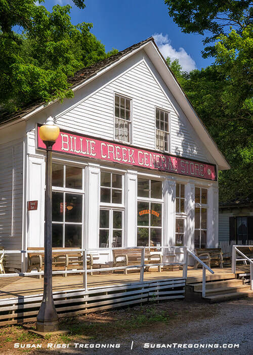
Billie Creek General Store
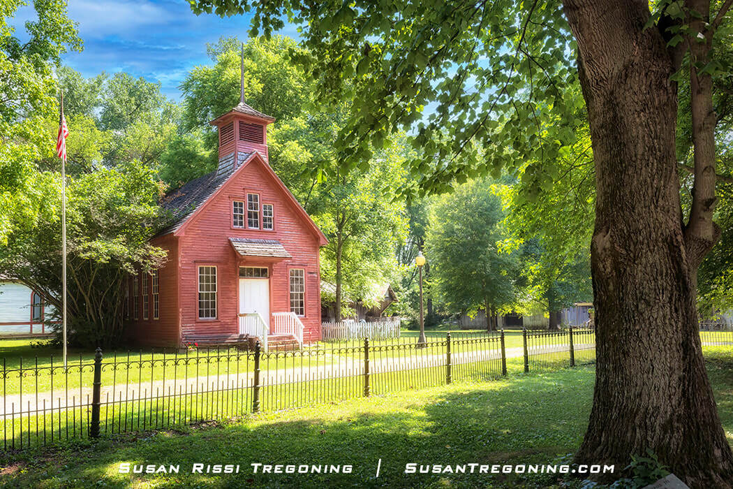
Huxford Schoolhouse
Dating to 1923, the Huxford Schoolhouse is one of the last one-room schoolhouses left in Parke County. It’s a typical rural school where a single teacher would have taught grades 1 through 8. Classes would have been held from September to late March.
The Hyxford School was used for 15 years. After the local schools had consolidated, it became a storage building at Huxford Farm.
Billie Creek Village initially approached the Huxford family about purchasing the building but was refused. Finally, in 1968, the Huxfords offered to donate the schoolhouse as long as the village paid for its relocation.
#39 Billie Creek Covered Bridge
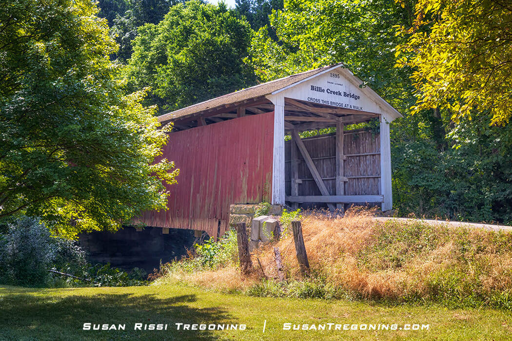
Billie Creek Covered Bridge
The Billie Creek Covered Bridge, built in 1895, stretches 62 feet across Williams Creek at Billie Creek Village. Locals have long used the creek’s nickname, “Billie Creek,” and both the bridge and the village adopted that familiar name. This span replaced J.A. Britton’s 1880 open bridge—his first bridge project—which deteriorated quickly without the protection of a cover.
Construction of the new bridge brought together several well‑known Parke County builders. The Van Fossen brothers were responsible for at least four of the county’s covered bridges, and possibly more, and three of their structures still stand today. For the Billie Creek and Roseville Covered Bridges, they relied on the expertise of master builder J.J. Daniels. At Billie Creek, J.P. Van Fossen served as the contractor, while Daniels worked on site as the foreman. The sandstone abutments were handled separately by J.L. Van Fossen, who sourced the stone from A.E. Fuel’s quarry less than a mile away. When first completed, the bridge featured Daniels’ distinctive arched portals, though the portals have since been altered.
The bridge sits along what is now known as Old US 36, but its transportation story stretches back much further. Around 1850, this route was Plank Road, a toll road built of wooden planks between Rockville and Bellmore. The road eventually extended from the Wabash River all the way to Indianapolis. When the planks inevitably rotted, they were removed and the road was graveled. Parke County purchased its section sometime around 1867 or 1877, converting it into a free public road.
By the time the covered bridge was built, the route was likely still called Plank Road, but it soon became part of the Pikes Peak Ocean to Ocean Highway—a coast‑to‑coast route stretching from New York City to Los Angeles. That highway later evolved into US‑36. When the modern highway was expanded, the section around the bridge was bypassed, sparing the old span from heavy traffic and ensuring its survival. Without that bypass, this beautifully preserved covered bridge might not be standing today.
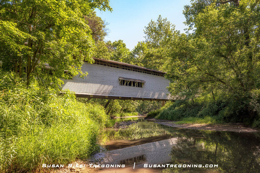
#25 Leatherwood Station Covered Bridge
I knew Leatherwood Station Covered Bridge was at Billie Creek Village, but I never did find it. My GPS coordinates led me to the driveway next to the Billie Creek Covered Bridge that is marked "Private Property." I only found this Billie Creek Property Map after I visited.
J.A. Britton built the Leatherwood Station Covered Bridge in 1899. Initially, 72 feet across Leatherwood Creek, it was named for the creek and the Leatherwood Train Station. It was also known as Henry Wolf Covered Bridge after the local landowner.
The bridge initially sat on sandstone abutments and had angular Britton Portals. The framework can still be seen for those original Britton Portals inside the bridge, but they were eventually converted to Daniel’s Arch.
The bridge was moved to Billie Creek Village in 1981 and now spans Williams Creek, which is sitting on new concrete with sandstone showing abutments. The bridge is now an attraction used mainly for foot traffic and the occasional horse and wagon.
Not every image makes it into my blog. If you enjoyed the images in this article, here are a couple of my travel image collections that might interest you...
To see more locations in the great state of Indiana, visit the Indiana Collection. If you are a lover of all types of bridges and want to see more bridges around the United States, here is the Bridge Collection. For all things Country, such as, barns, mills, and more covered bridges from around the US, check out my Country Living Collection.

The Narrows Covered Bridge stands over Sugar Creek in full autumn color, a classic Parke County landmark framed by vibrant foliage and quiet water.
Fine Art Prints are available for order as print only, framed art, canvas art, metal art, acrylic art, and wood art prints in various sizes. Home Decor and Gift Ideas include shower curtains, throw pillows, towels, totes, phone cases, t-shirts, puzzles, blankets, and more. Worldwide Shipping with a 30-day money-back guarantee.
More of the USA
- A Travelers Musings (1)
- Alabama (1)
- Hawaii (3)
- Illinois (6)
- Indiana (3)
- Iowa (3)
- Louisiana (1)
- Maryland (1)
- Michigan (2)
- Minnesota (4)
- Mississippi (6)
- Missouri (2)
- Montana (1)
- Nebraska (5)
- New Mexico (1)
- North Carolina (1)
- Pennsylvania (2)
- Route 66 (5)
- South Dakota (1)
- Tennessee (1)
- Texas (1)
- Virginia (2)
- Washington DC (1)
- West Virginia (3)
- Wildlife (6)
- Wisconsin (2)
- Wyoming (4)
