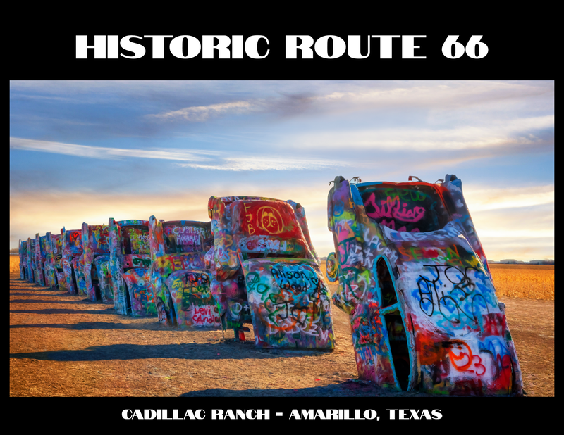
The Best of New Mexico Route 66

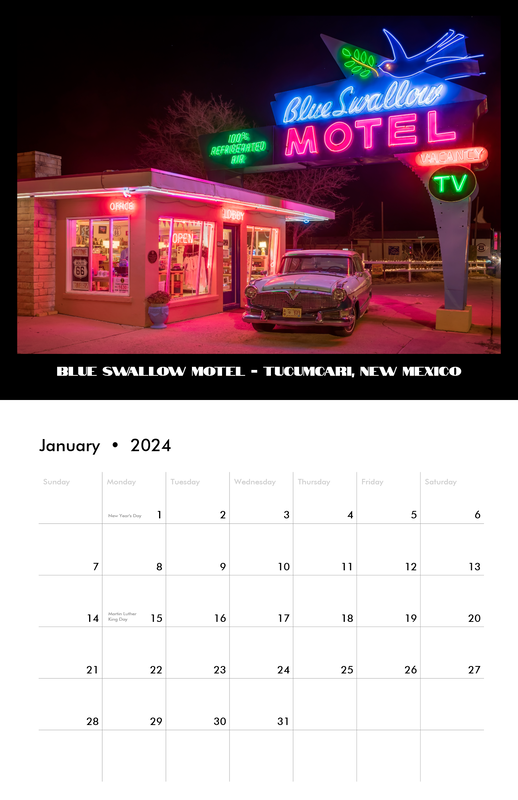
The Blue Swallow Motel’s classic neon sign and preserved motor‑court architecture capture the enduring charm of Tucumcari’s Route 66 heritage.
Get your kicks on New Mexico's Route 66 National Scenic Byway!
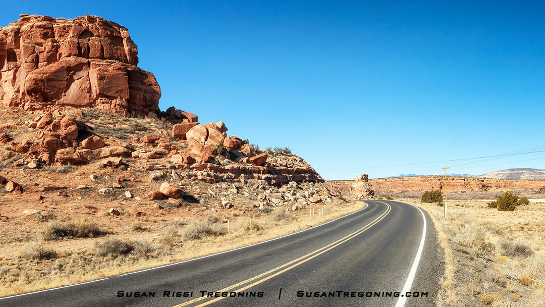
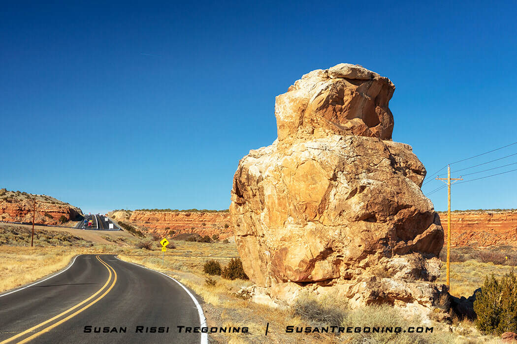
New Mexico has one of the most varied landscapes in the United States, and Route 66 crosses all its land regions. Enter New Mexico in the Great Plains at the ghost town of Glenrio, where the landscape is flat and grassy. As you reach Tucumcari, the land begins transitioning to the high desert with broad valleys, deep canyons, sharp cliffs, and flat-topped mesas. It is both harsh and majestic. Nearing the middle of the state, you’ll wind through the mountain pass of Tijeras Canyon as you work your way to Albuquerque in the valley below. Nine Mile Hill brings you up from the valley toward El Malpais, the stark lava landscape near Grants. Approaching the Continental Divide, the lava gives way to breathtaking red-hued cliffs. Those beautiful red cliffs keep getting better and better as you pass through Gallup shortly before exiting the state.
Along New Mexico's section of the Mother Road, you will experience the charm of adobe villages in a land heavily steeped in Spanish and Native American culture alongside an eccentric collection of roadside architecture ranging from motels, 50s diners, gas stations, and colorful neon. Discover why New Mexico is known as the “Land of Enchantment.”
A Brief History of the Mother Road
Route 66 spans eight states-- Illinois, Missouri, Kansas, Oklahoma, Texas, New Mexico, Arizona, and California—for 2,448 miles, passing through the heartland of America and the desert Southwest.
Born in 1926, as automobile transportation grew in popularity, there was an increasing demand for an all-weather, year-round route to the West. Route 66 was created by combining preexisting roads, trails, and popular motoring routes. It ended up winding its way right through the center of every town along the way, earning it the nickname Main Street of America.
In its early years, it enabled the Dust Bowl emigrants to flee West for a better life, aided World War II military mobilization, and fed the boom for post-war tourism. It became the symbol of mobility, freedom, and the pursuit of the American Dream, linking small rural towns to urban centers from Chicago, Illinois, to Santa Monica, California.
The first alignment of the road, dating from 1926 to 1938, was dirt; it was narrow and twisty and impossible to drive after inclement weather, but the people kept coming in droves, and soon, they began improving the roadway. By 1938, almost the entire drive was concrete or asphalt. In addition, some of the road sections had been widened and curves straightened. Several changes in the alignment soon followed, shortening and perfecting the route along the way.
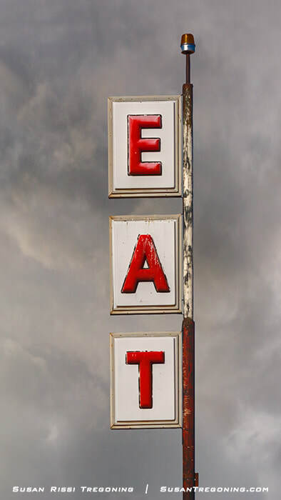
The famous vertical EAT sign in San Jon, New Mexico, a weathered Route 66 landmark that once pointed travelers toward a classic roadside café.
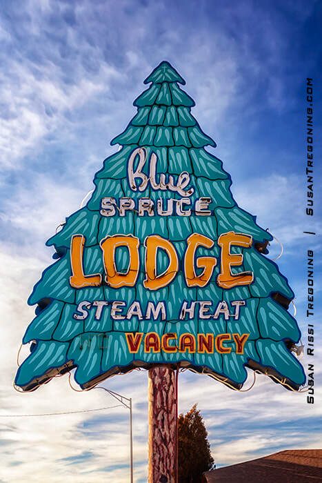
The Blue Spruce Lodge neon sign in Gallup, a classic mid‑century Route 66 landmark shaped like a stylized spruce tree and glowing with vintage roadside character.
John Steinbeck is responsible for nicknaming it the Mother Road. A chapter in his 1939 Pulitzer Prize-winning novel The Grapes of Wrath, about 1930s Dust Bowl migrants, is titled "Mother Road."
No other road has been as celebrated through movies, books, and music as Route 66. It has become synonymous with the spirit of adventure and the symbol of hope and progress more than any other highway.
Moreover, it facilitated one of the most comprehensive movements of people in U.S. history, transforming the "Wild West" frontier into a fast-paced metropolitan area. As a result, every tiny burg and rural town along Route 66 saw an economic boom as it twisted and turned past hundreds of cafes, motels, gas stations, and tourist attractions.
Sadly, the nation's first highway was a victim of its own success, with the popularity of travel and the need for speed for military use and commercial transportation trucking supplies Westward. The 1950s saw the arrival of the Interstate System, which bypassed the towns, allowing travelers to go farther faster. Nevertheless, most of small-town America was able to hang on through the 1960s.
Still, as the Interstates were completed and grew in popularity, traffic was no longer there to support the many businesses along the Mother Road. By the 1970s, the Mom and Pop establishments were almost completely gone, leaving empty storefronts and desolate towns ravaged by the lack of traffic.
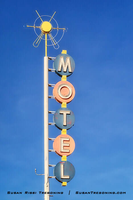
A playful mid‑century motel sign in Albuquerque, its stacked blue and pink circles adding a burst of color along Route 66.
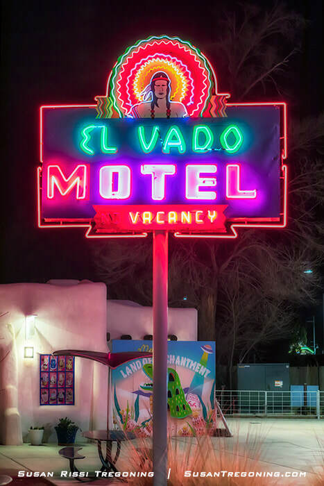
A vivid neon landmark along Albuquerque’s stretch of Route 66, the El Vado Motel sign blends mid‑century design with the city’s Southwestern identity.
As people began moving away looking for jobs, populations dwindled, leaving ghost towns in their wake. By 1985, Route 66 was decommissioned, stricken from the maps, and the signage removed.
Today, over 85% of the original Route 66 alignments are still drivable, and the Mother Road is resurging in popularity. Thanks to various public and private organizations that understand its historical and social significance, efforts are now being made to preserve and commemorate the highway. In addition, important historic features are being nominated and listed on the National Register of Historic Places to save them.
With Route 66s resurgence in popularity, all eight states have marked it again and designated the drive as a State or National Scenic Byway. So it's an exciting time along the Mother Road again!
New Mexico 66
New Mexico has two alignments of Route 66 totaling almost 500 miles.
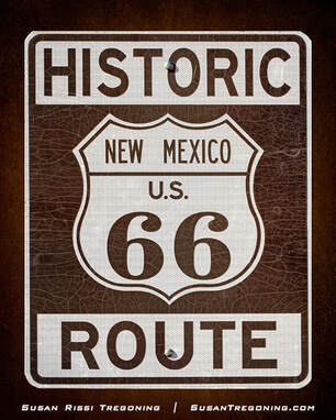
A classic Historic Route 66 road sign marking the New Mexico stretch of the Mother Road, echoing the state’s deep ties to America’s most famous highway.
The current alignment, the route driven after 1937, is about 400 miles long. It runs in a straight line parallel to Interstate 40 and has become I-40 in areas where 66 no longer remains. It is the most common Route 66 alignment driven today.
The Santa Fe Loop - New Mexico's Original Alignment
When New Mexico's section of Route 66 was routed in 1926, it followed the Old Pecos Trail from Santa Rosa to Santa Fe before dipping south to Albuquerque.
That same year, New Mexico's then-governor, Arthur Thomas Hannett, lost his reelection bid. Peeved at Santa Fe's political climate, Hannett set in motion a plan that his political rivals were vehemently against that would eventually become known as "Hannett's Joke." With only one month left in office, Hannett decided to complete the 69-mile missing road link between Santa Rosa and Albuquerque.
Before becoming governor, Hannett had been highway commissioner and commanded much respect and loyalty within the Highway Department for significantly expanding New Mexico's highway system. Using road crews only loyal to him, he placed one crew north of Santa Rosa and another near Moriarty. Hannett's men worked long hours despite sabotage, bitter cold, and snow, even giving up their Christmas holiday. The two crews would meet in the middle when they finished the road.
Finally, Inauguration Day arrived on January 1, 1927, and the road was just shy of completion. The new governor attempted to halt the roadwork, but a brutal January storm delayed his engineer, and the road was completed. This new road became New Mexico 6. "Hannett's Joke" shaved more than 100 miles off the drive by bypassing Santa Fe entirely. It officially became part of Route 66 in 1937.
Today, the original section of Route 66, only used between 1926 and 1937, is now known as the Santa Fe Loop. Much of it runs parallel to Interstate 25. Outside of Santa Fe and Albuquerque, very few Pre-1937 Route 66 features still exist. Some sections of the roadway are entirely missing, have been integrated into I-25, or are now on private property. Most of what remains are tiny villages with small churches, Pecos National Historical Park, and Pueblos.
While I consider the Santa Fe Loop worth driving, I recommend exploring the current Route 66 alignment first.
The Best of New Mexico Route 66
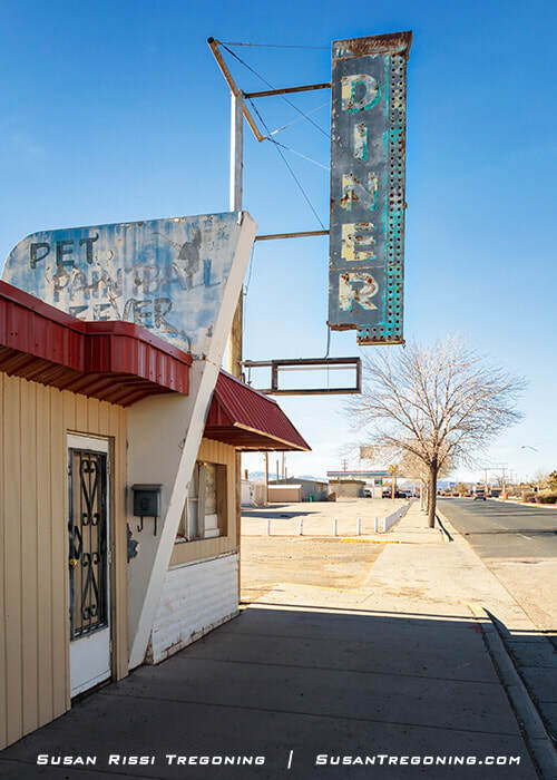
Tucumcari
Tucumcari is my favorite town along New Mexico Route 66. Be sure to drive the entire town—it's one of the best.
Route 66 is also known as Tucumcari Boulevard. The two street names are used interchangeably, which caused me quite a bit of confusion when planning my visit. While there, my GPS didn't always recognize a Route 66 address. Changing the street name to Tucumcari Boulevard would sometimes work, and if the address is already Tucumcari Boulevard, try Route 66.
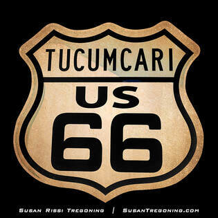
A weathered Tucumcari, New Mexico, Route 66 shield celebrating one of the most iconic stretches of the Mother Road.
The dividing line between East Tucumcari/E Route 66 Blvd and West Tucumcari/W Route 66 Blvd is 1st Street, which is easy to find. La Cita sits on the corner of 1st and Route 66. That's the giant Sombrero hat building.
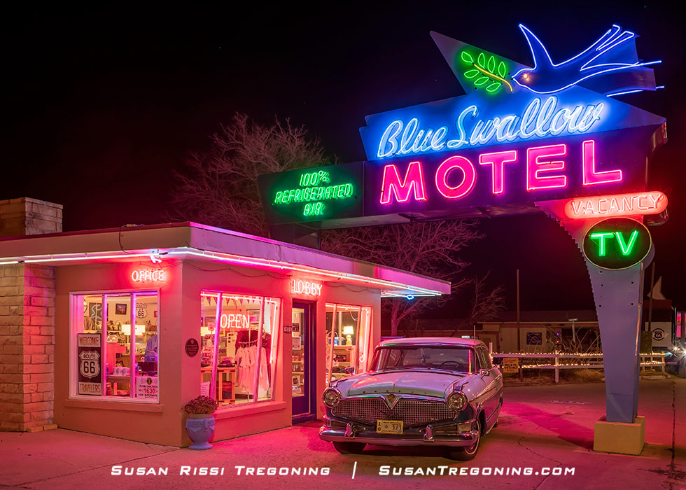
Blue Swallow Motel
815 E Route 66 Blvd
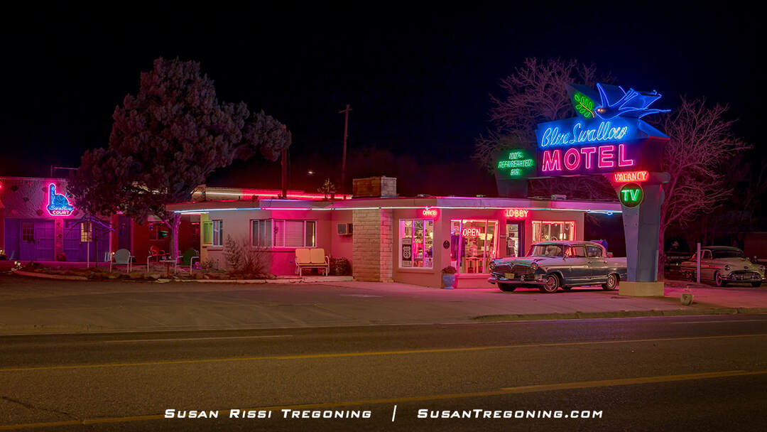
A fully lit nighttime view of the Blue Swallow Motel in Tucumcari, New Mexico, showcasing one of Route 66’s most celebrated neon landmarks.
The famed Blue Swallow Motel is a True Gem on Route 66 and is widely considered one of the BEST Route 66 Motels. The Blue Swallow is one of the longest continuously operated motels along the New Mexico stretch of the Mother Road. Smithsonian Magazine has named it "the last, best, and friendliest of the old-time motels."
Originally named the Blue Swallow Court when it opened in 1942, this historic motor court, with its distinctive attached garages between the rooms, also had a café on site.
The original owners died in a plane crash in the 1950s. The second owner installed the beautiful large neon sign and modernized the name by changing it from the Blue Swallow Court to the Blue Swallow Motel.
The Blue Swallow was added to the National Register of Historic Places in 1993, qualifying under the transportation and architecture criteria.
Designed in the Southwest Vernacular architectural style, the Blue Swallow Motel is one of the best examples of a largely unaltered pre-war tourist court remaining along Route 66.
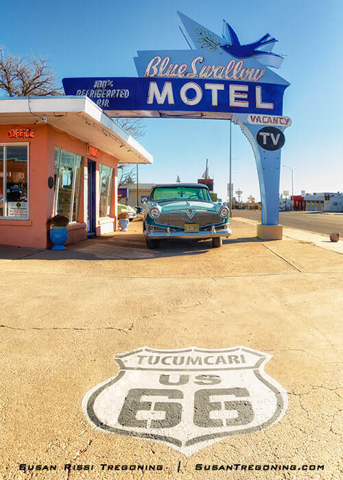
A Route 66 essential: the Blue Swallow Motel’s vibrant neon sign rising above its vintage courtyard and classic car, capturing the spirit of Tucumcari. I consider the Blue Swallow's neon sign the absolute BEST on Route 66 and a MUST SEE at night.
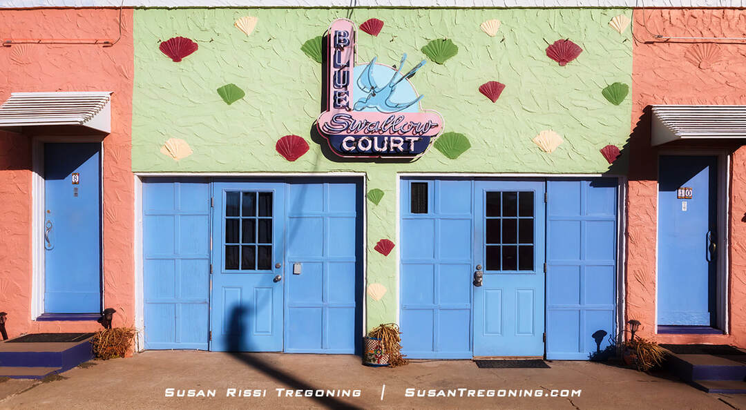
A rare look at the original 1942 Blue Swallow Court neon sign, now mounted between the garage doors behind the motel and still echoing its early Route 66 roots.
Since the late 1990s, the Blue Swallow has undergone extensive restoration to maintain its historic charm and character while providing the modern conveniences that today's travelers require.
If you only plan to stay at one of the Historic Route 66 Hotels, the Blue Swallow is a must! Check out the Blue Swallow website for more information. You can check room availability rates and book online from there.
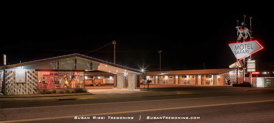
Motel Safari
722 E Route 66 Blvd
A nighttime view of the Motel Safari, its camel‑and‑rider neon sign and vintage motor‑court design lighting up Route 66 in Tucumcari.
Back in the day, the Hotel Safari, which opened in 1959 at the height of the Mother Road's popularity, was one of the most popular and modern motels on the Tucumcari Route 66 strip.
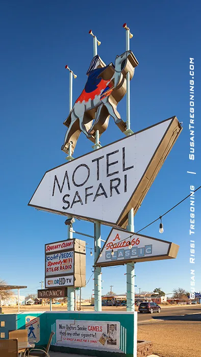
The Motel Safari was constructed by an independent motel developer in the Googie architectural style, eventually becoming Mid-Century Modern. This futuristic architecture, influenced by car culture, jets, the Space Age, and the Atomic Age, was famous nationwide from 1945 to the early 1970s. So many of the distinctive futuristic design elements are still visible. You will find the fun geometric neon sign topped with Clyde the Camel, oozing brick mortar and counter-stacked bricks, square holes in the cinder block structures, and perforations in metal cylinders that glow like stars at night.
An extensive renovation began on the Hotel Safari in 2007. Much of the original custom mid-century modern furniture has been saved and restored, with newer pieces carefully selected to complement the decor. In addition, modern amenities have been added without sacrificing the motel's historic appearance.
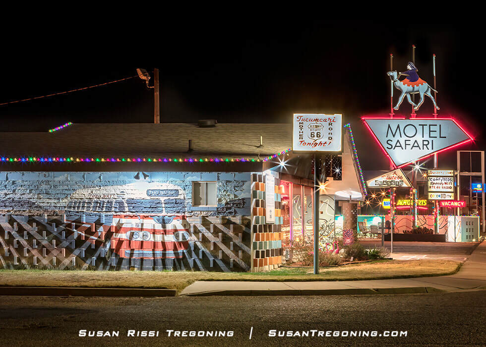
A 1950s Santa Fe Trailways Flexible Clipper tour bus with 'Tucumcari Tonite' as its destination is one of the murals featured on the back of the Motel Safari.
The Motel Safari is one of the premier vintage motels along Historic Route 66. This retro motel is one cool place to stay!
Check out the Motel Safari website for more information. You can make your reservation online from there.
Tee Pee Curios
924 E Route 66 Blvd
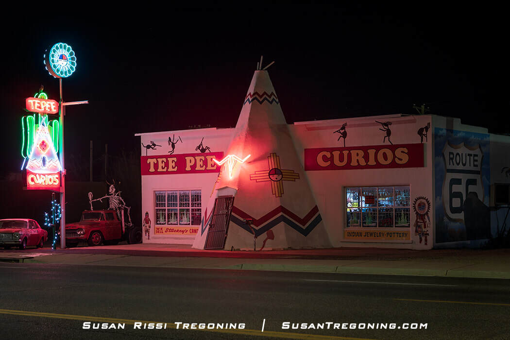
One of New Mexico’s last original curio shops, Tee Pee Curios in Tucumcari glows in full neon, standing as a true Historic Route 66 icon.
Tee Pee Curios is a magical and quirky piece of roadside architecture. I must confess that it gave me a thrill to walk through that teepee door when I visited the store during the day. However, this place also deserves a nighttime visit to appreciate its magnificent vintage neon.
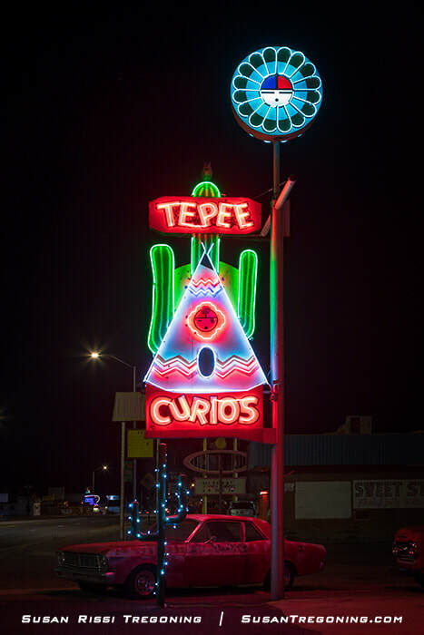
A mid‑1960s neon addition, the Tepee Curios sign lights up the Tucumcari night—an unmistakable beacon along the Mother Road.
One of New Mexico's last original curio shops along the Mother Road, this is a MUST-VISIT Historic Route 66 icon.
It opened in 1944 as a Gulf service station, grocery store, and souvenir shop. When Route 66 was widened from two lanes to four in 1959, the gas pumps were removed, and the teepee entrance was added to the front of the building.
The whimsical neon sign was added in the mid-1960s. It is one of the best neon signs along Route 66. The sign was one of nine restored during the 2003 New Mexico Route 66 Neon Sign Restoration Project. The neon longhorn skull on the front of the teepee was added at about the same time as the restoration.
Did you notice the different spelling of Tee Pee on the sign? Is it a mistake or intentional? No one seems to know. Please note me in the comments below if you discover the answer.
La Cita
821 S 1st Street (Intersection of Route 66 & 1st Street)
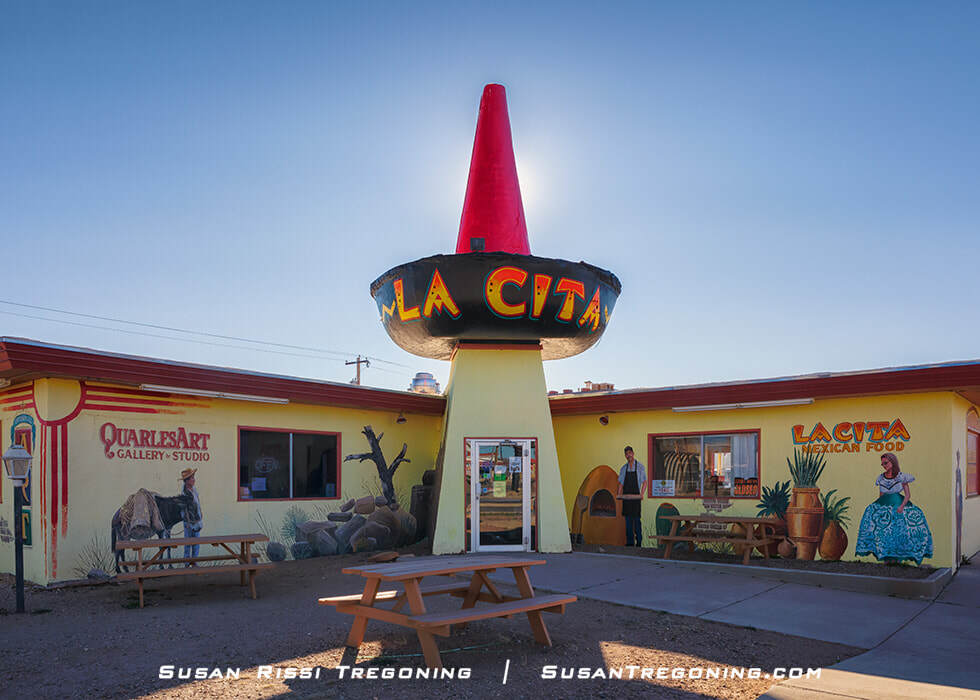
La Cita’s giant sombrero rises over Tucumcari’s stretch of Route 66, a vibrant reminder of the Mother Road’s quirky roadside architecture.
La Cita was made famous with a rave review by Duncan Hines. Before Duncan Hines signed over his name for use on boxed cake mixes, he was well known as the first food and travel critic who rated restaurants and motels for travelers. Duncan Hines wrote the book Adventures in Good Eating, a travel food guide he updated and reprinted annually from 1936 to 1944.
The La Cita restaurant opened in 1944 on the north side of Route 66, across the street from where it is today. In 1961, the restaurant moved to its current location, taking the distinctive neon sombrero sign with it. The giant sombrero hat over the door was added to the building sometime later.
La Cita's neon sign was one of the nine neon signs restored during the 2003 New Mexico Route 66 Neon Sign Restoration Project. The building was repainted after the sign's restoration, and these beautiful murals were added.
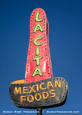
La Cita’s 1944 neon sombrero rises against the New Mexico sky, a classic piece of Tucumcari’s Route 66 roadside history.
Tucumcari's West Route 66
Overall, the west end of Route 66 in Tucumcari is a little rougher around the edges. Fewer buildings still have businesses in them, and more open spaces where buildings have been razed. This is not a complaint. Tucumcari has done an excellent job of cleaning up the derelict, falling-down buildings, which isn't always the case along Route 66.
Route 66 Museum & Convention Center
1500 W Route 66
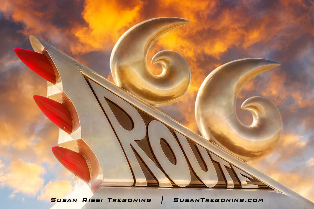
A chrome 1950s tailfin sculpture with bullet lights and a pair of stylized sixes forms the very top of the Route 66 monument.
Artist Tom Coffin created and dedicated this tribute to the Mother Road in 1997. It is located in front of the Tucumcari Convention Center, right on Route 66.
The museum is behind the Convention Center.
Ranch House Cafe
1015 W Route 66 Blvd
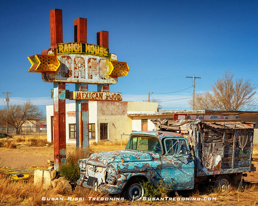
In one of the grittier locations in Tucumcari, a dilapidated Chevy truck sits abandoned beside the old rusted neon sign of the Ranch House Café.
This café opened in 1952 with the slogan “Good Food Always—Always Good Food.” The building has interesting triangular windows on the side and a triangular-shaped column on the front that, at one time, was a second sign for the restaurant.
The old neon sign on the ground says, “Things." It’s from Things Antiques & Collectibles, which was once located in the 900 block of West Route 66.
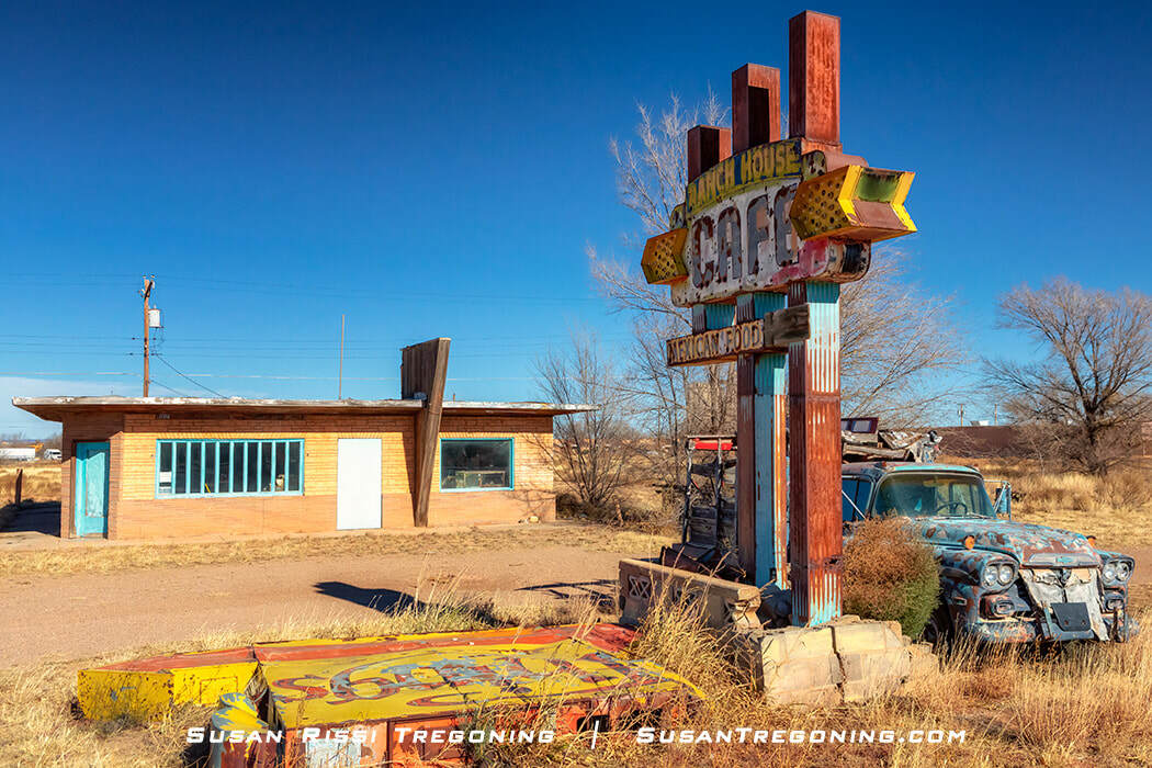
The closed Ranch House Café in Tucumcari, New Mexico, has an interesting triangular-shaped column in front of the restaurant. It reminds me of a Valentine's "Double Deluxe" Diner, but I have not found any reference to that in my research.
Wall Murals
Murals are scattered throughout the town. Here's a link to the online Mural Map. You can also pick up a mural map at the Tucumcari Chamber of Commerce Visitor Center at 404 W Route 66. If it is after hours for the Chamber office, check at some of the businesses in town. I found mine at the Route 66 Welcome Center and Gift Shop at 901 E Route 66.
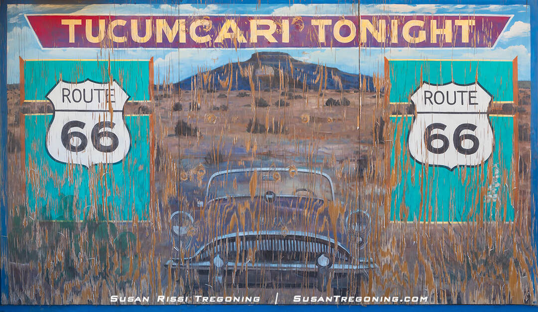
The weathered Tucumcari Tonight mural depicts an old Buick convertible parked in the desert in front of Mesa Tucumcari just outside Tucumcari, New Mexico.
Painted by artists Doug and Sharon Quarles, this weathered Tucumcari Tonight mural depicts an old Buick convertible parked in the desert in front of Mesa Tucumcari just outside town.
During the heyday of Route 66, hundreds of billboards from Chicago to Santa Monica lined Route 66 with the slogan "Tucumcari Tonight," inviting weary travelers to stay in one of their 2000 motel rooms. While that number of rooms later dropped to 1200, less than that now, Tucumcari is still a popular stopping point since it is the largest town between Amarillo and Albuquerque. As a result, "Tucumcari Tonight!" became the most famous slogan along the Mother Road.
Self-Guided Radio Tour
Tucumcari debuted its self-guided radio tour in 2020. It includes 16 sites in town, including a few historical sites not on Route 66. You can pick up the radio signal from about a block away from each location.
Tune your radio to 1640 AM for all the sites except the Blue Swallow Motel. The Blue Swallow can be found at 1630 AM.
Del's Restaurant - 1202 E Route 66 Blvd
Roadrunner Lodge Motel - 1023 E Route 66 Blvd
TeePee Curios - 924 E Route 66 Blvd
Blue Swallow Motel - 815 E Route 66 Blvd
Motel Safari - 722 E Route 66 Blvd
La Cita - 821 S 1st
Desert Inn Motel - 2420 S 1st St
"The Legendary Road" mural at Lowe's Market - 105 W Route 66 Blvd
Tucumcari/Quay County Chamber of Commerce - 404 W Route 66 Blvd.
Pow Wow Restaurant and Lizard Lounge - 801 W Route 66 Blvd.
New Mexico Route 66 Museum - 1500 W Route 66 Blvd
Tucumcari Railroad Museum - 101 E Railroad Ave
Tucumcari Historical Museum - 416 S Adams St
High Street Church - 424 E High St
Odeon Theatre - 123 S Second Street
Quay County Courthouse - 300 S 3rd Street
Santa Rosa
The town was just a large Spanish Rancho named Aqua Negro Chiquita before Don Celso Baco, the city's founder, built a chapel there in 1873, naming it for his mother, Rosa, and Saint Rosa of Lima, the first canonized saint in the New World.
Santa Rosa remained a small community until a transcontinental connection was made here. The Chicago, Rock Island & Pacific Railroad (1901) and El Paso and Northeastern Railway (1902) intersected in town, making it an important transportation hub. It was the largest town in the county just two years later, and the county seat was moved there.
Route 66 arrived in Santa Rosa in 1927. As part of both alignments, Santa Rosa was a welcome and well-known oasis in the desert, with a wide selection of motels, cafes, and service stations lining the highway.
Route 66 Auto Museum
2436 US Route 66
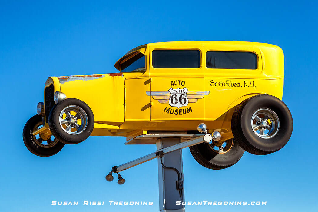
A bright yellow roadster high up on a post is the signage for the Route 66 Auto Museum in Santa Rosa, New Mexico.
The Route 66 Auto Museum in Santa Rosa is owned by James “Bozo” Cordova and his family. Mr. Cordova owns the garage next door and does all the restoration work. More than 30 beautifully restored antique autos are on display, along with motorcycles, bicycles, and other Route 66 memorabilia in the museum.
Sun 'n Sand Motel Neon Sign
2050 US Route 66
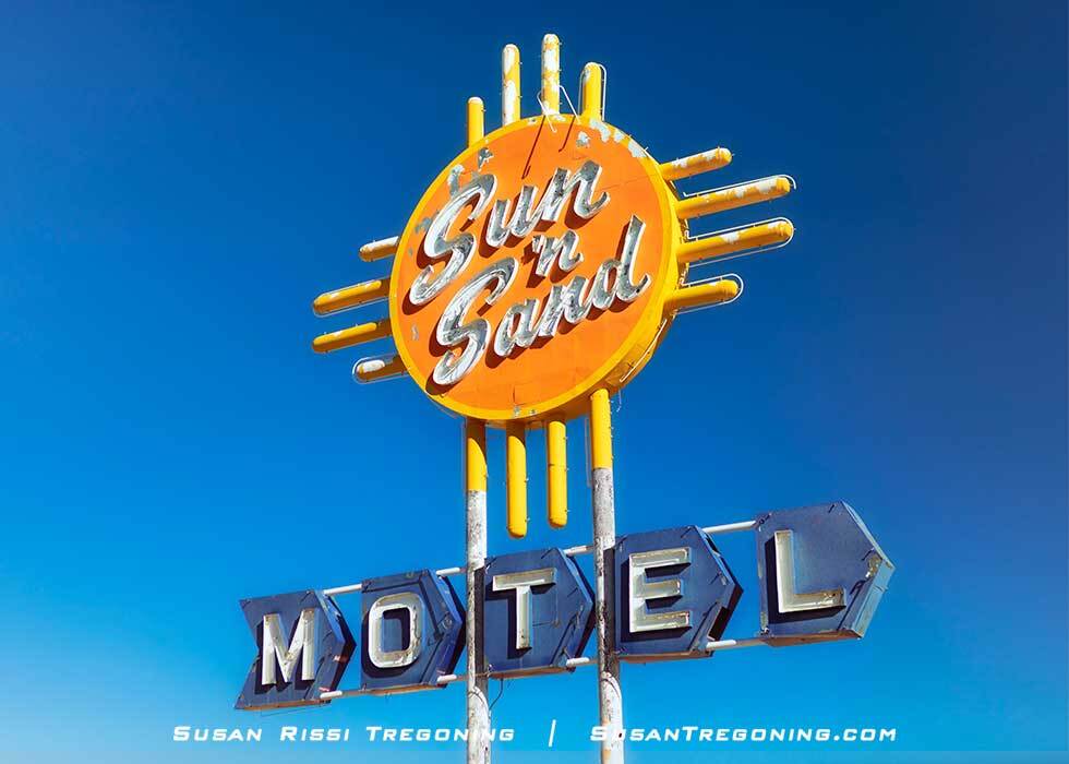
The striking Zia influenced Sun 'n Sand Motel neon sign on Route 66 in Santa Rosa, New Mexico.
The striking Zia-influenced Sun 'n Sand Motel neon sign is considered one of the great New Mexico Route 66 neon signs! Restored during the 2003 New Mexico Route 66 Neon Sign Restoration Project, the blocks that spell out "Motel" were returned to their original blue color. I love how the blocks create an arrow pointing toward the motel.
The motel, which had 40 guest rooms and a restaurant, was built in the mid-to late 1950s. It was remodeled in 1998 but closed again around 2012.
Moriarty
Starting at Moriarty's I-40 Exit 197, there are 57 miles of uninterrupted Route 66 straight through to the west side of Albuquerque.
Sunset Motel
501 US Route 66
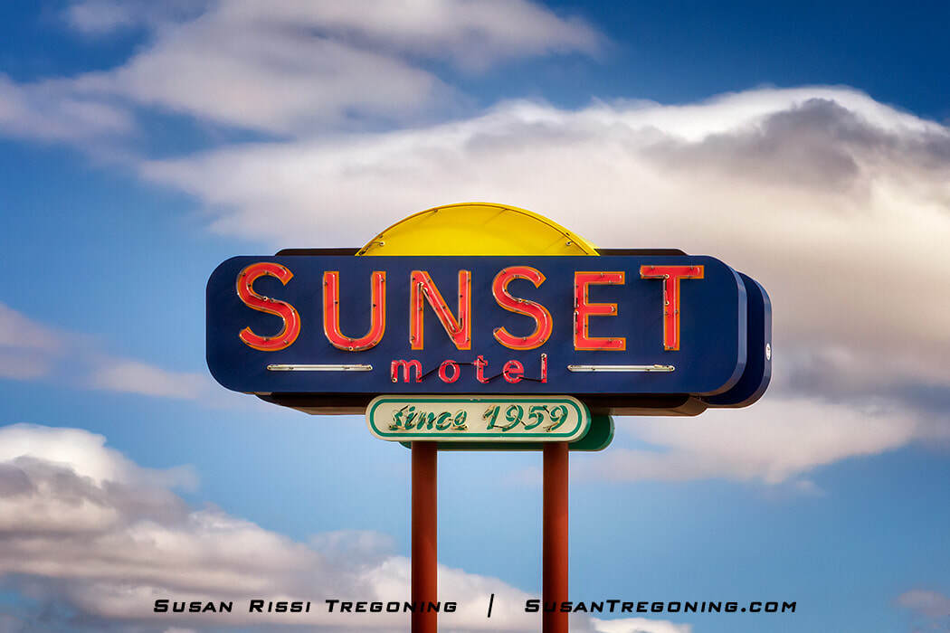
The recently restored Sunset Motel neon sign on Route 66 in Moriarty, New Mexico.
The Sunset Motel is one of the great mom-and-pop motels along Route 66. It is the only original Route 66 motel in New Mexico that is still owned by its original family.
After drawing the initial plans on a brown paper bag, Bill, Elaine Pogue, and their two sons did most of the construction on this Mid-Century Modern motel. Opening in 1959, they operated as a two-room motel without a sign for the first year and then added additional rooms in phases as they could afford to do it. The original plan was to complete a U-shaped motel like those typically seen along Route 66, but Bill passed away before it could be completed. Elaine ran the business for several years until she sold it to her youngest son, Mike, and his wife, Debbie, who still runs it today.
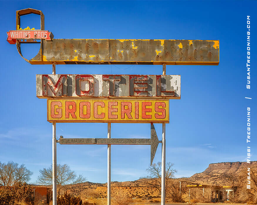
Whiting Brothers Station
421 US Route 66 & Mary St Intersection
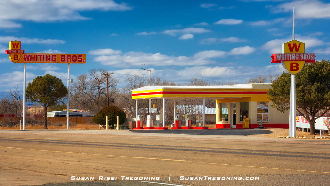
The Whiting Brothers Service Station along Route 66 in Moriarty, New Mexico.
This is a very rare gem! It is the last active Whiting Brothers station with its original Whiting Brothers signage.
It's absolutely perfect, looking just like it did the day it was built. After seeing the ruins of many Whiting Brothers Stations along Route 66, I remember squealing delightfully, "Oh, it's so beautiful!" I never in my life thought I'd say that about a gas station! LOL
Dating to 1954, this is the Whiting Brothers Station number 72. After being a long-time employee at the station, Sal Lucero purchased it in 1985. It's known by the locals as Sal & Inez's Service Station, although I didn't see a single sign with that name on it. While they no longer sell gas here, they are in business as a garage.
These Whiting Brothers signs were restored in 2013. However, I read somewhere that there was a delay during restoration because a family of owls took up residence in one of the signs, and they had to wait for them to move on before finishing the work.
The first Whiting Brothers Station was built in Saint John, Arizona, in 1926 after the Whiting Brothers discovered it didn't take much lumber from their father's mill to construct a very profitable gas station.
Soon, they were popping up all along Route 66 and other areas of the Southwest. When the brothers decided to expand their empire, they added souvenir shops, cafes, and Whiting Brothers Motor Inns next door to their stations.
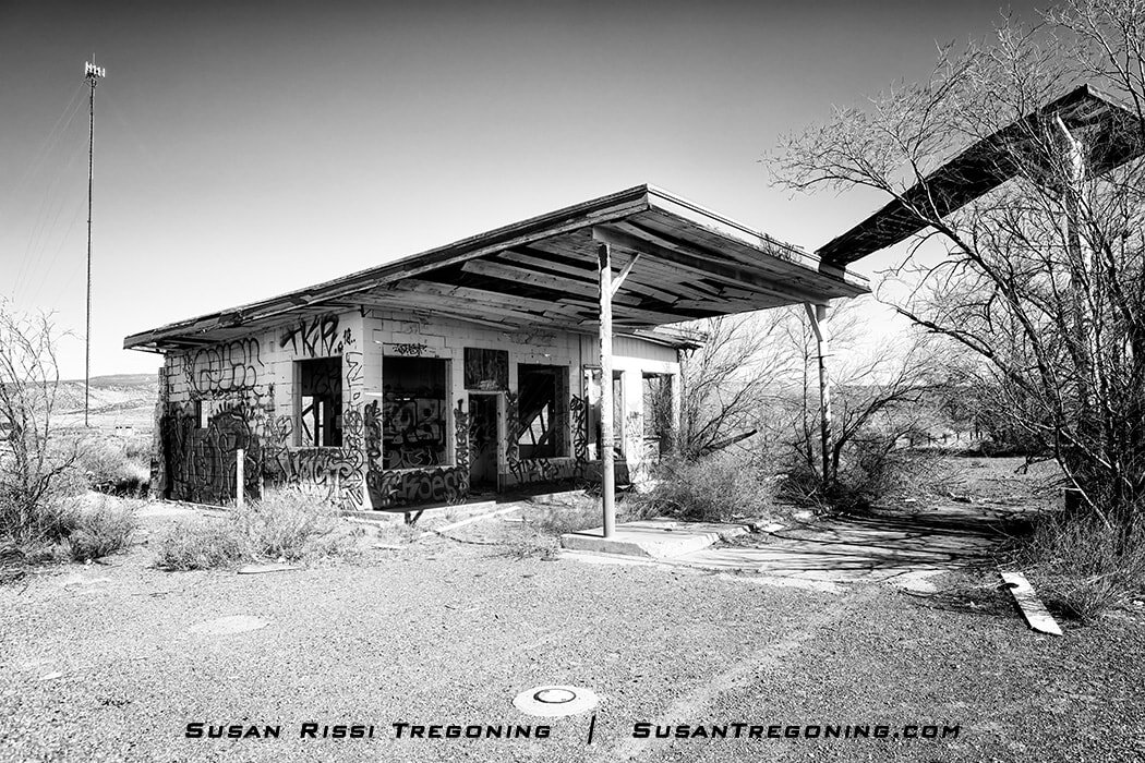
They became a staple along Route 66 and one of the many success stories along the Mother Road. Around 1965, when the company peaked, it owned over 100 filling stations, with at least 40 of them on Route 66. However, business began to decline with the fuel shortages in the 1970s, and then the interstate began bypassing the Route 66 towns. In the 1980s, they started selling off their still viable businesses, and they abandoned some of the other stations they owned. By the 1990s, all that was left of their empire were the fading yellow and orange Whiting Brothers signs and crumbling buildings.
Greene Evans Garage
601 US Route 66
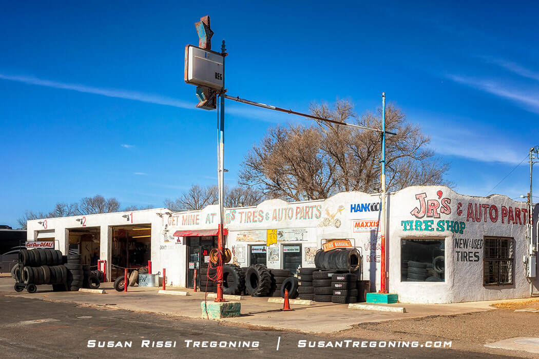
Jr’s Tire and Auto Parts, in Moriarty, New Mexico, is the former Greene Evans Garage, a very early Route 66 gas station.
Jr’s Tire and Auto Parts is the former Greene Evans Garage on the Route 66 commercial strip in Moriarty.
Greene Evans was a local welder who built this stucco Southwest Vernacular garage in 1940 and ran a gas station and garage here for many years. Locals attribute the large fixed window in the building’s southeast curved corner wall as a reminder of Evans’s talent as a skilled welder.
The building was placed on the National Register of Historic Places in 1993 for its importance to Route 66 history in the transportation and architectural categories. The garage was one of the earliest to pop up along the new Route 66 alignment after the Santa Fe Loop was cut off in 1937. It also reflects small-town rural gas station building practices before franchise gas station architecture rose.
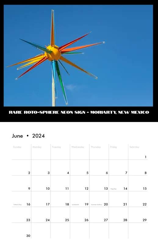
Roto Sphere
1005 US Route 66
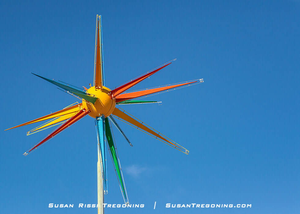
A rare sputnik-style sign, this Roto-Sphere neon sign is located on Route 66 in Moriarty, New Mexico.
This Roto-Sphere sign was installed above the El Comedor de Anayas Restaurant in the 1960s. After being in the elements for 40+ years, it was almost entirely paint-free and deteriorating badly. In 2002, it was chosen as one of the nine vintage Route 66 signs to be restored because it is an extremely rare sign. El Comedor closed in 2013, but the building now houses an antique shop.
Star-like and Sputnik-style signs were all the rage in the 1960s. Many different styles were available, with various arm lengths and numbers of arms. Most did not have neon and were simply eye-catching sign-toppers.
The Roto-Sphere signs were the most elaborate Sputnik-style signs because they were lit and moved. Roto-Spheres had sixteen eight-foot-long multi-colored aluminum spikes outlined in neon mounted on a ball that could spin in three directions. Mass-produced by Warren Milks from 1960 to 1971, he created 234 Roto-Sphere signs. Unfortunately, just twenty Roto-Spheres are still known to exist today, and only ten of those are on public display!
Midway Trading Post
GPS 35°03'00.2"N -106°09'48.2"W
Located on Route 66 between Moriarty and Edgewood. Approximately 1.8 miles east of Edgewood, just past Hwy 11, AKA Williams Ranch Rd/V-Hill Road.
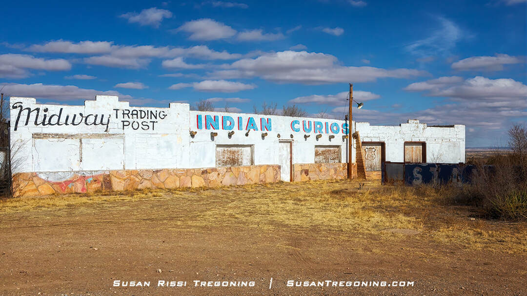
The abandoned Midway Trading Post near Edgewood, New Mexico, once a roadside stop on Route 66, now stands weathered with its faded “Midway Trading Post” and “Indian Curios” lettering.
The Standard sign lies across where the pump island would have been located between the building and the road.
Midway Trading Post was built around 1945. Until it closed in 1972, it served many different capacities within the community. It was a café, gas station, curio shop, post office, community gathering place, and even a municipal court at one time. When I-40 came through, making Route 66 obsolete, there wasn't a nearby interstate ramp for travelers to easily access the Trading Post, so it closed at that time.
It wasn't much more than a canvas for graffiti until 2013, when 60 volunteers spent the weekend giving it a facelift, making it look more like it did in its 1950s heyday.
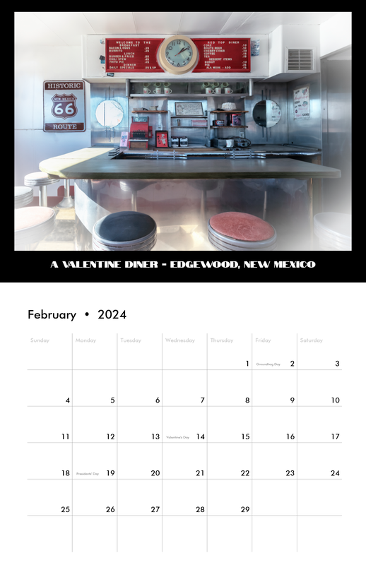
Edgewood
Redtop Valentine Diner
87 North I-40 Frontage Road
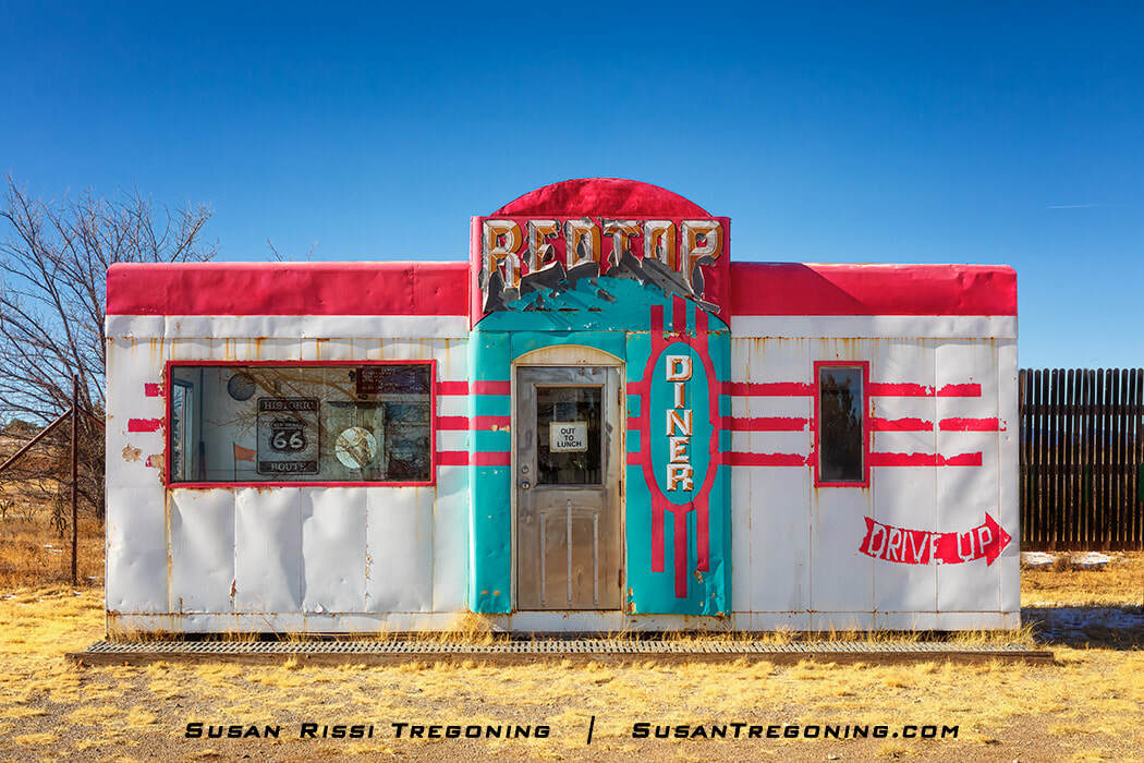
With its bold red trim, turquoise details, and vintage “Red Top” signage, this Valentine diner near Route 66 in Edgewood stands as a colorful reminder of mid‑century roadside dining culture.
This is another gem worth the short side trip off Route 66 to the Wildlife West Nature Park. The diner is in the parking lot right outside the zoo's entrance.
After being vandalized, this eight-stool Aristocrat Valentine Diner, once located in Magdalena, New Mexico, was moved to the Wildlife West Nature Park.
Authur Valentine invented these cute little diners and started producing them in the 1930s. Based out of Wichita, Kansas, Valentine Manufacturing Company made at least 2,000 of these movable prefab diners in different sizes and models, shipping them around the United States. Valentine's company hit its stride in the 40s and 50s with the popularity of Route 66. While nothing fancy, these diners were inexpensive to buy and became an iconic cornerstone for the great American road trip.
Unfortunately, by the 1960s, Valentine began losing business to the fast-food chains that were popping up, and by 1975 the plant closed. As a result, few of these roadside diners remain, and even fewer in their original form.
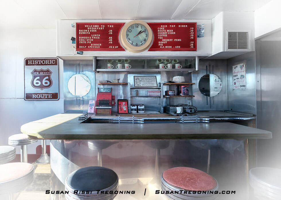
Belly up to the lunch counter at the Red Top Valentine Diner near Route 66 in Edgewood, New Mexico, where chrome details, round stools, and a vintage menu board preserve its classic mid‑century character.
Tijeras
The Musical Highway
The New Mexico Department of Transportation, in conjunction with the National Geographic Channel, installed the Musical Highway in 2014 to encourage drivers to adhere to the speed limit on this otherwise unremarkable stretch of Route 66.
The Musical Highway was considered quite the engineering feat. Individual rumble strips had to be placed at precise distances to produce the notes needed to make the road sing America the Beautiful.
Today, the road is a little out of tune. NMDOT removed the signs for the Musical Highway in 2020 and stopped maintaining it. The speed limit on this stretch of Route 66 has been raised to 55 mph. Even though some notes are missing, it was great fun! Hopefully, they will not patch completely over it anytime soon.
I found these directions elsewhere and thought they were excellent! So good, I managed to shoot this video on our first trip through. I expected to drive this stretch of 66 several times just to locate the musical section.
The Musical Highway is only on one side of the road. Therefore, you must be heading East on Route 66.
I recommend getting on the interstate at Edgewood. The mountain views through Tijeras Canyon are prettier from I-40 since you are centered in the Canyon. I have written the directions that way.
Directions:
Take I-40 Exit 170 at Tijeras. Turn Left onto Highway 333/Route 66 (the first intersection off the interstate.) Drive East for 3.5 miles.
The Musical Highway is shortly after Route 66 curves, goes under the I-40 overpass, and crosses to the south side of the interstate. It is a quarter of a mile long and located between mileposts 4 and 5, but closer to 5.
When you see milepost 4, reduce your speed to precisely 45 mph. Put your passenger side tire as close to the white line as you can without driving on it, and your car will be in perfect alignment with the rumble strip. Then, just when you think you missed it, it will start playing.
Albuquerque
With 18 miles of Route 66 in Albuquerque, not only is it New Mexico’s largest city, but it has the longest urban stretch of the Mother Road of any Route 66 state.
The current Route 66 alignment is Central Avenue. This east-to-west route runs parallel to I-40 and right through the middle of the city.
Tewa Lodge
5715 Central Ave NE
It was built in 1946 in the Pueblo Revival style with rounded parapets, battered and buttressed stuccoed walls to simulate adobe, faux projecting vigas (wooden roof beams), and a flat roof. While the neon sign isn’t original to the building, it is highly regarded along Route 66 as one of the best signs in Albuquerque.
Placed on the National Register of Historic Places in 1998, Tewa Lodge is one of the few motels from the Route 66 era still operating as a motel in Albuquerque.
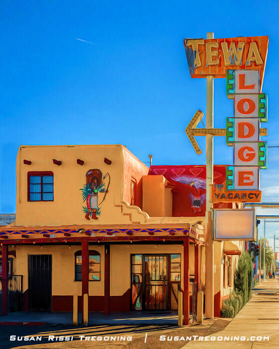
The Tewa Lodge blends Pueblo Revival architecture with vintage neon flair, marking its long‑time presence on Central Avenue, the original Route 66 alignment through Albuquerque.
This paint job on the Tewa Lodge office is fairly recent, and it is cute as a button, but the place is really junked up now. I hope that means they are in the process of renovations.
Recent reviews have been trending down for this motel. At one time, it was said to be the best-preserved historic Route 66 hotel in Albuquerque, but not any longer. Enjoy the architecture from afar, but I would not recommend staying here.
Highland Theater
4804 Central Avenue SE
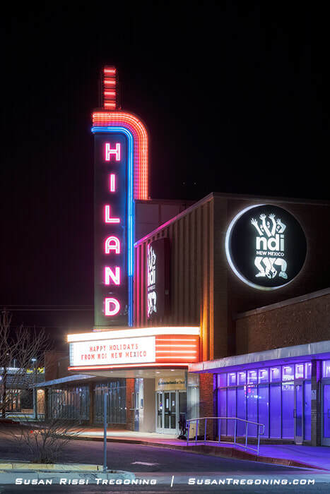
Bold vertical neon and a brightly lit marquee define the Hiland Theater at night, anchoring this stretch of Central Avenue with classic Albuquerque character.
The Hiland Theater was one of four classic theaters built on Route 66 in Albuquerque. It opened in 1950. Designed on the auditorium stadium plan with a raised stepped section at the rear, it seats 1188. The movie theater closed in the summer of 1995. It is now a venue for the NDI New Mexico Dance Studio.
De Anza Motor Lodge
4301 Central Avenue NE

Southwestern architecture and a bold triangular sign define the De Anza Motor Lodge, a classic roadside stop on Albuquerque’s original Route 66 alignment.
The De Anza Motor Lodge was constructed in 1939, two years after the Route 66 realignment through Albuquerque. It was built by a tourist court operator and Charles Wallace, a well-known Zuni Indian trader. Soon, Wallace was the sole owner, offering comfortable lodging and selling Zuni merchandise in the lobby. As a result, the De Anza became a gathering place for traders, Native American artisans, collectors, and tourists.
As Route 66 tourism grew after World War II, the De Anza expanded and remodeled. The number of rooms increased from the original 30 to 55 then to 67. One of the largest Route 66 motels in its day, it had six one-story buildings arranged in a U-shaped courtyard with a pair of two-story buildings in the center. The complex even included a coffee shop/cafe.
The motel remained on the American Automobile Association's approved accommodation list well into the early 1990s. However, after Wallace died in 1993, the motel was sold and resold, eventually closing completely and falling into disrepair.
In 2003, after remaining vacant for many years, the city of Albuquerque purchased the complex.
Before the complex redevelopment project started in 2004, the De Anza Motor Lodge was placed on the National Register of Historic Places as one of the best examples of how a pre-World War II tourist court was altered to remain viable during the golden age of tourism. The motel is also notable as a direct reflection of Charles Garrett Wallace, an important figure in New Mexico's history, during his productive years as an Indian Trader and Route 66 entrepreneur.
Today, this iconic piece of property has been redeveloped in a way respectful to the site's historical nature while keeping it viable. Two of the original smaller buildings, the sign, and Zuni murals, have been preserved. The rest of the motor lodge was demolished in 2017-18 and replaced with a luxury and corporate apartment complex known simply as The De Anza. I think Mr. Wallace would have approved.
Jones Motor Company & Texaco
3222 Central Avenue SE
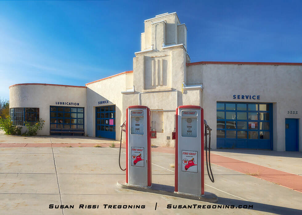
The rounded corners and geometric lines of the Jones Motor Company Texaco highlight its Streamline Moderne design, framed by vintage Fire Chief pumps along Albuquerque’s Route 66 corridor.
Jones Motor Company and Texaco was both a service station and a Ford car dealership. Ralph Jones had it constructed in 1939. Built in the Art Moderne style, with curved walls, a stepped tower, and angled gas tanks, it was considered the most modern station in the West when it was completed.
Ralph Jones advocated for Route 66 and was president of the Route 66 Association, the Albuquerque Chamber of Commerce, and the New Mexico State Highway Department during the mid- and late 1940s.
It was listed on the National Register of Historic Places in 1993 and is currently the home of M'tucci's Bar Roma.
Triangle Park Police Substation
2901 Central Avenue NE
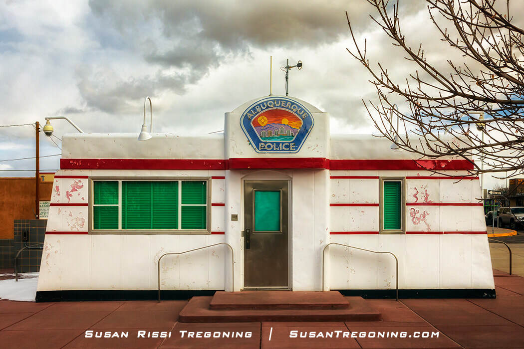
A classic Aristocrat‑model Valentine diner with its streamlined form, horizontal stripes, and compact footprint now houses the APD Triangle Park Substation at Girard and Central on Route 66.
This prefab Valentine Diner is the eight-stool Aristocrat model. Today, it is the Albuquerque Police Department Triangle Park Substation. It can be found on Route 66 at the corner of Girard Boulevard and Central Avenue in Albuquerque's Nob Hill neighborhood.
From 1942 to 1993, locals knew this Valentine diner as the Little House Café. It sat at the intersection of 8th and Central.
After the business closed, the owners donated the building and contents to the Albuquerque Museum, where it sat in storage until sometime around 1997, when someone suggested that APD use it for their Nob Hill substation—placing this importation piece of Albuquerque Route 66 history back out on the street. The Albuquerque Police Department has been using it ever since.
66 Diner
1405 Central Avenue NE
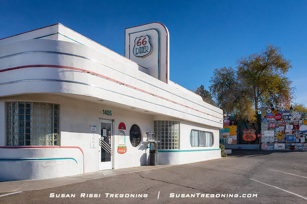
Streamlined curves, glass block windows, and bold vertical signage define the 66 Diner, a standout example of retro‑inspired architecture along Central Avenue’s Route 66 corridor.
The 66 Diner was originally Sam’s Sixty-Six Service Station, a Phillip’s 66 gas station, constructed in 1946.
In 1987, the building was converted into a diner. The renovation kept much of the original building's Streamline Moderne design elements intact. The clean, curvy lines, glass block corner windows, and neon trim are all original to Sam’s Sixty-Six. Even the hydraulic lift that was once in Sam’s Garage is still here, reinvented as the restaurant’s hopscotch court!
This perfect piece of 1950s roadside architecture comes to life at night when lit!
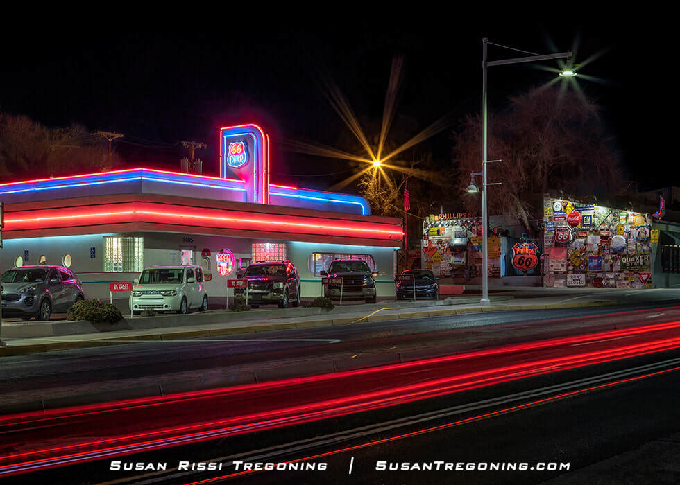
The 66 Diner lights up Central Avenue with vivid red, blue, and pink neon, while long‑exposure tail‑light trails emphasize its place on Albuquerque’s Route 66 streetscape.
Kimo Theatre
423 Central Avenue NW
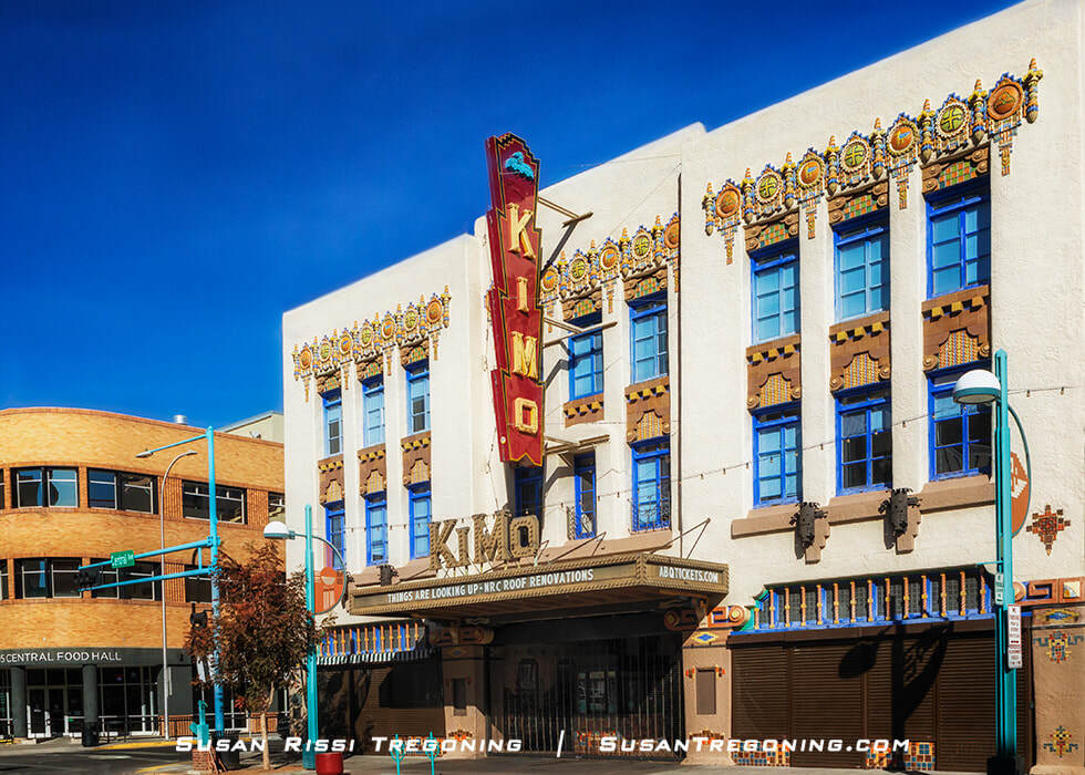
A standout example of Pueblo Deco design, the KiMo Theatre blends Art Deco geometry with Indigenous motifs along Albuquerque’s historic Route 66 corridor.
Constructed in 1927, the KiMo was the first theater built in the Pueblo Deco style, a fusion of American Indian and Art Deco. The building is unique since Chinese and Egyptian were the predominant design styles for the elaborate film palaces in the 1920s. No longer just a movie theater, today it also hosts a mix of concerts, plays, ballet, and much more. “Kimo” is Pueblo Isleta for “King of its kind.”
The exterior is embellished with ornamental glazed terracotta tiles and vivid colored reliefs. You’ll see swastikas on the front of the building, which is the Navajo symbol of life, freedom, and happiness. It was applied to the front of the KiMo long before it became known as the symbol of Nazi Germany. The marquee and vestibule date to the 1950s. The KiMo was added to the National Register of Historic Places in 1977.
If you want to see the interior of the KiMo Theater, check out their upcoming events.
El Don Motel
2220 Central Avenue SW
The El Don Motel neon sign has recently been restored, bringing new life to one of Albuquerque’s classic roadside icons. Its bold turquoise panel and animated cowboy on horseback—lasso raised in hand—capture the playful, mid‑century character that once defined the city’s motor‑court era.
Route 66 through Albuquerque is vintage “Motel Row,” a stretch where historic lodges, classic architecture, and brilliantly colored neon still line Central Avenue. It’s here that you’ll find some of the coolest and most enduring signs on the Mother Road, each one a reminder of the era when roadside design was as much an art form as a beacon for travelers.
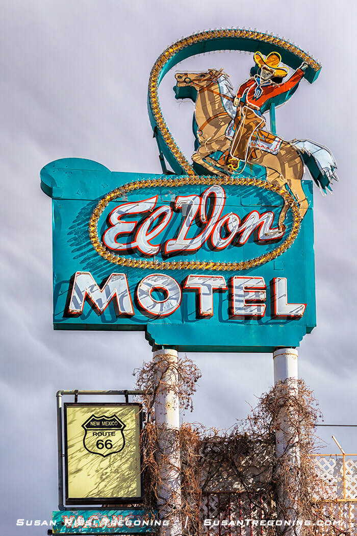
A classic piece of Albuquerque roadside history, the El Don Motel sign stands along Historic Route 66 with its bold turquoise panel and cowboy‑on‑horseback motif.
El Vado Auto Court Motel
2500 Central Ave SW
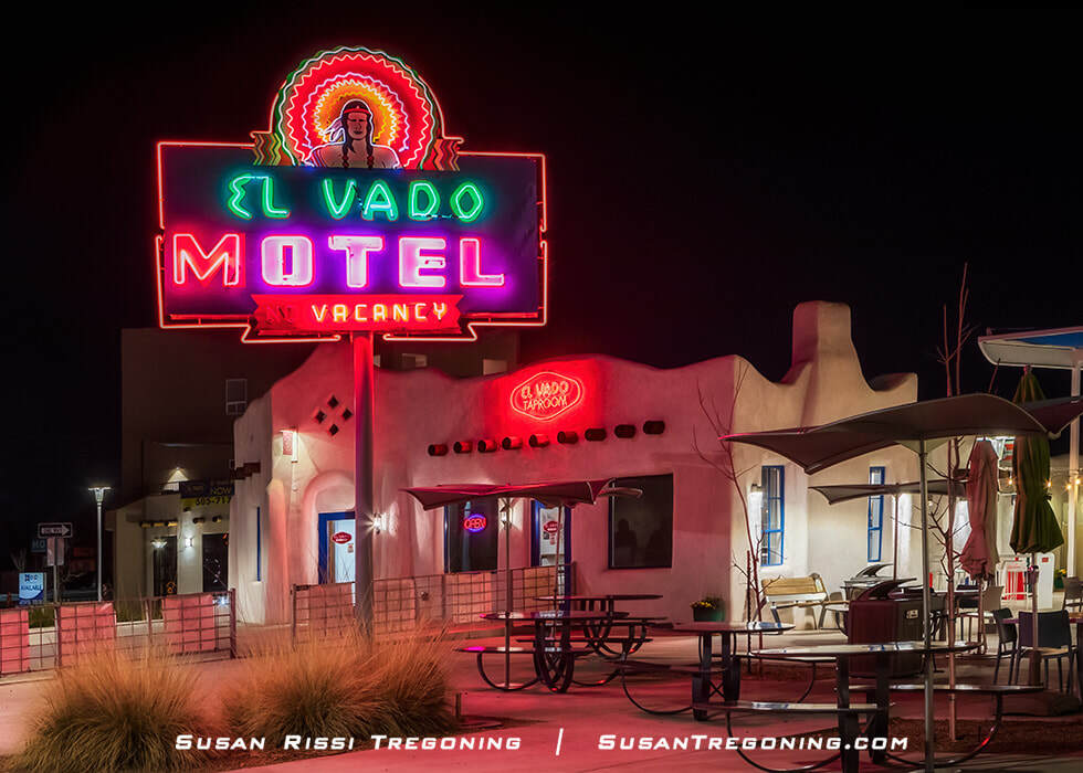
The El Vado Motel glows along Historic Route 66, its beautifully restored neon sign illuminating one of Albuquerque’s most iconic motor‑court landmarks.
Reopening in 2018 after an $18 million award-winning redevelopment project, the El Vado Auto Court is Albuquerque’s latest Route 66 motel to be revitalized!
Albuquerque’s oldest Route 66 tourist court on the current alignment, Irish immigrant Daniel Murphy, built the El Vado in anticipation of the Route 66 realignment, opening the motel in 1937. The motel was designed in the popular Spanish Pueblo Revival style and had thirty-two rooms with adjoining carports and a gas station. Quite the showplace in its day, a write-up in the Albuquerque Progress described the rooms as “swanky tile cabin suites ready for the summer tourist trade.”
The El Vado was placed on the National Register of Historic Places in 1993, cited as one of the best examples of a pre-World War II motel in New Mexico. It has also been designated a City Landmark and listed on the New Mexico State Register of Cultural Properties.
The motel closed in 2005. The city purchased the El Vado in 2010 and began looking for a partner on board with their historic preservation and redevelopment plan. The concept was to preserve the existing buildings while bringing new life and activity to the complex and surrounding area through adaptive reuse.
In 2018, the El Vado reopened as a boutique motel elegantly furnished with custom-crafted mid-century modern furniture. The motel was reduced to twenty-two rooms making room for a centrally located community food court with food pods and retail spaces, a taproom, pool, and events center.
The El Vado revitalization project won the 2019 NMAF award “for important historic buildings or sites that have had a lasting effect upon bringing together our community.”
Check out El Vado’s website to make reservations and see interior images of this iconic Route 66 motel.
Route 66 Crossing Sign
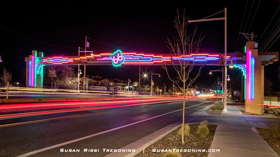
Colorful neon illuminates the Route 66 Crossing Sign at night, marking one of Albuquerque’s most striking gateways along Historic Route 66
Western View Steakhouse, at 6411 Central Avenue NW, is another classic Route 66 icon—and it’s the address many travelers use to pinpoint the Route 66 Crossing Sign. Located at the far west end of Albuquerque’s stretch of the Mother Road, the illuminated gateway spans all four lanes of Central Avenue/Route 66, creating a bold neon archway over the traffic below.
When lit at night, the sign’s colorful geometric patterns and glowing Route 66 shield are especially striking. It's one of the most memorable nighttime landmarks along Albuquerque’s historic corridor.
Albuquerque's Pre-1937 Route 66
Albuquerque is the only location along the Mother Road where Route 66 crosses itself.
Both alignments of Route 66 intersect at Central Avenue & 4th Street in the Downtown District, not far from the KiMo Theatre.
The Pre-1937 Route 66, AKA Santa Fe Loop, ran north to south through Albuquerque on 4th Street. The most significant stretch of sites dating to Pre-1937 Route 66 is in the Barelas-South Fourth Street Historic District.
Unfortunately, it took several attempts to find this area of town because the National Park Service failed to place the SW after each address.
Please note: The correct address is... 4th Street SW.
The only remaining Pre-1937 Albuquerque motor court is on the north side of 4th Street, and their restaurant is still in business across the street.
El Camino Motel - 6851 4th Street NW, Los Ranchos de Albuquerque
El Camino Dining Room - 6800 4th Street NW, Los Ranchos De Albuquerque
Mesita
Owl Rock
1.7 miles west of Mesita on Old Route 66
Just around the curve, Owl Rock rises from the desert landscape, a striking sandstone formation along this quiet stretch of the Southwest.
This giant rock sits right next to Route 66, about two miles past Mesita, New Mexico. It has been named Owl Rock because the rock formation resembles an owl.
I love how the Mother Road twists and turns around this fantastic rock formation instead of removing it like they would have done if it was on I-40. After passing Owl Rock, Route 66 curves to the right, no longer running parallel to I-40. The deadly 180-degree Dead Man’s Curve is not far from here, and it curves around the rock wall in the distance.
I read somewhere that in Native American culture, an owl symbolizes evil, death, or a bad omen. I find this fascinating since Dead Man’s curve is just past here. But, of course, this only applies if you are headed west.
Does it look like an owl?
If you follow the natural contours:
The rounded upper mass reads like the owl’s head.
The vertical shadow line suggests the divide between “eyes.”
The broader base gives the impression of a perched body.
The slight forward lean mimics the posture of an owl watching the road.
It’s not a perfect silhouette, but the overall massing, stance, and proportion absolutely evoke an owl — especially when you know you’re approaching Owl Rock and your brain is primed to see it.
Notice how I-40 and Route 66 are almost perfectly aligned and then curve away from each other in this image.
San Fidel
Whiting Bros. Station
2.7 miles west of San Fidel on NM 124 AKA Route 66 OR .5 miles east of I-40 Exit 96
Faded paint and rusted metal mark what remains of this Whiting Brothers sign, its arrow directing travelers toward the crumbling foundations of a former gas station along the old highway.
Whiting Brothers Gas Station number 39 was once part of a large complex built here in the 1940s. According to Jack Rittenhouse's A Guidebook to Highway 66, first published in 1946, "two miles west of San Fidel: Chief's Rancho Café here, with gas, grocery, curios, and cafe."
Unfortunately, the buildings were lost in a fire sometime in the 1990s. All that remains is the front of this Whiting Brothers Gas Station. As a result, the arrow on this old Whiting Brothers sign now points to an empty concrete slab.
Graffiti‑covered walls and a collapsing canopy are all that remain of this Whiting Brothers Service Station and Motel on NM‑124, a fading relic from the early days of Route 66 travel.
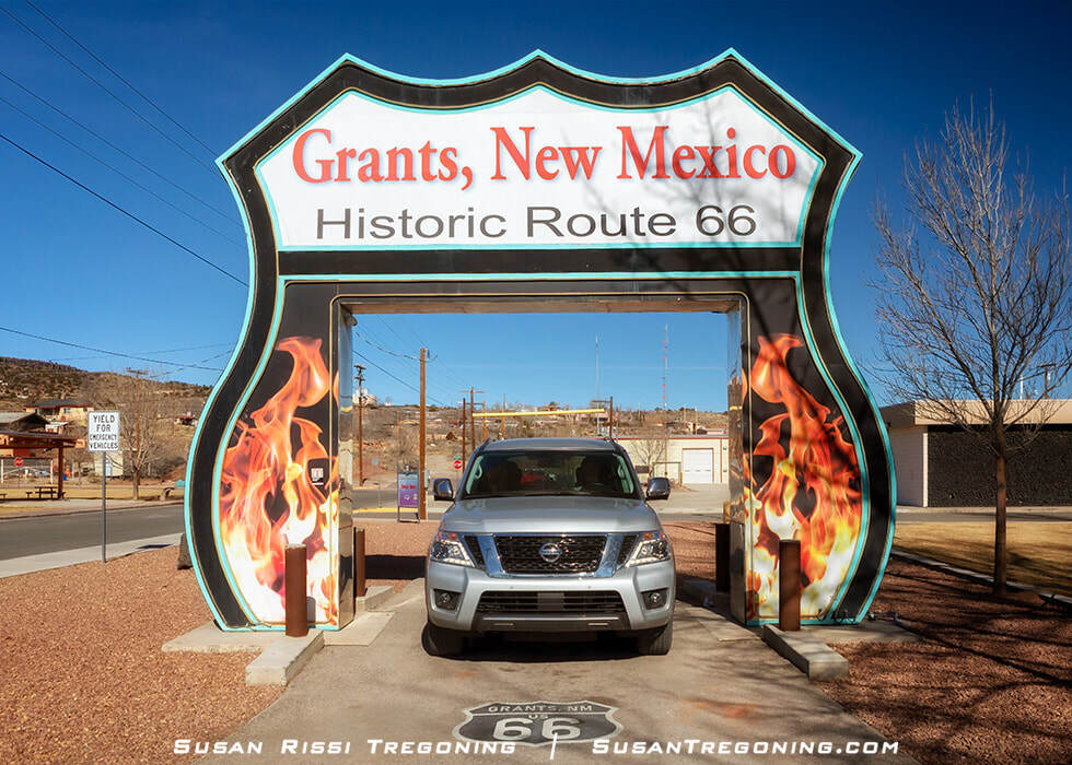
Grants
First known as Grant's Camp, a railroad camp ideally situated halfway between Albuquerque and Gallup. The town of Grants sprang up from the lava fields in the 1880s when the Atlantic and Pacific Railroad contracted three Canadian brothers named Grant to lay the tracks through the malpais (lava fields). Since the area had abundant water and wood, the fledgling town flourished when the Railroad placed a train station there.
From the beginning, the town of Grants had several significant booms. First, the Railroad brought railroad logging to the area. As logging began declining in the 1930s, the rich volcanic soil was perfect for farming, and the town was soon known as the "Carrot Capital of the United States." Then, Route 66 arrived in 1926; with the beginning of the tourist trade, motels, diners, service stations, and garages began popping up. After Uranium Ore was discovered in the 1950s, the Uranium mine and its many auxiliary businesses created nearly 6,000 new jobs. Unlike other small towns along the Mother Road, the loss of Route 66 through the center of town was barely noticed when I-40 bypassed the town in 1974. It wasn't until the Uranium mine closed in the 1980s that Grants began to decline.
El Malpais National Monument
1900 E Santa Fe Avenue
Sands Motel
112 McArthur
The Sands Motel sign on Santa Fe Avenue points toward a classic 1950s budget motel tucked just off the main Route 66 corridor. Its simple mid‑century design and quiet side‑street location make it one of those understated Mother Road holdouts that still carries the feel of early roadside travel.
According to the motel’s owners, Elvis Presley stayed in room 123 in 1967 while passing through on his way to Las Vegas to marry Priscilla. The room has since become a small tribute to that moment in pop‑culture history, decorated with Elvis memorabilia—including a copy of the couple’s “Affidavit for Application for Marriage” displayed on the wall.
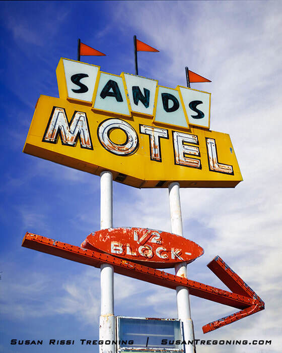
Bold colors and simple mid‑century styling define the Sands Motel sign on Route 66 in Grants, its arrow still directing travelers toward the modest 1950s motor court just a half‑block away.
Story or truth, who knows for sure? Elvis liked to spread misinformation to avoid screaming fans. The Memphis Mafia claims that Elvis spent that night in Palm Springs.
It’s the kind of story that blends Route 66 lore with American music history, adding another layer of charm to this modest New Mexico motel.
West Theater
118 W Santa Fe Avenue
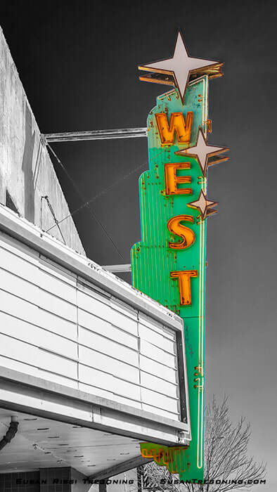
West Theater is the last theater still operating in Grants, New Mexico, its vintage marquee and star‑topped neon sign preserving the charm of the town’s mid‑century Route 66 era.
I love this vintage neon sign at the West Theater. Even in daylight, its star‑topped design and bold mid‑century lines are irresistible, but I wish I had been there after dark. Locals say the largest star at the top flashes, and the whole sign becomes even more colorful and animated when lit — a classic small‑town neon moment that feels straight out of Route 66’s golden era.
J.C. West purchased the El Sol Theater while it was still under construction, completing the building and reopening it as the West Theater in 1959. Ever since, it has shown first‑run movies and remained a community anchor. Today, it stands as the last operating theater in Grants, a rare survivor of the era when nearly every Route 66 town had its own marquee glowing over Main Street.
The Roarin' 20s Sign
W. Santa Fe Avenue & 3rd Street Intersection
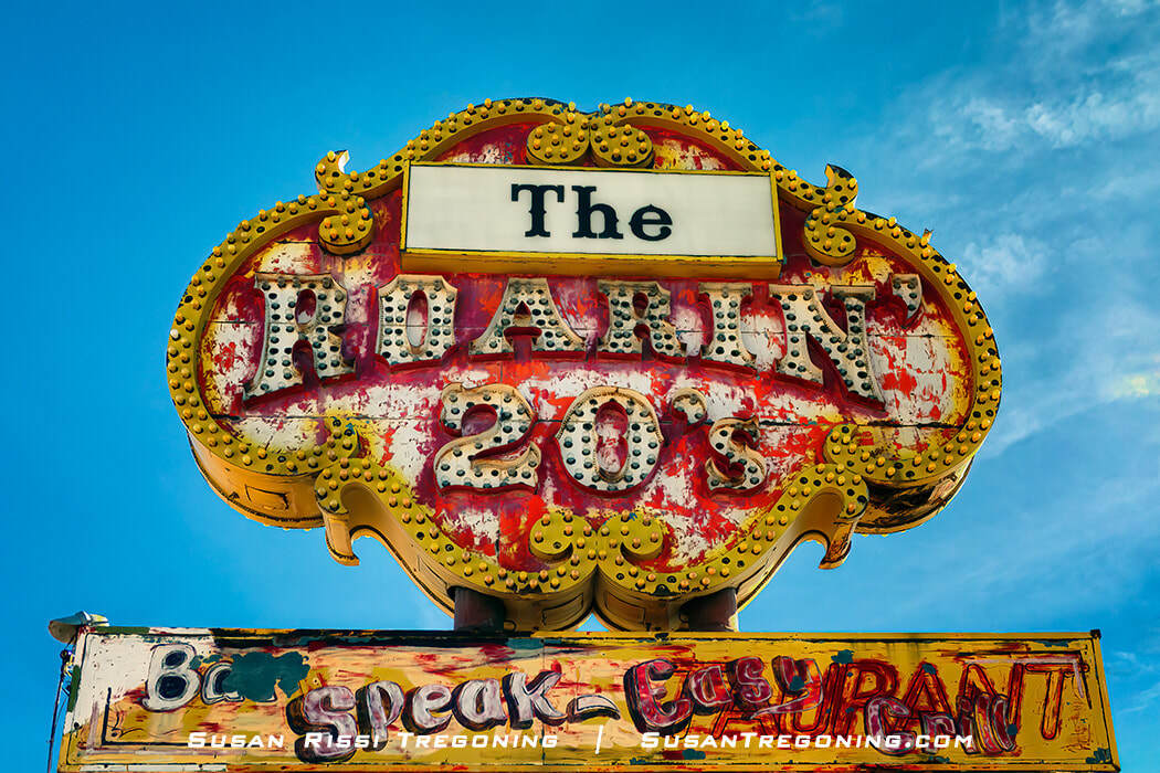
Weathered paint and chipped neon give the Roarin’ 20s sign in Grants a nostalgic charm, a reminder of the once‑lively speakeasy‑themed restaurant that stood along Route 66.
There is such a fantastic patina on this ornate Roarin' 20s neon sign! You can tell by the ghosted words this sign has had many reincarnations in its lifetime, from Speak-Easy to Restaurant to Bar & Grill. The sign has even been used for a package liquor store.
This vintage neon sign dates to the 1960s. It was initially the signage for a topless restaurant and bar on Route 66 in Albuquerque, New Mexico.
After it closed, Eddie McBride bought the sign, moving it to Grants for his father's property on Santa Fe Avenue. Louis McBride, Sr. (Eddie's father) and his wife owned the Sunshine Café, Bar, and Dance Hall. The Sunshine Café was a mom-and-pop café that served New Mexican food. The Sunshine Dance Hall most likely opened around the 1920s and was packed every Saturday night.
The sign now stands alone in an empty lot.
Route 66 Drive-Thru Arch
600 W Santa Fe Avenue
The Route 66 Neon Drive‑Thru Arch in Grants is shaped like a giant highway shield, a glowing tribute to the Mother Road that lights up the night with bold color and classic roadside flair.
This is a fun little photo op! The Route 66 Neon Drive-Thru Arch is shaped like a Route 66 highway shield sign and is lit at night.
Hollywood Diner
1023 W Santa Fe Avenue
The faded and rusted remains of the Hollywood Diner neon sign can still be seen over the long-closed Valentine “Double Deluxe” Diner.
The Hollywood Diner opened in 1955. At the time, it was said to be frequented by Hollywood actors who were filming nearby.
The building has been modified over the years and used for many different businesses since the diner closed, but it still has its distinctive wing on the front, which indicates a Valentine Diner. The Double Deluxe was Valentine's largest model, seating 36 people.
Weathered paint and peeling neon mark what’s left of the Hollywood Diner sign, perched above a classic Valentine “Double Deluxe” Diner along Route 66 in Grants — a quiet reminder of the era when small diners lined the Mother Road.
Authur Valentine invented these mail-order diners and started producing them in 1947. Based out of Wichita, Kansas, Valentine Manufacturing Company made at least 2,000 movable prefab diners in different sizes and models, shipping them around the United States. Valentine's company hit its stride in the 40s and 50s with the popularity of Route 66. While nothing fancy, these inexpensive diners became an iconic cornerstone for the great American road trip. Unfortunately, by the 1960s, Valentine began losing business to the fast-food chains that were popping up, and by 1975, the plant closed. As a result, few of these roadside diners remain.
Charlie's Radiator Service
1310 W. Santa Fe Avenue
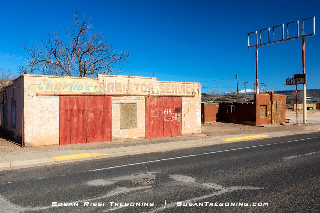
On the west end of Grants, Charlie’s Automotive Service stands alone as the final survivor of the Route 66 auto‑trade buildings that once lined this stretch of the Mother Road.
Charlies Radiator Service is the only surviving building on the west end of town that catered to the early Route 66 automotive trade.
Charles Diaz built Charlie’s Radiator Service when he was 29 years old with the help of his grandfather, an Italian immigrant stonemason. The building was constructed out of pumice block, which weighs about 50% less than concrete blocks.
A prime location along Route 66, Charlie opened his business in 1943 with two gas pumps, a garage, and a body shop. He originally sold Mobil brand gasoline, but there were so many service stations on the west end of town that competition was tough. So, Charlie decided to remove the gas pumps and specialize in radiator repair instead. This was a wise decision since he lost considerable property in front of the garage when the city widened Route 66 to four lanes. Charlie ran the business until he died of a heart attack in 1995.
Charlie’s great-uncle built the Star Café next door to the garage in 1949. After the Uranium mine opened, the café did a booming business selling prepacked lunches to miners who used the nearby bus stop to commute to work. Around this same time, the café expanded into a drive-in that was open 24 hours a day. After the restaurant closed in 1985, it became a tire shop.
The Diaz family home was located behind the garage and café.
The five-building complex was placed on the National Register of Historic Places in 2017.
Continental Divide
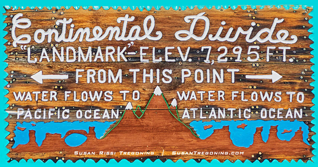
While there’s an official Continental Divide sign along the highway, this quirky version was my favorite — a fun, offbeat reminder of where the waters part along New Mexico’s stretch of Route 66.
At 7,295 feet, the Continental Divide is the highest point along New Mexico’s stretch of Route 66, a quiet rise in the landscape where the waters of North America split and flow toward opposite oceans. There’s not much here today—just a few trading posts, the remains of an old Whiting Brothers Hotel, and this sweeping view of the red Entrada Sandstone cliffs.
It’s an unexpectedly beautiful stop: wide‑open sky, rugged layers of desert rock, and that unmistakable sense of standing on a natural boundary that shaped both geography and travel. While there’s an official Continental Divide sign along the highway, this spot was my favorite, a more intimate reminder of how much history and scenery still line the Mother Road.
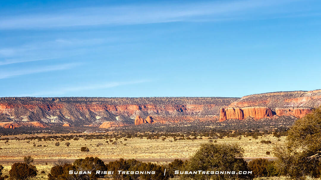
From the Continental Divide, the Entrada Sandstone cliffs dominate the horizon, their bold red walls creating a stunning backdrop along this high‑desert section of Route 66.
Pulling off behind the trading posts for the magnificent view of the cliffs is absolutely worth it. The red Entrada Sandstone first appears around Prewitt, about 16 miles east of the Continental Divide, marking your entry into the Colorado Plateau—the last of New Mexico’s four major land regions.
From here, these dramatic cliffs become a constant companion as you continue west. Their deep red layers, carved by time and weather, rise sharply above the desert floor and create some of the most striking scenery along this stretch of Route 66. The formations continue all the way into Arizona, guiding you out of New Mexico with the same bold, rugged beauty that greeted you on the way in.
Gallup
El Rancho Hotel
The intersection of 1000 E Route 66 & Ford Drive
For the ultimate vintage luxury Route 66 experience, the historic El Rancho Hotel should be your #1 choice for a night in Gallup, New Mexico. You can check dates, rates, and make reservation here.
Sleep where Movie Stars like Ronald Reagan, John Wayne, Katherine Hepburn, Spencer Tracey, Errol Flynn, Kirk Douglas, Gregory Peck, and Humphrey Bogart made their temporary home during the golden age of Hollywood. Just to name a few of the stars that lived here while they filmed Westerns such as The Bad Man (1940), Sundown (1941), The Desert Song (1942), Four Faces West & Colorado Territory (1947-1948), Streets of Laredo (1948), Rocky Mountain (1950), Raton Pass (1951), Fort Massacre (1957), A Distant Trumpet (1963) and The Hallelujah Trail (1964), in the area.
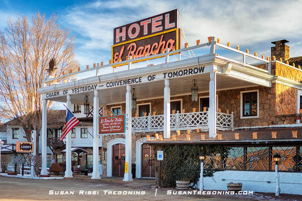
The building’s façade is reminiscent of a Southern plantation, with tall columns supporting a second‑floor portico that gives the structure a distinctly classical presence. The symmetry and columned frontage echo antebellum architectural influences, making it stand out sharply from the more utilitarian roadside buildings typically found along historic Route 66.
Constructed in 1936 for R.E. "Griff" Griffith, the brother of the famous movie director D.W. Griffith, the El Rancho Hotel was designed by architect Joe Massaglia. The hotel has all the grandeur of old Hollywood and a picturesque "fantasy of the Old West," a rustic western style rarely found in Gallup. While the El Rancho is a large rambling 70-room hotel, the main lobby and early rooms are centrally located within a three-story square building.
From the beginning until the mid-1960s, El Rancho was the center of the movie industry in Gallup. The Griffith brothers encouraged movie makers to use their hotel as its base for their stars and crew because of its proximity to striking western landscapes and extravagant elegance boasting of superior service with its employees trained by the famous Fred Harvey Company.
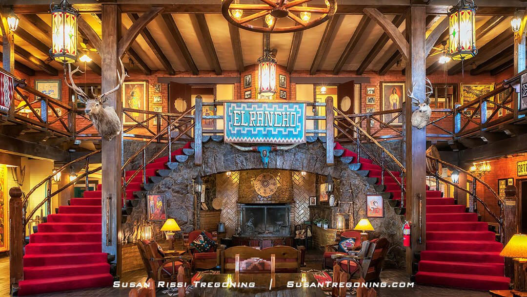
The El Rancho Hotel lobby welcomes travelers with its curving log staircases, walk‑in stone fireplace, and richly layered western décor — a signature blend of rustic charm and cinematic Route 66 history.
The main entry leads into an elaborate two-story lobby that meshes the feel of a hunting lodge with rusticated western grandeur. The lobby's focal point is a double staircase of split logs with railings of naturally bent tree limbs that have been stripped and highly polished. The elaborate staircase wraps around a spectacular walk-in stone fireplace intimately set back into a cove under the balcony that wraps around the room's perimeter. Furnishings of heavy dark wood, Navajo rugs, and deer heads complete the look.
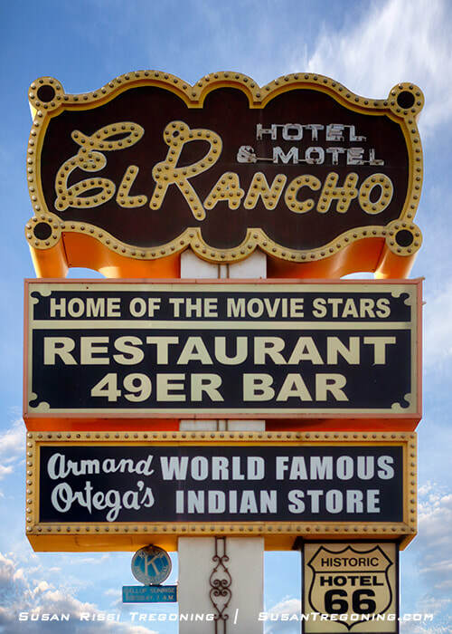
The El Rancho’s vintage neon sign stands as a beacon of the hotel’s storied past, recalling the era when movie stars and Route 66 travelers filled its grand lobby.
By 1964, Interstate 40 was almost completed. Route 66 and the mystic of the West were fading along with the popularity of Western movies. The El Rancho began to fade along with it. The hotel went through a series of different ownerships. Finally, Armand Ortega, a well-known local Indian trader, saved it from demolition by purchasing it 50 years after its grand opening at a bankruptcy auction.
The El Rancho Hotel was placed on the National Register of Historic Places in 1988, and after extensive restoration work, it reopened that same year.
General Route 66 Trip Planning
Route 66 is the ultimate great American road trip, but most people will never drive it entirely from one end to the other. You could easily spend weeks or months on Route 66 and still not see it all.
Three weeks to a month seems to be the agreed-upon time to allow for a satisfying but still abbreviated road trip on Route 66, with 14 days being the absolute minimum. This is long enough to do the complete drive without feeling rushed and keep it fun as long as you carefully select the sites you wish to visit and limit your museum stops. However, don't spread yourself too thin, or you will just be frustrated by everything you've missed along the way.
Somewhere between 100 to 175 miles a day seems to be the average agreed-upon distance to travel in a day. A Route 66 road trip is much different than a typical vacation since it's all about the sites you see along the way and not the final destination.
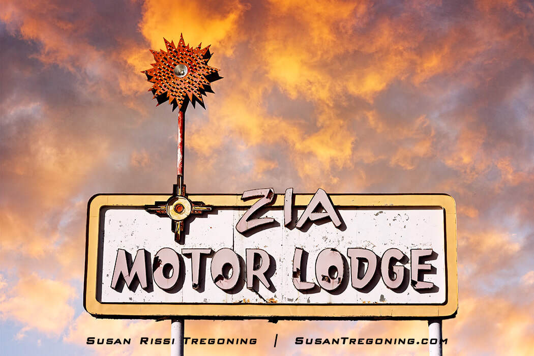
Albuquerque has a wonderful habit of preserving its Route 66 neon, even when the structures beneath it disappear. The Zia Motor Lodge sign—dating to the 1960s—is the last trace of a 1938 family‑run motel built after the highway shifted through Tijeras Canyon. Though the lodge closed in 2002 and was demolished a year later, the sign still stands and even made a cameo in Season 4 of “Breaking Bad.”
While on assignment in Albuquerque, I traveled the New Mexico section of Route 66 during the off-season. Almost all of the museums were closed. I only found two museums open, and I stopped at those. Admittedly, as a photographer, I spend more time than average at what I consider photo-worthy locations, so keep that in mind, too. I averaged about 90 miles daily, and it has taken me 12 days to do Texas, New Mexico, and 1/2 of Arizona. That seems like a lot of time to devote to that stretch of road, but after joining a couple of Facebook Route 66 groups, I'm already having "Awe, how did I manage to miss that" moments. I have also stuck strictly to the Route 66 sites and not taken any "side trips" like Palo Duro Canyon near Amarillo, Texas.
My point is, that there is no right or wrong way to experience Route 66. You can do it all at once, but you don't have to. Start with one or two states and work up from there. Start in Chicago, drive west or Santa Monica, and head east or even somewhere in the middle. Stick religiously to the Route or jump off and on from the interstate.
Pick an area of interest, like kitsch, museums, historic locations, or food, and just do that. It's entirely your road trip to plan.

The Handy Andy Groceries neon sign rises above Route 66 in Grants, one of those small but unforgettable pieces of mid‑century roadside charm that still define the Mother Road.
Every town has a story to tell, some happy, some sad, but they all come from the heart. Along the way, you'll find quirky roadside attractions, museums, ghost towns, natural beauty, and amazing architecture. This iconic road is packed with so many things to see and do. Once you get started, I guarantee you will want to see more.
The Best Time of Year to Drive Route 66
April through the middle of October is widely considered the best time of the year to drive Route 66. Too early or late in the year, and you risk running into snow and ice along the Mother Road. Unless it's a stretch of road through a town, the lesser-used sections of Route 66 are not cleared in the winter.
Many museums close completely or have limited hours and days open during the off-season. In addition, some restaurants and smaller mom-and-pop motels may be closed for maintenance since they run seven days a week during peak season.
I'm not sure if this is because I also visited during a COVID year, or it is typically like this, but the days and hours open are not updated on websites or Facebook. I would recommend calling if there's someplace you are highly interested in visiting before making a special trip.
Also, be aware that the monsoon season in the desert southwest is from the middle of June through the end of September. Therefore, if you plan to drive portions of Dirt 66, it may be too muddy to do so during the rainy season.
Here are some resources that I used while planning my Route 66 road trip.
Book - EZ66 Guide for Travelers by Jerry McClanahan
The directions you need to help you find Route 66 and keep you on it.
Historic Route 66 Facebook Group
New Mexico Route 66 Interactive Map
Be sure to check out my other Route 66 blog post!
The Best of Illinois Route 66
Red Oak II: A Missouri Route 66 Gem
Old Chain of Rocks Bridge: A Route 66 Gem between Illinois and Missouri
All images are available for purchase as fine art prints and wall art, home decor, gift items, and apparel in my Image Gallery.

“Route Reflections” — A bold celebration of vintage Americana, capturing the chrome curves and rocket‑fin flair of mid‑century roadside design against a fiery sky. Perfect for industrial, automotive, or modern masculine interiors.

Susan