Old Chain of Rocks Bridge: A Route 66 Gem between Illinois and Missouri
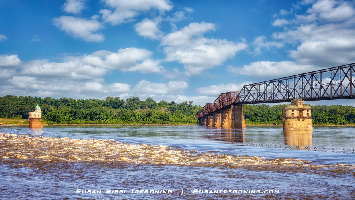

A Mississippi River view from beneath the Old Chain of Rocks Bridge, where the intake towers and the Chain of Rocks shoal define this historic crossing.
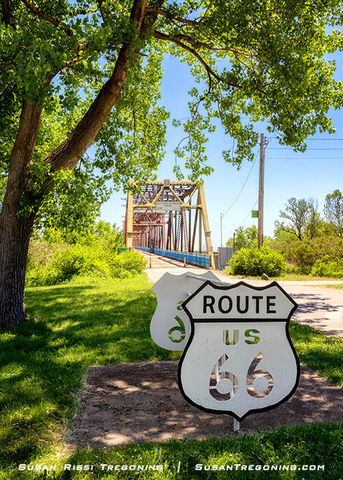
Constructed almost 100 years ago, at the beginning of America's love affair with the automobile and reinvented as a pedestrian and bicycle bridge, the Old Chain of Rocks Bridge is a MUST-VISIT attraction for every Historic Route 66 pilgrimage.
It is an easy two-mile round trip hike or bike across this historic old bridge that soars high above the Mississippi River between Madison, Illinois, and St Louis, Missouri, at one of the river's most scenic locations near its confluence with the Missouri River. Even if you can't go the complete distance, you can drive down the road to the left just before entering the parking lot, where you can admire the Old Chain of Rocks Bridge from the base of the Mississippi River.
The Old Chain of Rocks Bridge was named after the 17-mile-long shoal in the river, the Chain of Rocks, a series of underwater rock ledges that create rapids, making boat navigation extremely dangerous.
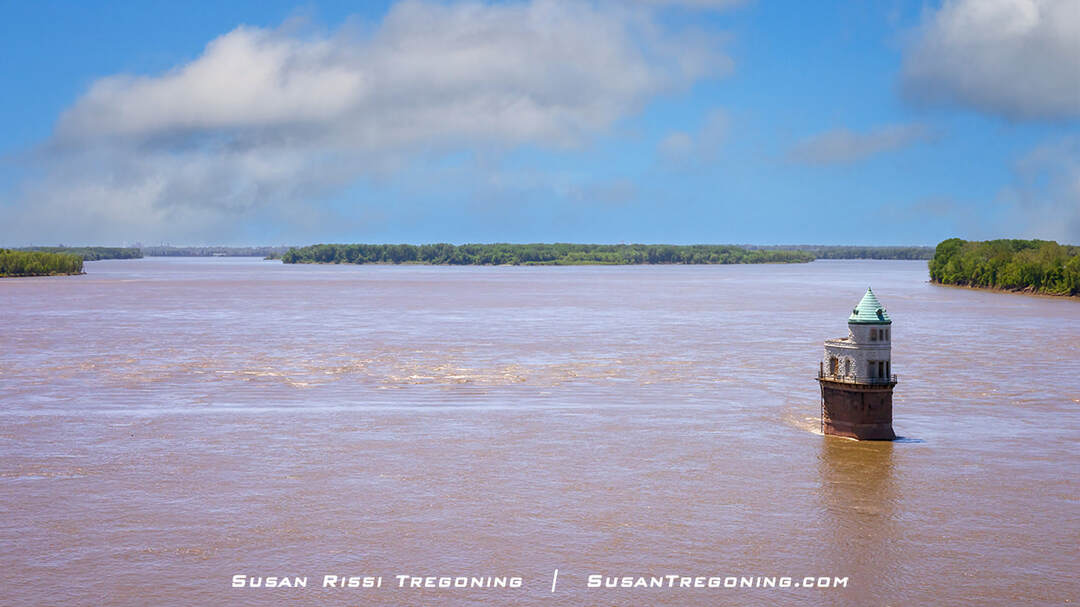
Intake tower #1 of the St. Louis pumping station, photographed from the Old Chain of Rocks Bridge at the Chain of Rocks section of the Mississippi River, with the city barely visible beyond.
The bridge is near the enchanting water intake towers for the Chain of Rocks pumping station and is infamous for its unusual 30-degree bend near its center. At 5353 feet long and slightly longer than a mile, it is one of the longest continuous steel truss bridges in the United States. It is also the longest Route 66 river crossing. The piers for the bridge are 55 feet above the Mississippi River's high water mark, giving you a view of the St Louis Arch above the trees some 20+ miles away.
Old Chain of Rocks Bridge History
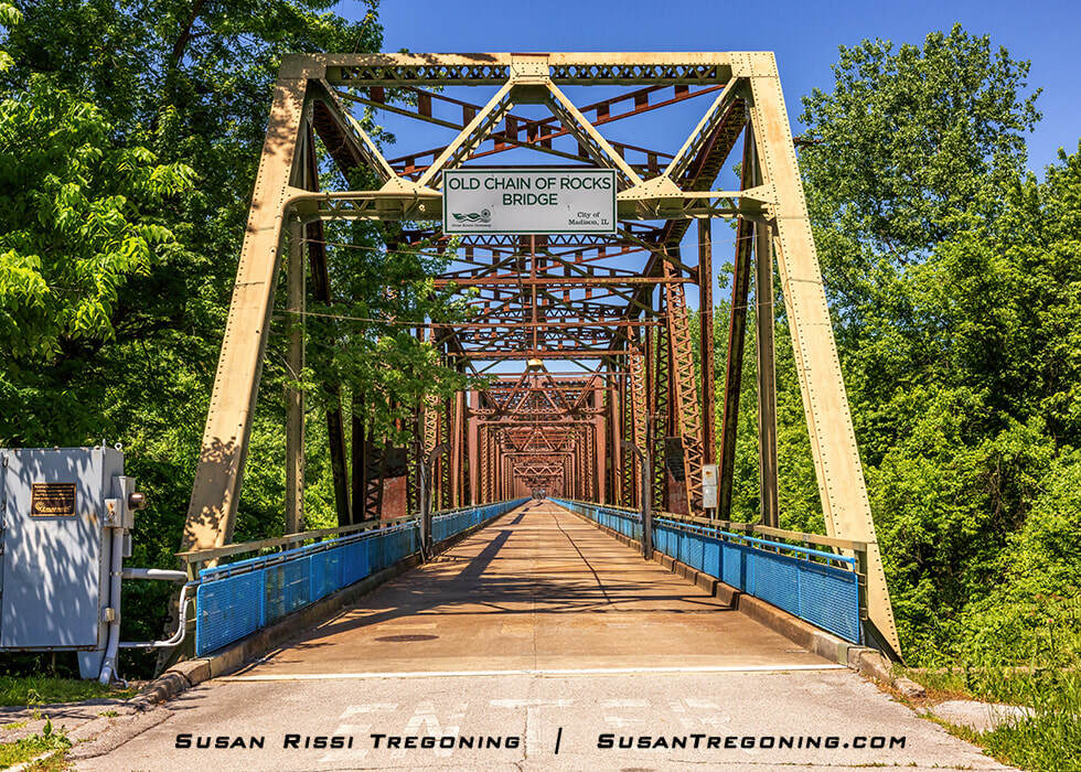
The Illinois approach to the Old Chain of Rocks Bridge, used as a Route 66 crossing over the Mississippi River for nearly three decades.
The Chain of Rocks Bridge was the third of five Route 66 river crossings into St Louis, earning its Route 66 designation in 1936. The Mother Road was initially routed across the McKinley Bridge. The second alignment in 1934 crossed MacArthur Bridge. Unfortunately, these two Route 66 corridors channeled traffic directly into the city's warehouse district, bottle necking downtown St. Louis.
The Chain of Rocks Bridge introduced travelers into the city from its northern side, passing the scenic Chain of Rock Amusement Park, one of St Louis's most picturesque locations, which is now gone. The addition of the bridge to the Route 66 bridge lineup helped ease the amount of traffic in the St Louis downtown area, and as a result, the Chain of Rocks Bridge ended up being used the longest, from 1936 to 1965.
Since St. Louis was known as the Gateway to the West, the Chain of Rocks Bridge was considered a significant milestone for long-distance travelers back in the day. They claim it was an absolute pleasure to cross on a beautiful day. The bridge had beautifully landscaped approaches. On the Illinois side, the four-mile-long road was gracefully elevated with dirt fill, allowing for beautiful long-distance views, and it was landscaped with four hundred elm trees. An ornate toll booth in a park-like setting near a pond anchored the Missouri side of the bridge. The river bank was lined with brightly lit motels and restaurants—a beacon to the tired and hungry. High up on the bluffs was the picturesque Chain of Rocks Amusement Park overlooking the Mississippi River and the Chain of Rocks Bridge. The amusement park operated from 1927 to 1978, when Six Flags put it out of business.
66 Auto Court Sign Exhibit on the Bridge
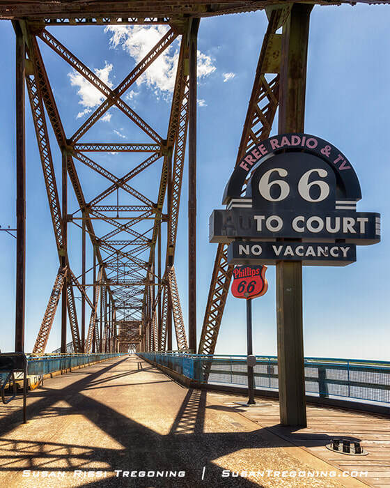
A recreated 66 Auto Court sign marks Missouri’s Route 66 heritage display on the Old Chain of Rocks Bridge.
The 66 Auto Court once stood at 8730 Watson Road in St. Louis, proudly promoting itself as “St. Louis’s Finest Modern Auto Court.” Like many mid‑century motor courts along the Route 66 corridor, it offered travelers a tidy row of wood‑framed cabins, easy parking, and the promise of modern convenience just outside the city.
After the auto court closed in 1978, the property took a sharp turn from its roadside‑lodging roots. The HideAway Club Massage Parlor moved into the former cabins, but the business was soon raided for prostitution and shut down. With the buildings sitting vacant and deteriorating, the St. Louis Fire Department eventually used the old structures for training burns in 1981, bringing an end to the last remnants of the motor court.
Today, the site has been completely redeveloped. The Watson Auto Care Plaza occupies the former auto court footprint, with no visible trace of the cabins or the roadside lodging that once greeted Route 66 travelers heading toward St. Louis.
Its History as a Toll Bridge
Originally built as a privately owned toll bridge, construction began in 1927, simultaneously on both sides of the river. The piers were completed by August 1928, and the bridge's grand opening was planned for New Year's Day 1929. However, flooding and ice slowed construction, and the Chain of Rocks Bridge finally opened in July of that year. When completed, the bridge cost just over $2.5 million, twice its original estimate.
The toll was only five cents to cross the bridge, but it was rarely used. By 1931, the Chain of Rocks toll bridge had lost money and was placed into receivership.
In 1935, the City of Madison, Illinois, issued $2.5 million in bonds and raised funds to purchase the bridge. It was fantastic foresight on their part since the Chain of Rocks Bridge was designated as a Route 66 bridge the following year, and it suddenly became a huge money maker.
The toll later increased to twenty-five cents. During World War II, it rose to 35 cents per car, with an additional five cents per passenger were charged to each vehicle. The increased toll paid for repainting sections of the bridge to green. They had been red, but during the war, the bridge needed to be less visible from the air since it was a significant infrastructure. The increased toll also offsets maintenance costs caused by wartime gas rations, reducing the traffic utilizing the bridge.
Route 66–style bike rack installed on the Missouri approach to the Old Chain of Rocks Bridge.
In 1967, the New Chain of Rocks Bridge opened just 2000 feet upstream, carrying Interstate 270 across the river. Around the same time, Madison made the old Chain of Rocks Bridge a free bridge, but because of its width and that infamous 30-degree bend, no one used it. Finally, when the maintenance cost became too much, Madison closed it in 1968.
Construction of the Bridge
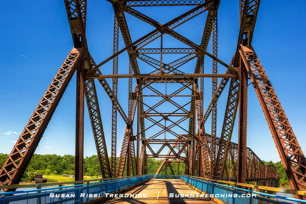
View approaching the 30‑degree bend on the Old Chain of Rocks Bridge, the historic Route 66 crossing linking Illinois and Missouri.
The Old Chain of Rocks Bridge was designed to be straight, like any typical bridge. However, river captains argued that bridge piers placed so close to the water intake towers and the already dangerous rapids would make it impossible for them to navigate large vessels and barges through there. Then, it was discovered that there was insufficient solid bedrock to support the weight of the piers. So, the only solution was to move the supports until solid bedrock was found, placing a 30-degree bend in the bridge. While that helped with boat navigation, it was a nightmare for drivers on the bridge!
The Chain of Rocks Bridge designer assured officials that the bend in the bridge would not be a problem for drivers, but accidents were common. Initially, there was less traffic on the road, so the bridge's width, at only 24 feet wide, may not have been a concern, but as time passed, semi-trucks became more common, and automobiles became larger.
There's a story about two RVs meeting at the bend. Both were stopped entirely on the bridge, and neither one could move as traffic backed up behind them in either direction. Finally, some motorists exited their cars, directing the RVs as they inched through the bend. They would never have passed each other independently since there was only one inch of clearance between them. As a result, traffic was backed up for an hour.
I have also read accounts saying cars had to stop entirely on the bridge if they met a big truck at the bend since it was in their lane. But that may have even happened when driving the straight-a-way since the bridge was so narrow. Think of it this way. A semi is about 8.5 feet wide. In a 12-foot lane, a perfectly centered truck would only have 21 inches of clearance on either side if they stayed in their lane. Because of their length, big trucks most likely had to take the curve diagonally, right through the center.
I can't even imagine driving across this bridge today. It had to be a real steering wheel clutcher!
The Chain of Rocks Shoal
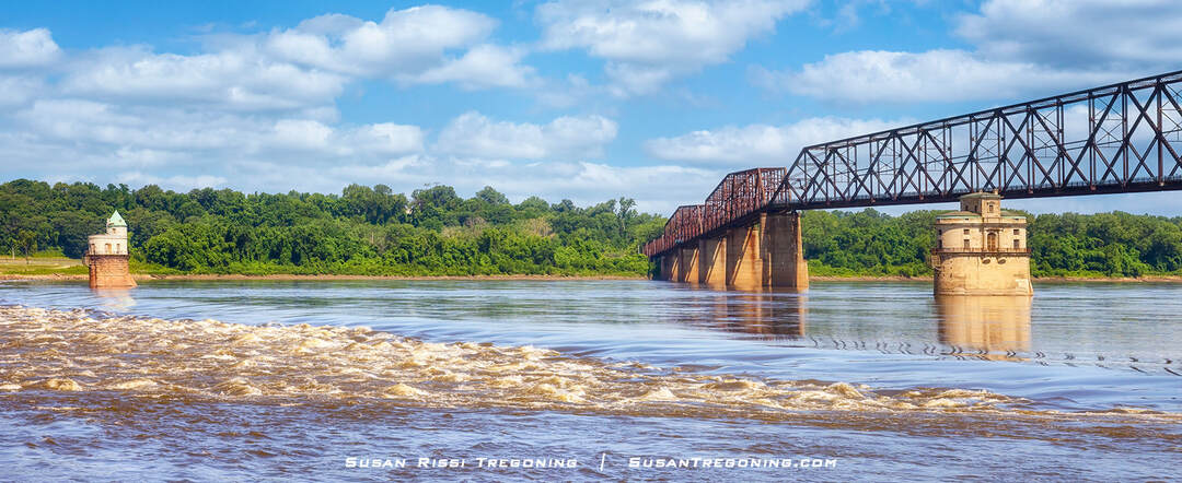
The Mississippi River is seen below the Old Chain of Rocks Bridge near the Chain of Rocks shoal and historic St Louis water intake towers. After the low water dam was installed, the Chain of Rocks shoal can no longer be seen unless the river level is extremely low.
By 1940, the Chain of Rocks was the only impediment preventing a safe and reliable nine-foot-deep navigational channel along the Mississippi River route from St. Paul, Minnesota, to New Orleans, Louisiana. In the late 1940s, the Army Corps of Engineers began constructing an 8.4-mile-long Canal to bypass the treacherous Chain of Rocks shoal. The Chain of Rocks Canal was completed in the early 1950s. When you reach the stop light at the one-lane bridge on Chain of Rocks Road, this bridge is over the navigational channel.
Finally, in the 1960s, a low-water dam was constructed across the river, ensuring adequate depths in the pool below Lock and Dam number 26. Since the low-water dam was built, the river level must be extremely shallow to see the Chain today. This new dam is Dam Number 27, also known as the Chain of Rocks Dam.
St Louis Water Intake Towers
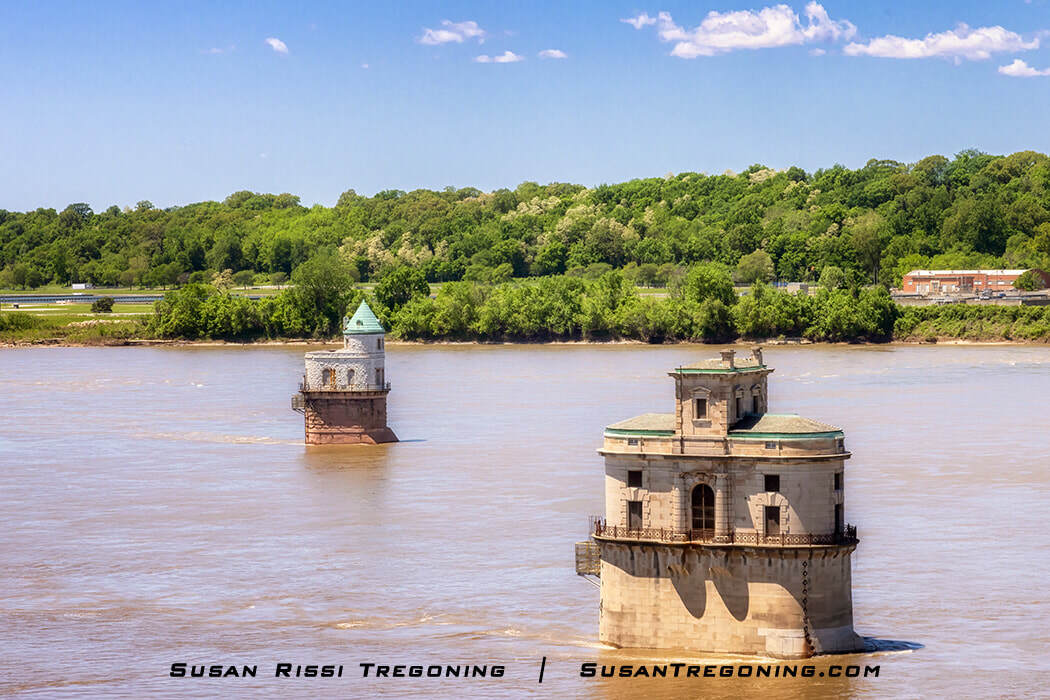
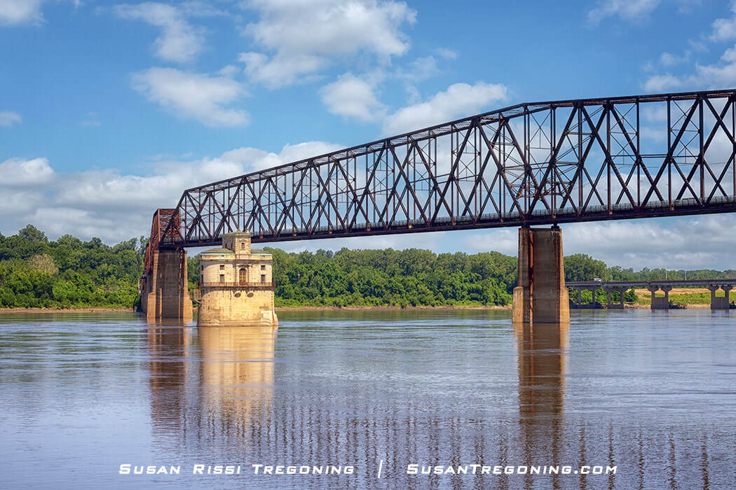
Looking down on the magnificent St. Louis Chain of Rocks Water Intake Towers that sit beside the Old Chain of Rocks Bridge in the middle of the Mississippi River.
The Chain of Rocks became the designated site for the St. Louis waterworks in 1865, chosen for its reliable river flow and natural limestone ledge that created a consistent drop in the Mississippi. Work on the new water plant began in 1887, part of a major civic effort to modernize the city’s water supply, and the system was completed in 1894.
As St. Louis continued to grow, the city expanded the facility with a large filter plant in 1915—a state‑of‑the‑art addition that was considered the largest filtration plant in the world at the time. Together, the intake towers, pumping station, and filtration complex formed one of the most ambitious municipal water systems of the early 20th century, anchored at the distinctive bend in the river known as the Chain of Rocks.
Intake Tower #1, completed in 1894, is the older of the two St. Louis river intake structures and the one positioned closest to the Missouri shoreline. Designed by architect William Eames, the tower reflects the Richardsonian Romanesque style, expressed through its heavy masonry, rounded arches, and fortress‑like massing. Its distinctive oval plan and green conical roof give it a castle‑like silhouette rising directly from the Mississippi River.
The tower’s appearance has long invited comparison to European river fortifications, most notably the Mäuseturm (Mouse Tower) on the Rhine near Bingen, Germany. While smaller in scale, Tower #1 shares the same storybook verticality and isolated mid‑river presence, making it one of the most visually striking components of the historic Chain of Rocks waterworks.
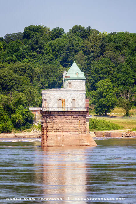
St. Louis waterworks intake tower #1 near the Missouri shoreline at the Chain of Rocks.
By 1913, the original Intake Tower #1 could no longer keep pace with St. Louis’s rapidly increasing water demands. The city’s population and industrial output had grown far beyond what the 1894 tower was designed to handle, and engineers determined that a second mid‑river intake was necessary to maintain adequate supply and pressure. This need set the stage for the construction of Intake Tower #2, a larger and more technologically advanced structure that would expand the capacity of the Chain of Rocks waterworks and support the city’s early‑20th‑century growth.
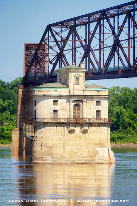
The 1915 St. Louis intake tower #2, a Roman Renaissance landmark rising mid‑river at the Chain of Rocks.
Intake Tower #2, completed in 1915, stands in the center of the Mississippi River and represents the second phase of St. Louis’s ambitious Chain of Rocks waterworks. Designed by the architectural firm Roth and Study, the structure departs from the Romanesque massing of Tower #1 and instead embraces a Roman Renaissance aesthetic. Its form was intentionally crafted to resemble a Roman villa, with classical proportions and a more refined architectural expression rising directly from the river.
Unlike Tower #1, the second tower was built to house full living quarters for the crews who worked in continuous shifts to manage the city’s water intake. These workers lived on site—sleeping, eating, and maintaining the equipment—so the flow of water from the Mississippi could be monitored around the clock. The tower remained fully staffed until the late 1920s, when technological improvements finally made permanent on‑site residency unnecessary.
Today, Tower #2 remains one of the most distinctive pieces of early‑20th‑century civic infrastructure on the Mississippi, its villa‑like silhouette marking the midpoint between the Missouri and Illinois shores.
The two Water Intake Towers were designated St Louis City Landmarks in 1971.
The Old Chain of Rocks Bridge in the foreground, with the modern Chain of Rocks Bridge spanning the river behind it.
The old Chain of Rocks Bridge was no longer used after the new one opened upstream in 1967.
Finally closing in 1968, the Army demolition team considered blowing it up for practice in the early 1970s. That almost happened in 1975, but thankfully, the price of steel plummeted, and it was no longer profitable as scrap metal for the bridge to go out with a bang. The bridge lingered in uncertainty for 20 years, abandoned, while it continued to deteriorate—too expensive to tear down, too narrow, and outdated for today's vehicles. It was used as the "69th Street Bridge" in the movie Escape from New York, filmed in 1981. Sadly, it acquired a reputation as a location of crime and violence, and in 1991, it was the spot where sisters Julie and Robin Kerry were murdered. Finally, in 1998, Trailnet leased the bridge, spending $4.5 million to renovate it for pedestrian and bicycling use. That lease was transferred to the Great Rivers Greenway District in 2014. As the northern point of the Mississippi Greenway, it connects more than 300 miles of trails on both sides of the river.
The Old Chain of Rocks Bridge was added to the National Register of Historic Places in 2006 for its significance in transportation during the Route 66 era. The bridge is the widest river crossing along the Mother Road and provides access to the largest city between Route 66's two termini. As one of the longest bridges of its type, the Chain of Rocks Bridge is a historically significant example of early bridge building. In addition, its 30-degree bend makes it highly unique.
Visiting the Illinois Side of Old Chain of Rocks Bridge
4205-4207 Chain of Rocks Road, Granite City, Illinois
GPS: 38.7573409,-90.1655625
The Old Chain of Rocks Bridge is gated for safety reasons. Volunteer bridge keepers open it daily at 9 am, and the Madison County Police Department closes it 30 minutes after sunset. During icy conditions, the bridge may not open.
UPDATE: When I visited the Chain of Rocks Bridge, parking on the Missouri side had been closed for many years. Therefore, my directions are only for the Illinois side of the bridge.
I’m excited to announce that Missouri’s Chain of Rocks Park reopened on Sunday, April 14, 2024.
I recently visited the park. It has a nice parking lot and access to the bridge, but since Illinois owns the bridge, I found no Route 66 information on the grounds. Unless you plan to hike the entire bridge, I still recommend following my directions.
Just an FYI…
Getting there should be easier than it is, but I've read many complaints on review sites from people trying to get to the old bridge and being frustrated because it's so hard. I had problems, too.
If you are using your GPS, it may take you to the Missouri side of the old bridge or to the New Chain of Rocks Bridge. If all else fails and the address or GPS Coordinates do not work, use my driving directions below.
The New Chain of Rocks Bridge is I-270.
If you are in Missouri, just get to the Illinois side of the Mississippi River.
If you are in Illinois, don't cross the New Chain of Rocks Bridge into Missouri.
Driving Directions:
- Exit from I-270 on the Illinois side of the river; take the IL–3 Exit.
- Head south.
- Turn Right onto Chain of Rocks Road. This is the first intersection you come to on IL-3.
- Cross the one-lane Chouteau Island Canal Bridge. Be sure to pull up far enough to trigger the stoplight.
- Continue straight until the road dead-ends at the Chain of Rocks Bridge parking lot.
- The road down to the base of the bridge is on the left before the parking lot. If the river level is high, the road may be closed.
Not every image makes it into my blog. If you enjoyed the photos in this article, visit the Route 66 Collection to see more of my travels along the Mother Road, or check out my Illinois Collection for more pictures of this state. My Image Gallery has over 4000 images of locations around the United States.

The Old Chain of Rocks Bridge captured in situ along the Mississippi River, highlighting its rugged steel truss, enduring stone piers, and the timeless character that defines this historic Route 66 landmark.
Fine Art Prints are available for order as print only, framed art, canvas art, metal art, acrylic art, and wood art prints in various sizes. Home Decor and Gift Ideas include shower curtains, throw pillows, towels, totes, phone cases, t-shirts, puzzles, blankets and more—Worldwide Shipping with a 30-day money-back guarantee.
Other Route 66 Blog Posts
More of the USA
- A Travelers Musings (1)
- Alabama (1)
- Hawaii (3)
- Illinois (6)
- Indiana (3)
- Iowa (3)
- Louisiana (1)
- Maryland (1)
- Michigan (2)
- Minnesota (4)
- Mississippi (6)
- Missouri (2)
- Montana (1)
- Nebraska (5)
- New Mexico (1)
- North Carolina (1)
- Pennsylvania (2)
- Route 66 (5)
- South Dakota (1)
- Tennessee (1)
- Texas (1)
- Virginia (2)
- Washington DC (1)
- West Virginia (3)
- Wildlife (6)
- Wisconsin (2)
- Wyoming (4)
