- Published on
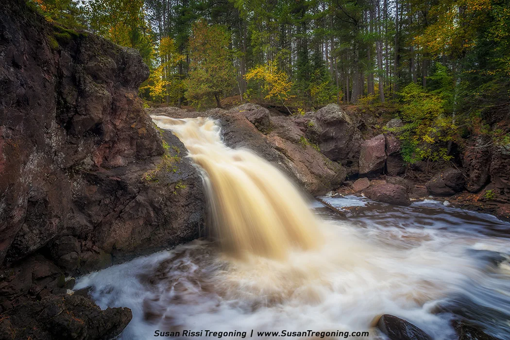
Silky autumn waters spill over rugged stone, carving a quiet moment deep within the forest.
One of my favorite places to see waterfalls in northwest Wisconsin is Amnicon Falls State Park. Located 15 miles east of Superior, Wisconsin, near Lake Superior, it is one of the easiest places to visit waterfalls on the Lake Superior Waterfall Tour.
This is a small park with only 2.4 miles of hiking trails. The best part of the trail, a 1/4 mile easy loop, is right off the parking lot. This is where you will find four named waterfalls, three smaller unnamed falls, and a historic bridge. None of these waterfalls are very large, but they are all very picturesque. The park is small enough to see the highlights in under an hour, but if you are a true waterfall lover, bring your lunch; you could easily spend most of the day.
- Published on
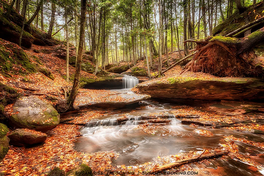
A quiet autumn moment along the gorge at Houghton Falls State Natural Area, where a small cascade slips over layered sandstone and gathers in a shallow, leaf‑strewn pool. Soft light filters through the hardwoods above, highlighting the season’s warm colors against the mossy rock.
In 2018, Wisconsin designated the road through the Bayfield Peninsula as its fourth official scenic byway. Named the Wisconsin Lake Superior Scenic Byway, this 70‑mile stretch of State Highway 13 curves around the South Shore of Lake Superior, offering sweeping views of deep forests, quiet beaches, and the ever‑changing waters of the “big lake.” Along the route, travelers pass through quaint harbor towns rich with historic architecture, old fishing villages, small orchards and fruit farms, and the homeland of the Red Cliff Band of Lake Superior Chippewa. At the heart of it all is Bayfield—the gateway to the Apostle Islands National Lakeshore and the Gaylord Nelson Wilderness Area.
Known primarily as a summer destination, I chose to explore the Bayfield Peninsula in autumn, when most visitors have gone home and the region settles into a quieter rhythm. Many attractions are closed for the season, but it’s the perfect time to reconnect with nature. The fall colors are absolutely electric, and the landscape feels like it’s revealing a side of itself that few travelers ever get to see.
- Published on
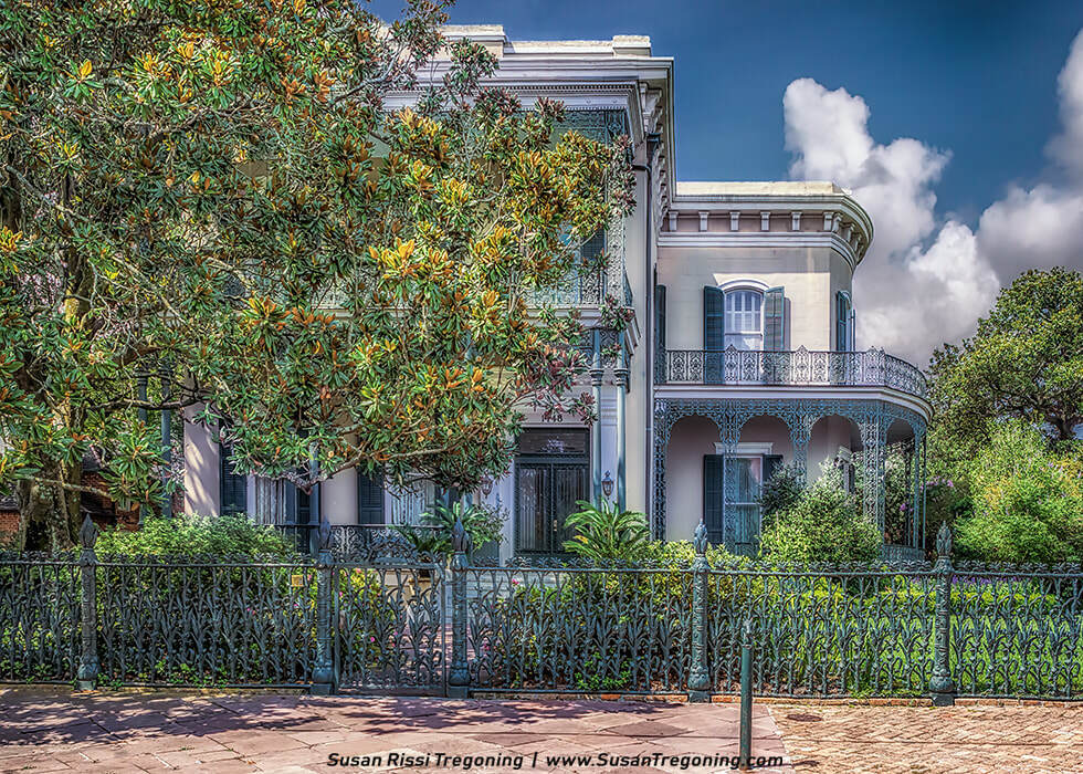
The elegant façade of Colonel Short’s Villa showcases tall shuttered windows, intricate wrought‑iron balconies, and an ornate ironwork fence that frames this classic example of Garden District architecture.
Following the Louisiana Purchase in 1803, Americans started to arrive in New Orleans and they wanted a neighborhood to call their own. It took thirty years to happen, but in 1826 when Jacques Livaudais failed to show up for divorce court, he lost ownership of the family plantation to his wife. In 1832, she moved home to France and sold the property to a group of businessmen who saw this land as America’s answer to the French and Creole-dominated Vieux Carre. They parceled it into a grid of 80 city blocks, becoming part of the Village of Lafayette.
Wealthy Americans flocked to build mansions here. With plenty of space, each mansion was surrounded by huge lawns and gardens, some spanning full city blocks, which earned the area its nickname, the “Garden District”. That nickname stuck, and the Garden District became its official name when the neighborhood was annexed into New Orleans in 1852.
- Published on

Cave‑In‑Rock rises above the Ohio River, its massive limestone bluff and natural cave opening reflected in the calm shoreline.
A cave called Cave‑In‑Rock sits along the banks of the Ohio River in a quiet southern Illinois town that shares its name. Its recorded history begins in 1739, when French explorer M. DeLery mapped the limestone cavern and labeled it caverne dans Le Roc, a name that, once translated, remains in use today. Although many of the stories tied to this place are unverified, the folklore surrounding Cave‑In‑Rock began almost immediately after its discovery, weaving tales of riverboat pirates, bandits, fugitives, and murderers who were said to have used the cave as a hideout. Today, the site is one of the featured stops along the Illinois section of the Ohio River Scenic Byway, drawing visitors for both its natural beauty and its legendary past.
- Published on
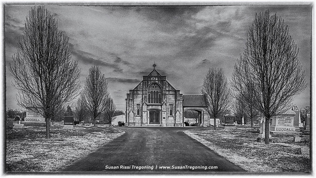
Goddard Chapel stands at the heart of Rose Hill Cemetery in Marion, Illinois, its Gothic stonework framed by bare trees and a moody Midwestern sky.
I have always loved this beautiful old chapel. As early as four or five years old, I can remember staring out the car window in excitement and maybe with just a touch of trepidation as I waited to get my first glimpse of it anytime my parents drove down Route 37. It became even more interesting to me when I discovered that it was built by an ancestor of mine and that the two most prominent tombstones on either side are ancestors too.
I have been planning this image for a long time. It could be called, "Memories of my Youth", for when cemeteries were scary places to visit. In my mind's eye as a five year old, this is what the Goddard Chapel looks like...
- Published on
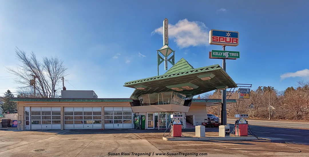
Frank Lloyd Wright’s only gas station stands in Cloquet, Minnesota, its angular canopy and “F.L. Wright” spire marking one of the architect’s most unexpected designs.
Only a 30-minute drive west of Duluth, Minnesota, on the edge of the St. Louis River, is a little logging town in the North Woods called Cloquet. This town began as a group of small settlements around three sawmills: Shaw Town, Nelson Town, and Johnson Town. Today, it has a population of a little over 12,000 people.
Many people would be very surprised to learn that this quiet little town is uniquely tied to America’s greatest architect, Frank Lloyd Wright. Cloquet is the location of the only functioning gas station ever designed and built by Mr. Wright. It is also the only piece of Wright’s Broadacre City project ever to be constructed.
Author
Susan Tregoning is a fourth‑generation photographer and Midwest-based visual storyteller dedicated to preserving America’s architectural and roadside heritage. Drawing on her design background and a lifelong connection to photography, she documents historic buildings, small towns, and scenic byways across the region. Her work creates thoughtful visual records that honor the character, craftsmanship, and cultural memory embedded in places that are often overlooked yet define the American experience.
Across the USA
- A Travelers Musings (1)
- Alabama (1)
- Hawaii (3)
- Illinois (6)
- Indiana (3)
- Iowa (3)
- Louisiana (1)
- Maryland (1)
- Michigan (2)
- Minnesota (4)
- Mississippi (6)
- Missouri (2)
- Montana (1)
- Nebraska (5)
- New Mexico (1)
- North Carolina (1)
- Pennsylvania (2)
- Route 66 (5)
- South Dakota (1)
- Tennessee (1)
- Texas (1)
- Virginia (2)
- Washington DC (1)
- West Virginia (3)
- Wildlife (6)
- Wisconsin (2)
- Wyoming (4)