The Middle of the Trace : The Natchez Trace Parkway - Top Half of Mississippi
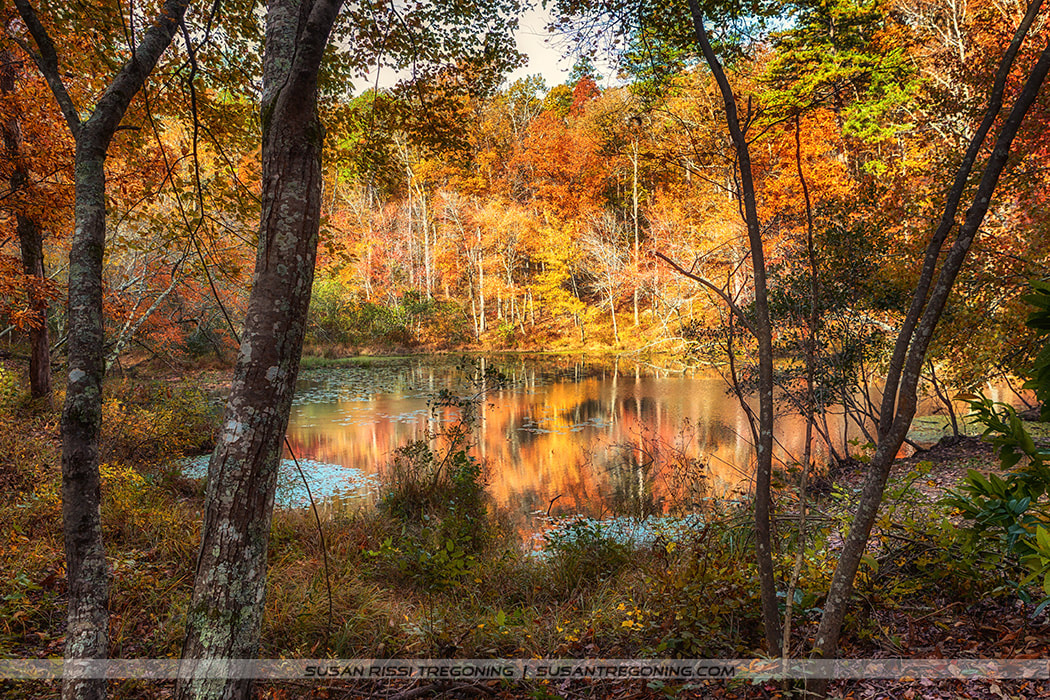
Autumn color settles over a quiet pond at Tishomingo State Park near Tupelo, Mississippi, where the hardwoods reflect in still water and the forest floor begins its seasonal shift toward gold and rust.
Part Two carries us into the northern half of Mississippi, where the Natchez Trace Parkway winds through wooded hollows, archaeological sites, and some of the most peaceful preserved segments of the Old Trace.
This section continues the journey down the historic Natchez Trace, the early travel corridor linking Nashville and Natchez.
If you missed the origin story of the Trace, you can read the full history in Part 1.
The Mississippi portion of the Natchez Trace Parkway spans 308.8 miles. For this guide, I’ve divided the state roughly in half, and this post covers the northern section of the Mississippi Trace, from milepost 308 down to milepost 160.
Milepost markers along the Natchez Trace Parkway are located on the east side of the road, and in this series I’m traveling the Trace backward — counting the mile markers down as I go.
For planning your own trip, you can download Natchez Trace Map online, and printed copies of the official map are widely available along the Parkway. Don’t travel the Trace without one — you’ll miss so many of the sites that make this road special.
Part 2 of the Mississippi Natchez Trace Parkway Highlights
#304.5 - Tishomingo State Park
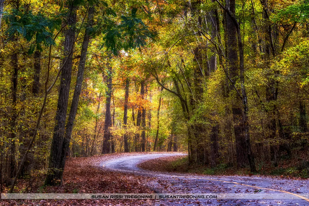
A quiet forest road winds through the vibrant autumn colors of Tishomingo State Park, where sunlight filters softly through the trees and fallen leaves blanket the path.
In the northern section of Mississippi, the Natchez Trace Parkway travels through the middle of Tishomingo State Park.
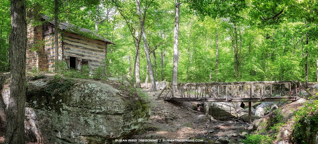
The rustic log well house at Tishomingo State Park, built by the Civilian Conservation Corps in the 1930s, rests on a natural rock ledge above a clear, stone‑lined stream. A simple wooden footbridge leads visitors across the water, framed by dense hardwood forest and soft afternoon light.
Considered Mississippi’s most scenic state park, it is located in the foothills of the Appalachian Mountains where massive boulders and rock formations blanket the forested hills. The major feature of the park is Bear Creek Canyon and its beautiful sandstone outcroppings.
This area was once the home of the Chickasaw Tribe. The park is named after Chickasaw Chief Tishomingo, one of the last full-blooded Chickasaw Chiefs. Pronounced “Tishu-minko,” his name means assistant-king since he was second in power to the Minko or hereditary king. Tishomingo served under Andrew Jackson during the War of 1812. He died at approximately 100 years old on the Trail of Tears.
The park was established in the 1930s as part of the New Deal. It has 13 miles of hiking trails, camping, fishing, and rock climbing.
One of the park’s historic exhibits is a restored 1840s log cabin set in a wooded area with a boulder-strewn brook and outdoor well.
The Swinging Bridge, another popular landmark, is a 200-foot-long swinging bridge across Bear Creek.
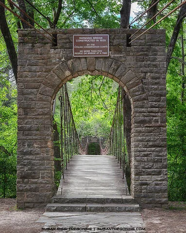
The historic Swinging Bridge at Tishomingo State Park, completed by the Civilian Conservation Corps in 1939, begins beneath a hand‑laid stone archway marked with a bronze CCC plaque. The wooden‑plank suspension bridge stretches roughly 200 feet across Bear Creek, carried by steel cables into the surrounding hardwood forest—one of the park’s most iconic and enduring CCC structures.
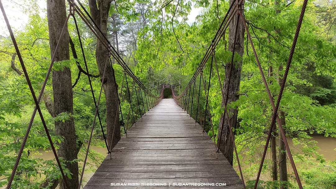
From this forest‑level perspective, the Swinging Bridge at Tishomingo State Park reveals its full suspension character—wooden planks carried by heavy steel cables and anchored deep into the surrounding hardwoods. Built by the Civilian Conservation Corps in 1939, the bridge spans roughly 200 feet across Bear Creek, offering one of the park’s most immersive and iconic woodland crossings.
#286.7 - Pharr Mounds
Listed on the National Register of Historic Places, the Pharr Mounds site has eight burial mounds built 1,800 to 2,000 years ago during the Middle Woodland period. It is one of the largest Middle Woodland ceremonial sites in the southeastern United States.
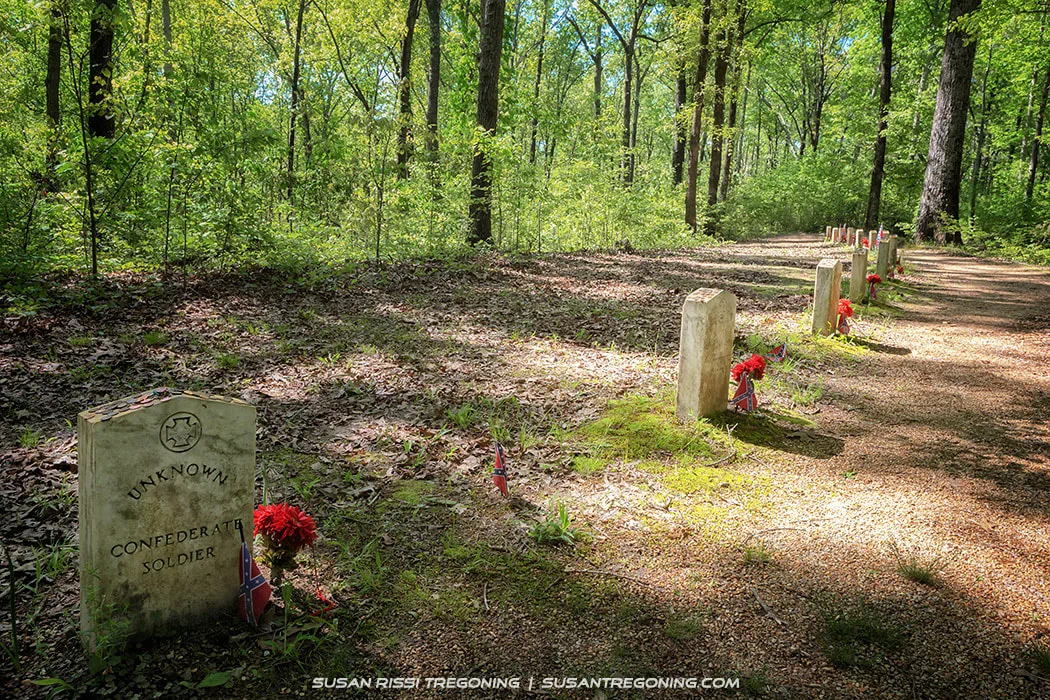
#269.4 - Old Trace & 13 Confederate Gravesites
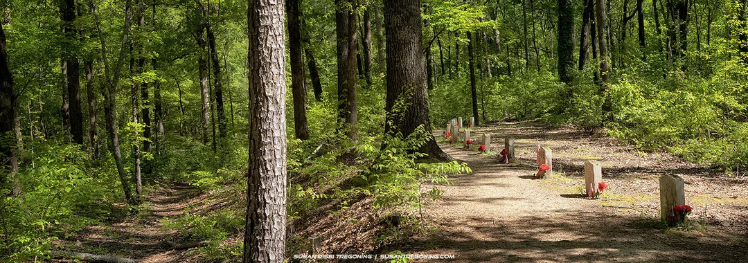
Along a shaded stretch of the Natchez Trace lies the historic “13 Graves” site, a row of small stone markers set beside a forest path. Their origins remain uncertain—local lore offers multiple theories—but the setting is undeniably solemn, with red flowers placed at each marker beneath the filtered light of the hardwood canopy.
At eye level, with stones facing towards the Old Natchez Trace, are the thirteen graves of Unknown Confederate Soldiers. Placed so that anyone passing by could see and pay their respects to these thirteen men, this is the most moving location along the 444-mile Natchez Trace Parkway.
A quiet row of marked graves rests beneath the hardwood canopy along the Natchez Trace, each stone honoring an unknown Confederate soldier. Small flags and red flowers stand at their bases, adding a touch of color to the shaded forest path. The setting is peaceful and reflective, a solemn reminder of the many untold stories that linger along the old road.
It is a mystery how these thirteen Confederate soldiers came to be buried alongside the Trace. No battles took place near here. Could they have been wounded during the Shiloh or Corinth Battles and retreated along the Trace, or possibly guarding the Tupelo headquarters of J.B. Hood’s Army of Tennessee at the end of the Civil War? Or worse, did they die of starvation or one of the many diseases that raged through the army camps while trying to make their way home after the war?
We will never know.
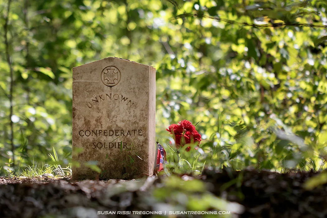
A lone gravestone marked “Unknown Confederate Soldier” stands quietly beneath the hardwood canopy along the Natchez Trace. Red flowers rest at its base, adding a small touch of color to the shaded forest clearing. It’s a solemn reminder of the many unnamed stories tied to this historic road.
#259.7 - Tupelo National Battlefield
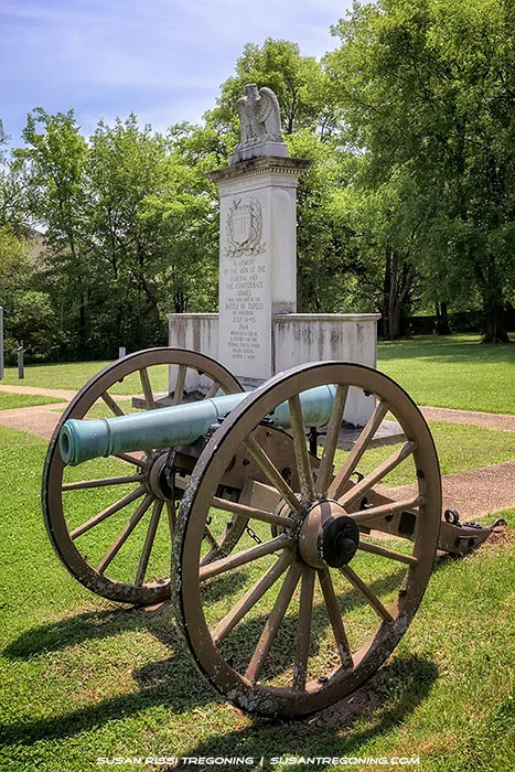
A bronze‑green field cannon stands before the tall stone monument topped with an eagle, marking the site where Union forces halted Confederate attempts to disrupt Sherman’s supply lines during his Atlanta Campaign. The peaceful, tree‑lined setting contrasts sharply with the fierce fighting that once took place here.
You must leave the Trace to see the Tupelo National Battlefield. There is not a lot to see here, just the memorial.
This memorial commemorates the Civil War Battle of Tupelo, also known as the Battle of Harrisburg, fought on July 14 and 15, 1864. It was a Union victory that ensured the safety of Sherman’s supply lines during the Atlanta Campaign.
Exit the Natchez Trace Parkway at milepost #259.7. One mile east on Main Street, the physical address is 2005 Main Street, Tupelo.
As a side note...
Tupelo is the Birthplace of Elvis.
If you visit the Battlefield, you might also want to spend a day or two exploring the Elvis Presley sites.
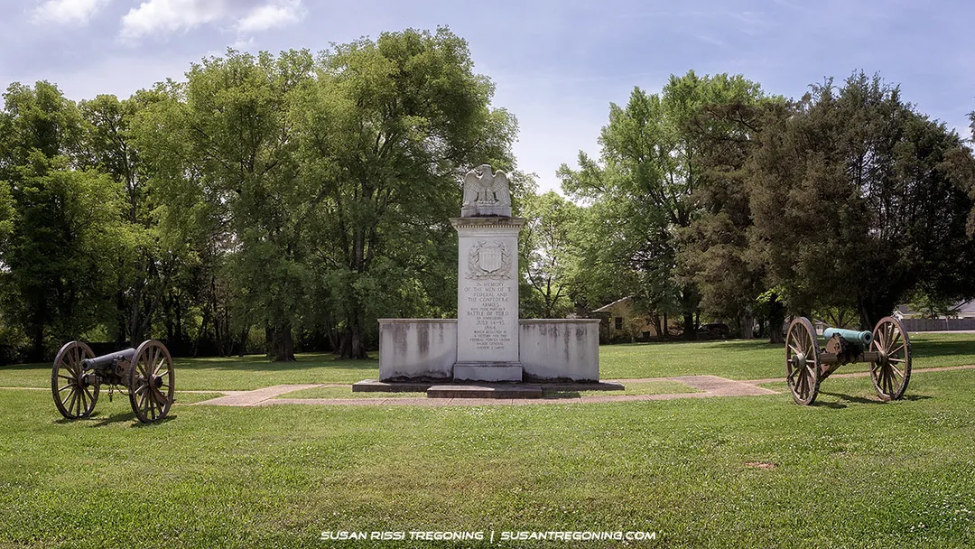
The Tupelo National Battlefield memorial stands quietly on the site of the 1864 Battle of Tupelo—also known as the Battle of Harrisburg—where Union forces halted Confederate attempts to disrupt Sherman’s supply lines. A tall stone monument topped with an eagle rises at the center, flanked by two field cannons set on wooden wheels. The peaceful, tree‑lined landscape offers a calm contrast to the fierce fighting that once unfolded here.
#232.4 Bynum Mounds
Listed on the National Register of Historic Places, the Bynum Mounds site has six burial mounds built 2,050 to 1,800 years ago during the Middle Woodland period. Five of the mounds were excavated in the late 1940s, and the two largest were restored for public viewing.
#193.1 - Jeff Busby Park
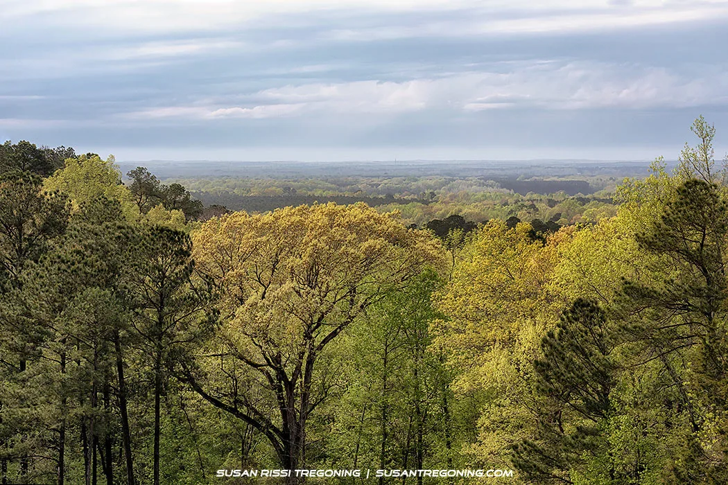
The view from Little Mountain at Jeff Busby Park stretches across a vast sweep of Mississippi forest, layer after layer of treetops fading into the distant hills. Soft light filters through the clouds, revealing the depth and quiet beauty of one of the highest points along the Natchez Trace Parkway.
Jeff Busby Park is named to honor Thomas Jefferson Busby, the US Congressman who was responsible for getting the Old Natchez Trace survey done in 1934. Four years later, the Trace was designated part of the National Park System, preserving this important piece of Mississippi and American history.
The park is mainly a camping and picnic area with a scenic overlook at the top of Little Mountain. You can drive or hike to the top of Little Mountain. At 603 feet high, it is one of the highest points in the state. On a clear day, you can see about 20 miles.
#180.7 - French Camp
In 1812, Lewis LeFleur opened a stand about 900 feet northeast of the Natchez Trace. LeFleur married a Choctaw woman and had a son. The son changed his last name to Leflore. Greenwood Leflore became famous for being a Choctaw chief and a Mississippi State Senator. The city of Greenwood and the county of Leflore were named after him.
Because of Lewis LeFleur's nationality, the area became known as “French Camp.” When the village grew up around the stand, it retained that name. Although the inn no longer exists, the small town of French Camp is still here along The Trace.

Today, French Camp is home to a Christian school, the French Camp Academy. They also run the French Camp Historic Village and the French Camp Bed and Breakfast.
The French Camp Village is an official tourist attraction along the Natchez Trace Parkway. It has several historic buildings, including the Colonel James Drane House, LeFlore Carriage House, and a Blacksmith Shop. The Village is open to the public from 9 to 5 Monday through Saturday.
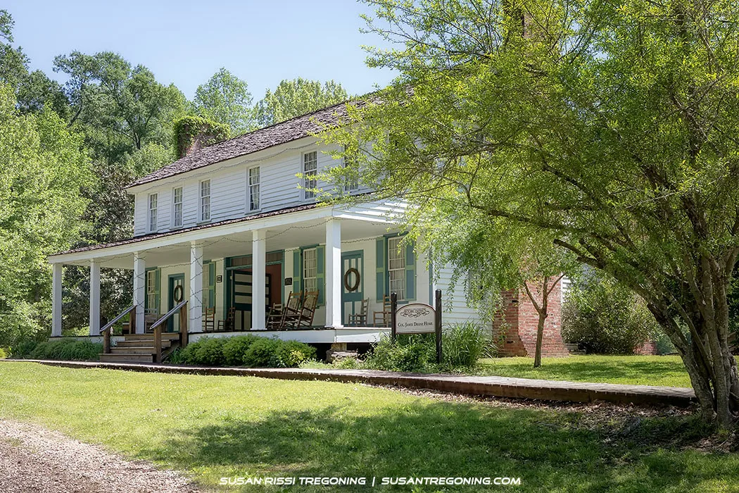
The Colonel James Drane House, originally built in the 1840s, was moved to its present location along the Natchez Trace Parkway in 1981. The two‑story frame home, with its broad front porch and shaded setting, now stands as a preserved example of early Mississippi architecture and a quiet reminder of the region’s antebellum history.
The Colonel James Drane House was moved to its present location along the Natchez Trace Parkway in 1981. Colonel Drane was the most prominent early settler of Choctaw County. He served as a state representative, senator, and president of the Mississippi State Senate.
The house is one of only a few antebellum structures in the county. Constructed 1846-48 with a water saw, it has wooden pegs and square nails. The house was placed on the National Register of Historic Places in 1983 because the design is highly significant in the architectural history of Mississippi. Architecturally, it is described as a well-preserved wood-frame single-galleried I-house with a seven-bay façade and an open dogtrot on the lower story; it is an example of the blending of folk architecture with sophisticated ornamentation borrowed from the East Coast.
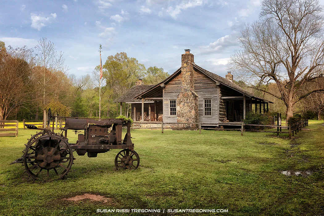
An old rusty tractor sits in front of the Alumni Cabin Museum at French Camp Village, its metal wheels and weathered frame echoing the community’s early agricultural roots. The log cabin, with its stone chimney and porch rocking chairs, stands quietly behind it, creating a timeless scene along the Natchez Trace Parkway.
An old tractor sits in the yard at the French Camp Village. In the background is the Alumni Cabin Museum. The cabin, built in the 1880s, is full of Natchez Trace memorabilia, such as dresses, antiques, farm equipment, and photographs.
Take the time to check out the wildlife along the way. They may be just as curious about you!

A pair of Eastern Bluebirds pause at the birdhouse entrance, eyeing me with curiosity as they check out the space and decide whether it might suit their nesting plans.
This is Part 2 of a 3‑part series. You may also be interested in reading:
Part 1: Top of the Trace — The Natchez Trace Parkway: Tennessee & Alabama
Part 3: Bottom of the Trace — The Natchez Trace Parkway: Bottom Half of Mississippi
Not every image makes it into my blog. If you enjoyed the photos in this article, please check out my Tennessee, Alabama & Mississippi Collections for more pictures of this beautiful state, or visit my Gallery with over 4000 images of locations around the United States.

Bring the timeless charm of French Camp Village into your home with this rustic wall art featuring an old tractor resting beside a historic log cabin. Warm earth tones, rich textures, and classic rural details make this piece an inviting focal point for any cozy, country‑inspired space. A perfect choice for collectors who appreciate heritage, craftsmanship, and the quiet beauty of the Natchez Trace Parkway.

Fine Art Prints are available for order as print only, framed art, canvas art, metal art, acrylic art, and wood art prints in various sizes. Home Decor and Gift Ideas include shower curtains, throw pillows, towels, totes, phone cases, t-shirts, puzzles, blankets and more—Worldwide Shipping with a 30-day money-back guarantee.
More of the USA
- A Travelers Musings (1)
- Alabama (1)
- Hawaii (3)
- Illinois (6)
- Indiana (3)
- Iowa (3)
- Louisiana (1)
- Maryland (1)
- Michigan (2)
- Minnesota (4)
- Mississippi (6)
- Missouri (2)
- Montana (1)
- Nebraska (5)
- New Mexico (1)
- North Carolina (1)
- Pennsylvania (2)
- Route 66 (5)
- South Dakota (1)
- Tennessee (1)
- Texas (1)
- Virginia (2)
- Washington DC (1)
- West Virginia (3)
- Wildlife (6)
- Wisconsin (2)
- Wyoming (4)
